I have been waiting to write this post for four months.
For four very, very long months.
The four hottest months of summer in Houston on record, in fact. This summer was absolutely brutal in terms of daytime highs, overnight lows, and a drastic drought. So yeah, I’ve been waiting to write that the greater Houston region is going to see some meaningful rainfall, to be followed by the season’s first bonafide cold front. Relief is coming, and boy oh boy, is it going to be sweet. Look for high rain chances on Tuesday through Thursday, followed by a frontal passage on Friday. And then? Low humidity and cool nights!
As long as we’re writing about happy tidings and Houston, I’d also like to congratulate the Houston Astros and Texans. Like many of you, we’re big fans of the hometown teams, and Sunday was a big day. The Astros came from behind to sneak past the Texas Rangers to win their division, and set themselves up nicely for the playoffs. And behind the stellar play of their new rookies and head coach DeMeco Ryans, the Texans won their second game in a row. For the first time in a long time they look like a bonafide pro football team with great leadership. So, good tidings all around.
Monday
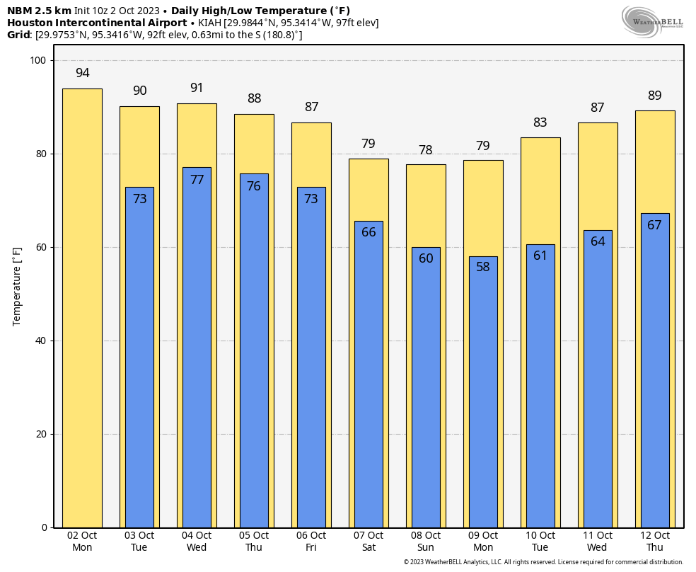
Today will see a continuation of this weekend’s weather, which is to say hot, sunny, and summer-like. Look for highs generally in the mid-90s, with an easterly wind that will at times be a bit gusty, and plenty of humidity. Lows tonight will drop only into the mid-70s for most of the area. Rain chances are near zero.
Tuesday, Wednesday, and Thursday
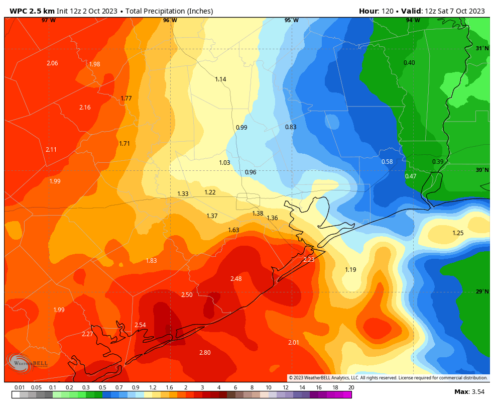
By Tuesday the pattern will begin to change, as the ridge of high pressure that has dominated our weather begins to back away. This will start to open up our region to tropical moisture that will move north from the central Texas coast. Rain chances will increase starting on Tuesday, and remain fairly high through Thursday. Most areas will at least see some light showers each day, with total accumulations likely between 1 to 3 inches over the three day period. A few areas will see more than this, possibly leading to some brief street flooding. Rain chances will be highest to the southwest, near Matagorda Bay, and lowest to the northeast of Houston.
Skies will turn partly to mostly cloudy and this, in concert with the on-and off-again showers should hold high temperatures to around 90 degrees, or slightly above, for much of the region. Expect plenty of humidity, with generally easterly to southeasterly winds.
Friday
We’re now fairly confident in the passage of a cold front on Friday, and this should bring an end to the showers later in the day. Highs on Friday will be highly dependent on your location, but generally we should be in the 80s, with drier air steadily moving in during the afternoon and overnight hours. Lows should drop into the 60s for all but the coast.
Saturday and Sunday
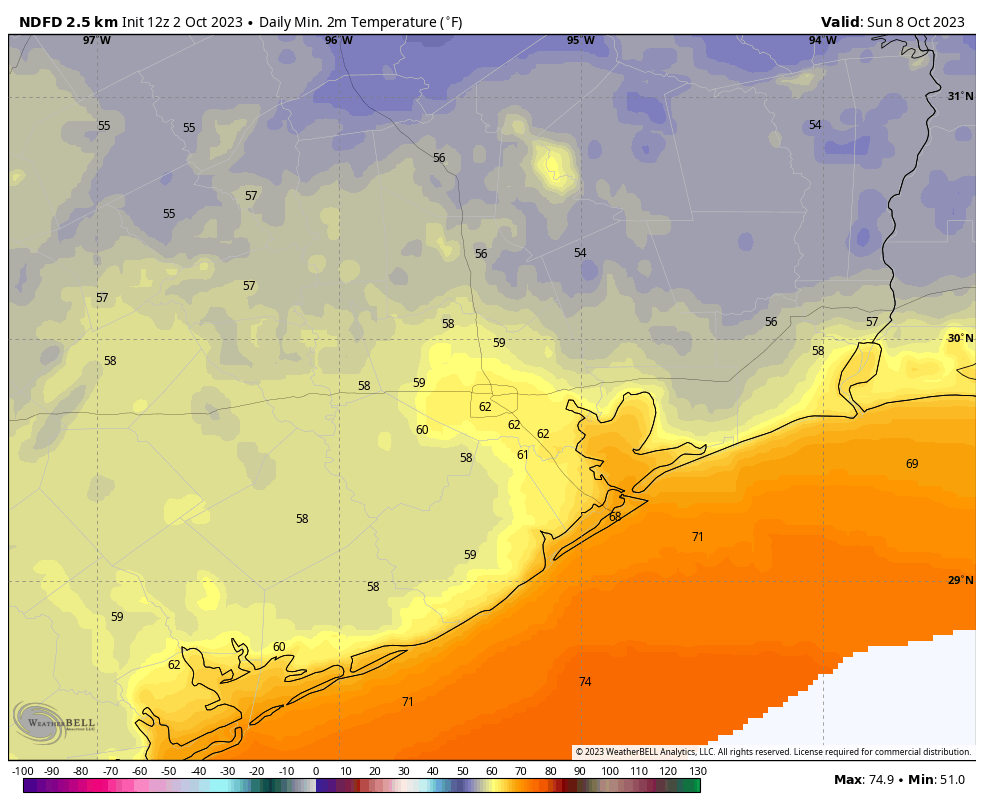
These look like a fine pair of sunny days with highs of around 80 degrees with drier air. Lows will drop to around 60 degrees in Houston, with some 50s for inland areas. We’ll work out just how cool things will get as we get closer to the weekend, but Sunday and Monday mornings are going to feel absolutely fall like for everyone.
Next week
The cooler weather will hang around at least into Tuesday or so, but after that we’re probably headed back into the upper 80s. As for this mid-90s nonsense we’ve been experiencing of late in Houston, I think we’re done with that for the year.


Are you declaring Fall Day yet?
Fall Day will probably be Saturday! I’ll make the definitive call tomorrow. Just want to be sure of the timing.
Yay!
Sunday forecast looks GLORIOUS.
When the weather guy starts referring to the weather as “nonsense”, you know it’s been bad.
Yup! My sentiments exactly. Should I get out some pants or will that jinx it?!
IT’S HAPPENING!!
Next week looks interesting as well. Current invest 98E in the Eastern Pacific is likely to turn into a tropical cyclone and get pulled into northern Mexico with its remnants ending up somewhere over Texas. At around the same time the tail end of the front may spin up something in the Bay Of Campeche.
I am preparing myself mentally for the local media hype train ramping up a “storm in the gulf” which has been mostly absent this year. Jim Cantore over on the Weather Channel has not waded around any water on the Gulf Coast this entire year but I feel that streak is going to end next week…
I agree that if anything gets into the Gulf there will be an inordinate amount of hype. But there’s a long way to go between here and there.
YEEEHAAW…Bring it on!!!
Next up, predictions for the Wings Over Houston & Annular Eclipse weekend.
Bought my ticket last night when I found the government wouldn’t be shutting down. If you want Prime View, better buy soon.
Finally, its here. Boy do we DESERVE it! Hopefully we are done with 90’s, but is there any reinforcing shots coming in soon to make sure we are done with those mid 90’s?
The post you’ve been waiting to write and the one we’ve all been waiting to read! Glory! What an utterly miserable summer it’s been here.
This is the weather post I have been desperately waiting to READ for four long months. Thank goodness it’s finally arrived!
The Houston Dynamo won the US Open Cup last week against Inter Miami! We would love a shout-out
Since I’m retired I can probably enjoy every single cold front day outdoors and I shall! I’m telling my garden and trees to hang in there….we’re going to make it! Plus…watching more than a paltry .10” of rain fall off my roof seems like a forgotten dream. May we all get to enjoy some watery relief along with the coolness!
I don’t know if it’s meteorological or not, but what about the eclipse 🙂
Will this cold front be bringing severe thunderstorms like we’ve been having (60+ mph winds) or just mostly rain showers?
WOO HOO!!!!!! 🥳
I am so thankful for this good news. We will be so glad for a good soaking rain. My concern during this drought has been the trees. Most seem to be surviving except for the younger magnolias. I don’t know why people don’t water young magnolias in their yards. Lawns will probably grown back in the spring, but trees are expensive to have removed and replaced.
Like the boy who cried wolf too many times I’ll believe it when I see it. Love you guys but been disappointed too many times. Spring texas is a wasteland 😫
You got that right Chris. I’ll also believe all this hype about rain when I see it. We’ve all been let down too many times. I’ve seen too many large pine and oak trees die out here in Santa Fe, which really depresses me.
Birders – be looking for a fallout! Migrating birds might “fall out” of the sky wherever they happen to be when the rain starts. Be watching!
Vicki,
I believe that birds have been flying in the rain for as long as there have been birds.
National Night Out tomorrow night – can we expect the rain to taper off in the evening (6:00ish)?
I thought I had remembered y’all saying that you planned to put out a post summarizing the record heat from this Summer as compared to past record Summers. Did I miss that or is it coming out soon? Or I could have even made it all up…
Amidst the speculation about why this summer simmer was so extreme, I don’t think I saw anything about whether the methane from the nord stream pipeline last year had anything to do with it–it was about a year ago this month. Methane is such a powerful greenhouse gas, might it have also been a factor?
It wasn’t enough methane to make a considerable impact on climate (I work in the natgas industry). The bigger culprit for supersizing our summer could be found in the enormous amount of wager vapor released via the Hunga Tonga eruption in Jan 2022. NASA had some interesting climatlogical studies on their website.
No one appreciates that first fall cool front more than those who call the Texas coastline their home! Especially this year. The forecast is a welcome treat.