Welcome to the weekend, everyone. We’ll be updating the site both on Saturday and Sunday out of an abundance of caution, rather than because we’re particularly concerned about the potential for flooding this weekend. The overall story remains the same: heavy rain potential increases on Sunday and Monday, with the biggest threat some localized high rainfall rates. As Houston floods go, this is not likely to be a memorable one.
Saturday
The weekend will start out mostly sunny, with a high in the low 90s on Saturday. Rain chances should increase later today, with 30 to 50 percent chances near the coast, and lower chances inland. Because moisture levels won’t spike until Sunday, we don’t anticipate any concerns from heavy rains. If you have outdoor plans today, I’d press ahead.

Sunday, Monday, and Tuesday
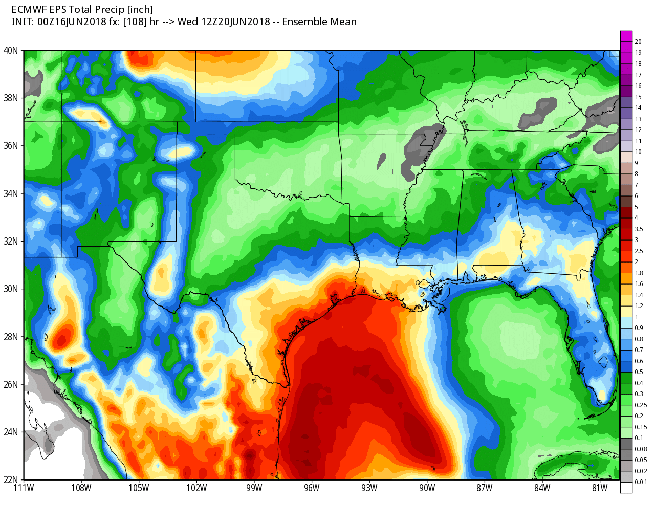
As the disorganized tropical system over the southern Gulf of Mexico gets closer to land, we’ll see increasing winds, and tides increasing a foot or so—but neither of these should pose any kind of significant threat. The bigger concern remains moisture, as the tropical system pumps it into the coast. However, over the last couple of days we’ve been downplaying the threat of flooding, and we continue to think that will be the case, as the greater amounts of moisture will likely be going into south Texas.
For Houston, then, I think we can expect 1 to 4 inches of rainfall over the three day period, with the potential for some localized, higher rainfall rates that can generate some street flooding. If this forecast holds true, this will overall be a beneficial event, as it will knock our searing temperatures down into the 80s for a few days, and help break an emerging drought over the region.
Matt will be back Sunday morning with an update on weather conditions, just to make sure our “low concern” forecast remains on track.
At least we get some saturating rain out of it.
My plants and I are looking forward to some nitrogen rich water!
I so appreciate your common sense postings. I read it every day. Thank you for all you do.
Bellaire has sent an email to all residents warning them of possible rainfall of 3 inches an Hour!!
Do you concur?
Posted on: June 15, 2018
The City of Bellaire Office of Emergency Management
The City of Bellaire Office of Emergency Management requests that you please remain vigilant over the weekend to the developing weather situation by following local news.
Current National Weather Service models indicate a potential for heavy rains this weekend and into Monday. Sunday and Monday pose the greatest potential for rainfall, with locally heavy amounts of possibly 3 inches per hour.
Those rainfall rates are theoretically possible, I do not think it is accurate to say that “models” plural are predicting them at this point.
Eric, are you telling us that, in all likelihood, the worst, most damaging of the storms are more likely to occur in South Texas, to the SW of Houston?
Oh no, This is extremely concerning to me. Our family has been looking forward to a big international vacation, set to depart Monday morning. This is a very very expensive vacation and many hours have been spent researching and planning it. Now I fear it may be ruined. Escaping the city before landfall is unfortunately not an option for us.
I think you’re going to be fine. Enjoy your vacation.
I do like the 82 F high Wunderground is forecasting for Monday. Give the A/C a break.
I feel ya. I live in an airstream, so the AC runs allll day struggling. Yay for cooler weather!
For some time, I’ve been fed up with the inaccuracy, hype, and god-awful webpage design of the mainstream weather sites. This is my permanent go-to site for weather now – your coverage this past week sold me.
Thanks john!
Eric…your and Matt’s vigilance, dedication and easy to digest reporting is greatly appreciated…comforting…thanks!
Thank you for taking the time in the weekend to keep us posted…Happy Father’s day to both 😊
I’ll be flying home to Houston from Chiapas, Mexico on Sunday afternoon/night and I’m an anxious flier, so reading about all the tropical stuff going on right now in the Houston area as well as southwestern Mexico area has me really nervous. Do you think this tropical rainfall will affect flights at all?
I would not rule out delays during periods of heavy rain. But I do not think there will be significant cancellations.
Eric, you and Matt are the absolute best, absolutely the best, thank you! We are so very fortunate to have your amazing knowledge, scientific minds, and down right nice folks, You are the best Houston has to offer. I don’t believe we can say thank you enough, but I’m pretty sure we will try to thank you as many times as we are able to:@)
I’m seeing in some long-term forecasts the potential for lingering chance of thunderstorms through the middle to end of next week. Are you concerned at all about the rain sticking around long long enough to accumulate totals that would cause larger flooding of concern?
For folks going to the beach you might want to mention the forecast for increased/stronger rip currents.
As for rain in my area (Champions in NW Houston), NWS has reduced the forecast for rain from 3.5″ down to around 1.75″ overall, which is fine with me. The lawn is parched and I’ve been holding off on the sprinkler.
Eric et al,
When the term “Inland” vs “coastal” where is the line of seperation. Is Ricmond, Sugar Land area considered inland
My personal definition is based on Counties. Galveston, Brazoria, Matagorda, etc. are coastal areas. Ft. Bend, Harris, etc. are inland. Not sure how this matches up with NWS but it seems to be a good guide.
Coastal is generally the coastal tier of counties and SE Harris County. For example, I would consider Hobby Airport to be straddling the line of coastal vs inland. Sugar Land I would consider inland.
Thanks everyone!
And an oldie but a goodie
Should Katy evacuate
A substantial portion of Katy turned out to be in the flood pool.
Maybe time to retire that joke.
If that’s all you have to contribute, please, go away. That immaturity should stay on the chronicle boards. Was hopeful it wouldn’t find its way here.
Furthermore, Rita absurdity aside, plenty of the Katy area was underwater last August.
Are you stating 1-4 inches accumulating over a three day period Sunday Monday and Tuesday? As that is tolerable and welcome but a rain bringing 1-4 inches three days in a row is a foot of rain, which is it? I am stressing out as I feel the forecasters are being nebulous and I have not slept in 2 days on a roller coaster of up and down forecasts. Thank You
The forecast is for widespread 1-4″ totals spread across the entire event. Some locations will likely receive more in less of a time, particularly closer to the coast.
I see NHC has increased development chances to 20% and shifted the track further right than it has been. Do you think that is likely to shift the heavier rains back toward our direction? The last thinking on this I saw from WFO Houston was yesterday when they were looking closer to Matagorda for the heaviest rain.
My husband and I are grateful fans of yours and we read your emails daily. We thank you for all your efforts and rational, even handed reports. It is reassuring to know that if another extreme weather event happens in Houston we can count on you guys.
Gorgeous day in Port Aransas. Nary a cloud in the sky, 15 mph steady beeeze kept us cool. Local forecast suggest a nice day here on Sunday with a few more clouds. Undertow was strong and waves high. I think we’ll be driving in rain back to Cypress on Monday.
Houston is now expecting 3-5 inches of rain according to David Tillman from abc13