After a mostly benign afternoon, with the exception of some street flooding in Galveston, we are back in the thick of things now, as Imelda’s Wednesday night show is underway.
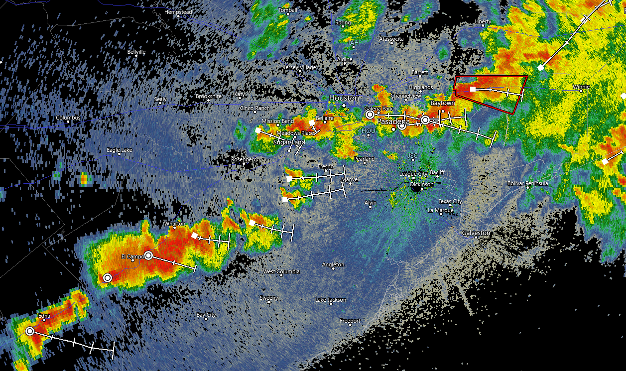
We just had a reported tornado west of Mont Belvieu, and a funnel cloud sighted in Deer Park. Other storms across the area are exhibiting at least some weak rotation, and it would not be surprising to see at least one or two more tornado warnings get hoisted before all is said and done.
We just got this photo of what appears to be a tornado on the ground. Brian Lockwood told us he snapped this near N. Main and 1942 headed towards Mont Belvieu. pic.twitter.com/ipA6S0bAg5
— Brett Buffington (@BBuffingtonHTX) September 18, 2019
Tornado confirmed. This is looking north from Baytown toward Crosby. 📹: Deepa Singh
More to follow at https://t.co/r8H6nC3fG3. pic.twitter.com/B58ijKEdcr
— Travis Herzog (@TravisABC13) September 18, 2019
https://twitter.com/Monsterbuddy__/status/1174449694338113536
In terms of rainfall, a transient heavy rain band is setup along and south of I-10 from near Fulshear through Baytown as of 5:35 PM. That does not appear to be a “training” band at this time, but we’re watching to see if additional development will occur on the western flank. A secondary band is setup over Wharton County moving toward hard hit Matagorda County and parts of Brazoria County as well.
So what are the expectations for the rest of tonight? I’ve tried to digest as much observational and model data as I can, and here are the key bullet points I think we can emphasize.
- For Downtown Houston and points north and west (including The Woodlands, Conroe, Katy, Sugar Land, Kingwood, and Humble): Periods of heavy rain through the night. It may be more dry than wet in many locations, and at this point, I don’t see much reason to be too worried about things in those areas. We will watch late tonight for some heavier rain perhaps in the city of Houston or up toward Spring, Kingwood, and Humble.
- South of Houston (including Pearland & northern Brazoria County) and southeast to Galveston County (Texas City, League City, Webster, and Friendswood): Periods of heavy rain early, perhaps becoming a bit more intermittent as the evening goes on. Given heavier rains here earlier today, some flash flooding is very possible.
- Far south of Houston (Matagorda County, Lake Jackson, Freeport): Heavy rain this evening, with potential for another period or two of heavy rain overnight. Rain totals should be significantly lower than earlier today though.
- Eastern parts of Harris County (Baytown, Mont Belvieu, Crosby): Heavy rain at times this evening, and then occasional periods of rain overnight. More concentrated, heavier rain possible toward daybreak. Flash flooding is a possibility.
- Far eastern parts of the region toward Beaumont (Liberty, Hardin, Chambers Counties east to Beaumont): Frequent periods of heavy rain this evening and overnight. Flash flooding likely in spots. Significant flash flooding possible closer to Beaumont and perhaps points north.
I tried to cover as much as possible there. Folks farther northeast, in San Jacinto, Polk, and Tyler Counties will also see periods of heavy rain tonight and potentially some flash flooding.
Weather modeling has been all over the map in terms of how things finish late tonight and Thursday morning to the point of agitation, to be honest. However, some newer data is indicating that a more concentrated band of heavy rain could develop across Grimes and Montgomery Counties into northeast Harris and Liberty Counties, extending east, again, toward Beaumont. Should that occur, significant rain and potential flash flooding would occur, which could include The Woodlands, Spring, Humble, Bush Airport, and Kingwood. I want to just urge caution on that, as we still have some uncertainty surrounding how that will unfold. We will either update you later this evening or very early tomorrow morning.

Pretty impressive downpour in the Heights this afternoon. The streets didn’t quite flood that I saw but there was a lot of standing water.
I appreciate your breakdown as to which areas should expect what. That really helps!
Thanks for all the info. You are my go to weather source.
Thanks Eric and Matt for the time and expertise you’re devoting in keeping the public updated on this weather system.
“to the point of agitation, to be honest” no doubt. Thanks for the non “the sky is falling” updates.
Thanks so much for your frequent updates. I’m sure this has to be tiring and perhaps monotonous, but you guys really do a bang up job.
As one of the many people who deal with high levels of anxiety (especially brought on by weather related events) I cannot impress upon you how grateful I am for how you relay the weather, and how much I appreciate your timely updates.
Thank you guys very very much.
I’m in Deer Park. A couple of thoughts:
1. Am I Baytown people or Clear Lake people?
2. I totally dismissed the tornado warning earlier. Shocked to see a funnel cloud was over Deer Park! Oops. I’ll be more vigilant next time!
It wasn’t meant to be super specific, nor list every single community, but you’d probably fall under a hybrid of Baytown and Clear Lake for these purposes.
We appreciate any love you give us over here in Beaumont. We know we aren’t your primary market, so we’re grateful. It lets us mix yours with the locals and try to figure out the best. God love us all!
Cypress? My weather station has reported 0.18 inches of rain since midnight and 0.34 inches this week to date… Hardly 3-10 inches we easily need.
Yeah you did nothing to address those of us in the gray area of Pasadena/Deer Park/Galena Park/Jacinto City area. We’re not as south as Pearland, as far east as Baytown or inner city like Downtown. Are we supposed to just assume a little of column A and a little of column B?
You’re a hybrid of A and B, yes. It wasn’t meant to be super specific, nor include every town…just giving you a broad, general idea of what to expect in different sections of the region.
Thank you guys. I’d read the midday report that we were sort of in the clear in the city but I completely get that this storm has been shifty and heat of the day + unstable atmosphere equals the wild west. The rain/thunder/lightning that blew up at 5 tonight just dropped 3.5 inches in 90 minutes, flooding the backyard, but it’s draining at a good clip to the street and has finally stopped for now. I appreciate the guide to what we may have the rest of the night.
Any thoughts on Dickinson? The Bayou is awfully full…
And west of town in Colorado County, nary a drop. Standing at 0.04 inches currently and a little jealous of the rain some are getting. Likely a different feeling than some in the thick of things.
thank you for all you do to keep us informed, eric & matt.