8:00 pm CT Tuesday Update: Our forecast from earlier remains largely on track this evening. We are seeing the threat of heavy rainfall shift from south and central Houston toward the north, and eventually northeast. This is happening as the remains of Beta are tracking toward the northeast. At this time its ragged center is approaching Lake Jackson, and should move beyond Houston sometime on Wednesday morning.
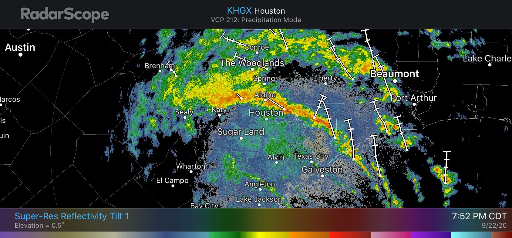
A thin band of heavy rainfall is essentially stretched from Bolivar Peninsula through Baytown, Aldine, and Jersey Village. A few of the strongest thunderstorms in this band are producing rain at 2 inches per hour, but most of the band is dropping rain at lower rates. We are starting to see rises along White Oak Bayou as a result of these rains, but so far it remains within its banks. We’ll keep an eye on it.
These storms should slowly shift north and east as Beta’s center continues to move onward. This threat of overnight rainfall is pretty well captured in the most recent run of the NAM model, which depicts rain totals between 7pm CT Tuesday night and 7am Wednesday morning.
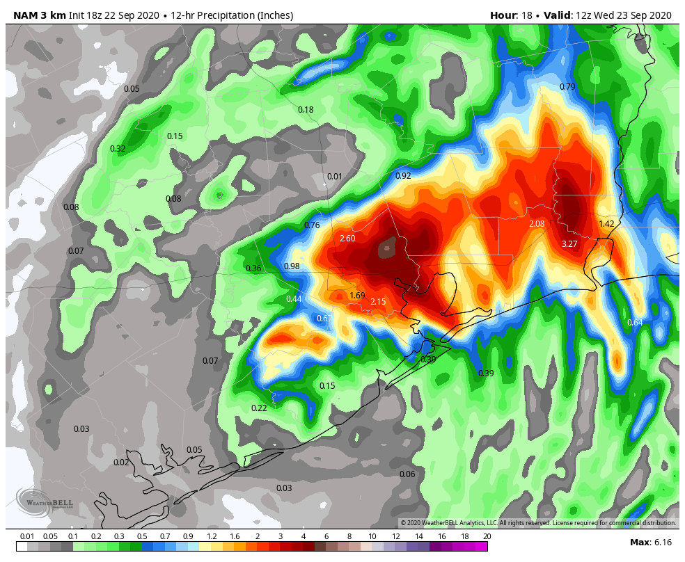
As you can see, we generally expect the areas hardest hit on Monday night—south and southwest of Houston—to avoid a lot of heavy rainfall. The northeast quadrant of Harris County has largely been spared over the last two days, with most areas seeing less than 2 inches of rain. Therefore the potential of 4 to 6 inches of rain dropping tonight north and east of Houston is something those areas should be able to accommodate.
Our best high resolution models still suggest the heaviest rain will push east of Interstate 45 by around midnight tonight, or shortly thereafter, and it should move entirely east of Harris County by around sunrise on Wednesday. The threat later on Wednesday morning will shift into East Texas, possibly including Beaumont and Port Arthur.
The most important message tonight is that if you don’t have to go out, you should remain home. The remnants of Beta will be pushing through the area, and tropical rainfall rates can pulse up and quickly flood streets. So stay home, and wait for better weather tomorrow. It’s definitely coming.
Our next post will come by or before 11 pm CT Tuesday night.

Thank you Space City Weather Dudes for keeping us so well informed! Blessings!
Looking at the radar, once the line lifts north, I’m not seeing anymore yellow’s or red’s. Will we see more yellow and red on the radar overnight in redevelopment?
So glad Beta’s on the move at a quicker pace, but the tight-sphincter pucker factor is engaged here in near-north central Houston. We had water through our house with Allison and Ike, and multiple other times in our garage. We are just a “little” lower than houses around us, which stayed dry. We are near fixated upon the next 6 or so hours.
Which is to say that I join a number of folks who >really< appreciate your updates, having much more than a passing interest in what happens. Thank you, Eric, for knowing we care a lot, and acting accordingly. Solid.
@ MRP, so appreciate your use of descriptive words here. Best of luck through the night!
lol the sphincter mention has me dead 😂😂👏🏼
Having lived through both of those storms as a homeowner myself, I feel your pain. Fortunately, this one is almost over.
White Oak between TC Jester bridge and the pedestrian bridge to Durham bridge is the highest its been all day–we have been taking pics of it all day! When it crosses the berm at the pedestrian bridge we will likely flood….:(
Brays Bayou was wild last night, but never got closer than aprox 8′ to the top of the bank. Even do, at that bright it is an impressive and ominous small river, boiling and churning with a current at least 10mph. With the reduction in rain along the Brays watershed today, it’s drained very well. The flow was down inside the concrete bottom skirt by 6pm.
We seem to have passed the Beta Test…..
What does this mean for Tomball? We closed schools today. Wondering what tomorrow will bring.
Tomorrow afternoon should eventually bring some sunshine!
Pass oir best wishes to Matt Lanza and his recently-augmented family!
wondering the same for cy-fair schools. just want to know if i’ll be going to work tomorrow 😩😩😩
Best weather update and so relatable. Love reading these updates instead of the boring local news ♥️♥️♥️
Thanks Eric for your hard work!
My sleep tonight thanks you for this information. We used to live in a townhouse near White Oak Bayou, and we got flooded twice there (Frances and Allison), so I freak the f out over heavy rain. (My husband is a saint to not have divorced me yet.) So tonight I will go to bed and rest easy, and my husband will rest easy, and it will all be due to you.
Are you looking at Cypress Creek? It’s getting very close in several places. Neighborhood flooding seems increasingly likely Tuesday night and Wednesday.
Thank you for your hard work, long hours and spot on forecasting. It’s greatly appreciated!