A strong cold front pushed through Houston shortly after midnight, and now temperatures have fallen into the upper 30s and lower 40s across the metro area. We’ll now return to a period of mostly colder weather for the rest of January, and early February, with additional cold fronts on the horizon.
Wednesday
While rain showers have not ended this morning, the activity is beginning to wind down as drier air moves in from the west. Overnight totals for most of Houston measured between 0.5 and 1.0 inch of rainfall, but some areas near Magnolia got 2.0 inches or more. This wasn’t enough to cause any major flooding problems, but it certainly made for a wet night. A wintry mix is now falling in a few areas near College Station and Brenham, but it is unlikely to get cold enough in Houston for sleet or snow before the precipitation ends this morning. That should occur between about 9am and noon, as the last rains move east.
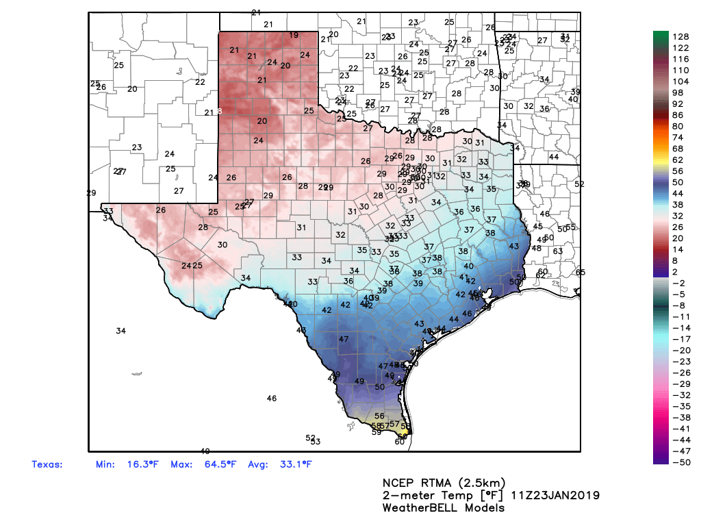
Even with clearing skies, however, temperatures today will struggle to reach into the upper 40s, and with a northerly wind gusting up to 20mph this will certainly be a chilly day across the region. Under clear skies, lows tonight will likely stay at or just above freezing for most of the Houston metro area.

Thursday and Friday
These will be clear and cool days, with highs in the mid- to upper-50s, and overnight lows generally in the upper 30s and low 40s. No weather concerns either day.
Saturday
The weekend should start out with partly sunny skies, however some low pressure may move up the coast, bringing a decent chance of rain showers later Saturday and Saturday evening into the region, especially areas southwest of Houston. Any accumulations should be measured in tenths of an inch of rain. Highs Saturday will likely be in the low 60s.
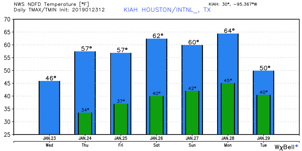
Sunday
For now, this looks to be the better weekend day for outdoor activity, with mostly sunny skies, low rain chances, and highs in the 60s.
Next week
Monday will see a brief warm-up—highs might get into the 70s—before the next front sweeps through to bring cold conditions for most of next week. At this point the front looks mostly dry, but it’s just not possible to say for sure right now. A light freeze is possible in the Wednesday morning time frame, but most of Houston will probably stay above freezing.
Did y’all think it would rain for several hours with this one? I didn’t expext 6+ hours. Seems like it expanded the closer it got to Houston.
A firend of mine who retired out west of College Station texted me saying he is getting something that looks like a cross between sleet and snow this morning.
Do you have any sense of the timing for rain on Saturday? I’m planning to move Saturday starting at noon, and curious if the rain will stay away.
At this time the better rain chances appear likely during the afternoon or later.
I live in the First Ward and small ice pellets were coming down on my car. This was at 9:30 am.
I was driving on I-10 inside the loop this morning and had sleet and some snow flakes (very few) mixed with rain, a true wintry mix!
Should we aim to cover or bring in plants with the overnight lows on Wednesday?
why not
It’s currently hailing/sleeting/snowing in Webster, Texas.
It sleeted from Needville to El Campo from 830 to 10ish this morning