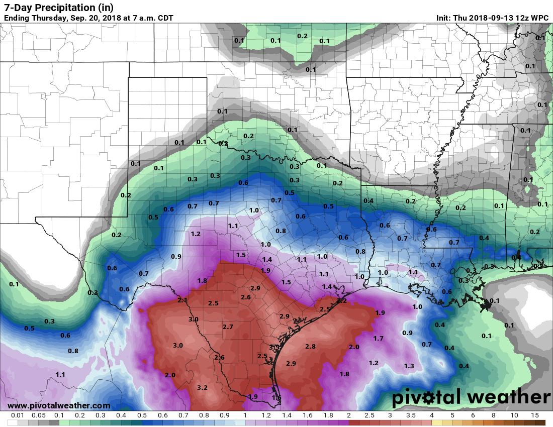
As we’d hoped, the radar has generally been quieter this morning across the Houston area, with showers neither as intense or widespread as they’ve been over the previous two mornings. And while we’re not out of the woods in terms of heavy rain and street flooding potential, we can at least see a period of sunnier weather in the distance.
Thursday
The southern half of the Houston area remains under a flash flood watch through Thursday evening, and this is primarily because of already saturated grounds due to a very wet week for the coast. Generally, we don’t expect coastal areas to pick up more than an additional 0.5 to 2 inches of rain during the next 24 hours as moisture continues to stream inland. This should be manageable, but we’re definitely watching several bands of stronger showers just offshore that could move inland.
Friday and Saturday
The oft-discussed Invest 95L—and there really has been a lot of sound and fury for a tropical system that never really has appeared all that threatening—will continue to move toward the Texas coast, and should come inland Friday. The threat from this storm will be heavy tropical rainfall, but as the system remains disorganized, it shouldn’t be that potent of a rainmaker. Some areas along the Coastal Bend may see upwards of 3 to 5 inches of rain over the next few days with some higher isolated totals, but in the Houston area I expect the coastal areas to hopefully see less than that, and inland areas perhaps 1 inch of rain through Saturday.

Sunday and next week
By Sunday, or so, we should transition into a much more late-summer like pattern of partly to mostly sunny skies, with a chance of scattered, afternoon thunderstorms. The sun’s return will lead to warmer weather, so we can probably expect high temperatures in the low 90s. If you’re wondering when that first fall front is coming, so are we. It appears unlikely over the next week or 10 days, but by the last week of September the models are hinting that change may finally move into the region. We can hope.
Tropics
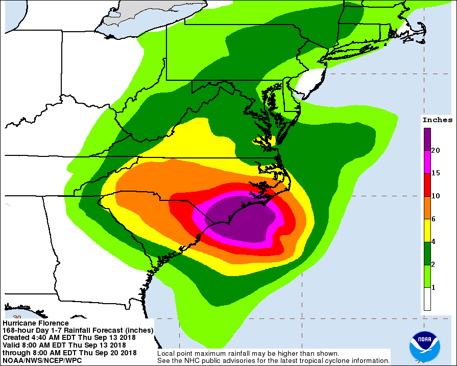
Hurricane Florence is about 24 hours or so from making landfall along the North Carolina coast. Although it has “weakened” to 110-mph winds, a massive storm surge is already baked into the Atlantic, and Florence will bring devastating inland rainfall to the Carolinas this weekend.
Meanwhile, Tropical Storm Isaac is about to move into the Caribbean Sea. It most likely will weaken into a remnant low over the next two to three days due to wind shear. We’ll continue to monitor Isaac over the next week or so in case the storm finds more favorable conditions, in the western Caribbean, regenerates, and moves into the Gulf in several days.
As long as the light at the end of the tunnel isnt the train I’m happy. ❤️
Hahaha
That light may be a train named Isaac.
300 cubits by 50 cubits by 30 cubits………..
What the heck is a cubit, anyway?
Hahahaha, I used to laugh at that skit so hard! “NOAH!” “WHAT????”
ding! NOAH!
WHAT?
How long can you tread water? Ha Ha Ha Ha.
When your pop culture reference is 50 years old….😜
My favorite line was “No, wait, I’ve got a better idea. Let it rain for forty days and forty nights and wait for the sewers to back up”
The Torah’s cubit is the equivalent of 18″ or according to some authorities, 24″. #staydry
A cubit is the approximate length of a forearm, or about 18 inches. A long cubit is about 24 inches.
A cubit is about 18 inches. Roughly the distance between your hand and elbow.
Are these storms slow moving? It seems like we have been watching Florence and Isaac for An extended period of time.
Both of them formed well out in the Atlantic. Both have moved slowly at parts of their lives, but not for very long periods. Indeed, Isaac has been moving in excess of 20mph recently. They’ve just had a lot of real-estate to cover.
Not looking forward to going back to temps in the 90s.
Eric, The news today got me thinking. Isn’t it short sighted for the “strength” (category) of a hurricane to be measured solely by wind speed. I consider 3 major elements to a Hurricane; wind, surge and rainfall. Now that Flo is 2, I can already see some reports calling it weakened and de-emphasizing the danger but the rain and surge are as potent as they were any time this week.
If category of the storm is correlative to people’s attention to it, shouldn’t category of a storm be determined by more that the maximum wind speed?
I am very curious to hear your thoughts.
Yes, it should. There was a focus on this issue after Ike (2008) and Sandy (2012) to incorporate storm size into these rankings. Ultimately, it was shelved in favor of retaining a simple metric that public could comprehend.
Maybe they need to be labeled like bags of fertilizer… For example, 2-3-3 for Wind-Surge-Rain.
So this got me thinking. If the numbered categories are what is important, why not create the Hurricane Severity Scale with the same 5 numbers? Such a scale could take into account winds, wind radius, speed of motion, and any other relevant factors. Such a scale would, for instance, have Ike and Florence as probably cat 3-4 at landfall. Harvey could have been a borderline cat 4/5 based on the rainfall potential. Katrina could have remained a cat 5 at landfall under such a scale.
The Euro model updated this morning to show Issac restrengthening and taking a path towards SW Louisiana by the end of next week.
https://www.windy.com/?2018-09-22-18,29.753,-95.410,5
I saw that too… I assumed it was remnants of Isaac (about 21st or 22nd) . Headed to SW La now,but that could change, I saw no High pressure near to steer it away from Texas
This morning the EURO has a Cane or Storm moving into SW La by 21st or 22nd… I know it is too early to tell, but could this be the remnants of Isaac reformed?
Yes, that’s Issac still. I wouldn’t put much stock in it at the moment. The storm has to survive the next few days still and we’ll see whats left.
Yes, the remnants of Isaac is what the Euro operational model is showing. But please bear in mind this is 10 days from now, and should be regarded as a very low confidence forecast. We’re watching this, but urge you not to be particularly concerned.
Great! thank you for responding and ALL that you guys do!!!!
I’m trying to not be too concerned, but having a hard time about it. I remember 10 years ago seeing similar statements about not needing to be concerned about Ike. And Harvey became a strong storm after having dissipated and then re-formed once it moved into the Gulf.
This is why Eric and Matt keep saying they will keep monitoring conditions. I have found with this site that if something looks like it could change, they will update their forecast. Until then, the old statement from the Ziggy cartoon applies (if anyone remembers Ziggy). “Worrying is like sitting in a rocking chair. It doesn’t get you anywhere but it gives you something to do.” Don’t worry but keep checking.
Ike did something very unusual. There is a rule of thumb that says stronger storms go north. Ike was one major exception to that rule. As a major hurricane, probably over a thousand miles from Florida, his track got bent back to the southwest. Once that happened, the Gulf did come into play. Betsy did something very similar to this, twice.
The Caribbean is frequently hostile to tropical cyclones. 2003’s Claudette had tropical storm strength winds all through the Caribbean but could never develop a closed circulation until the NW Caribbean. She was intensifying quickly as she approached the Texas cost.
Isaac is something that bares watching, but is not something to be too concerned about at this time. We have 10+ days to get an idea where he’s going. (Yes, I know I just repeated what Eric said.)
Quick thank you for your no hype weather forecasting. You won me over ten years ago with your forecast regarding Hurricane Ike.
As a born & raised Houstonian who’s been in Charlotte for 13 years, not only do I appreciate your daily Space City Weather – keeps me connected to precious family & friends – but thank you for including Florence, well beyond your “coverage” but part of the overall weather story. Thank you for all you two do! Wish we had such a service here. Y’all are amazing!
The whole media industry could take a clue from Eric and Matt. No hype, straightforward and honest. It is great to see they are gaining a following by using these attributes versus the hype we have all grown tired of…weather, politics, etc. It’s like they are winning by reporting the facts and being genuine in their opinions…go figure.
Driving in this morning, the Houston Metro traffic signs said “Storm Forming in Gulf”. Referring to 95L. (Big Sigh…)
Having recently subscribed to your e-mail list, I want to Thank You (-All) for your direct, concise, “no beating around the bush”, Non-extraneous, Non-hype weather reporting!! I used to be ‘tuned-into” t.v. Weather-Reporting. Gave that up after ‘Harvey’.
Thanks again for your ‘style’ of giving Information. Keep up the Good work!,
L. Dacy
I saw that too. Scared me. Not cool.
It would be ironic if an Isaac and an Ike both hit Houston, wouldn’t it? double whammy.
Thanks Eric. As another reader mentioned, you won me over during Ike.
The NCH has Hurricane Florence turning sharper to the Northeast. Will this have any effect on Isaac’s path?
Again, thank you so much for these concise reports that give us great information! It is so calming to read the “facts”. I prefer reading so I can absorb the material. I read daily to give me a true, scientific view of what’s going on. Just can’t say it enough-thanks for being there and for all that you do!