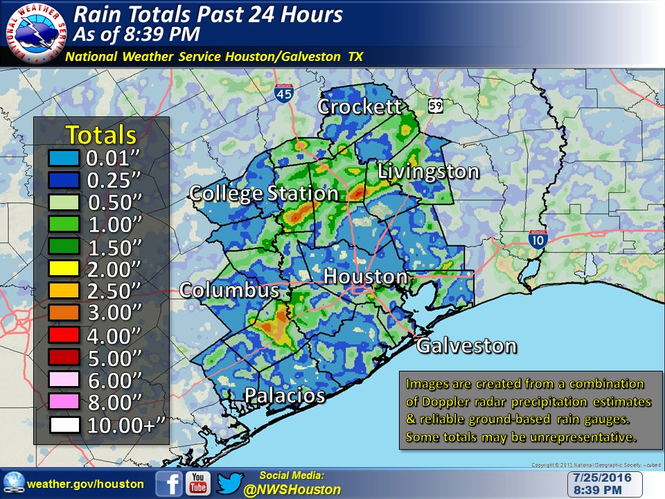
Good morning. After a wet Monday brought as much as 3 inches of rain to some of the Houston metro area (see map below), it looks like we’re in for part two today, with lowering rain chances through the rest of the week.
The upshot of this is that the region could really use the rain after a very dry month of July.
Today
As of 6:15am CT rain showers have spread over most of the western metro area, south of Interstate 10. Northwestern Fort Bend County is already under a flood advisory for minor street flooding due to these rains, and there may be some delays along low-lying roads.
It looks like the greatest amount of moisture today will be closer to the coast, leading to greater rain chances for those areas, and less further inland, for Montgomery County and to the northwest of Houston. Additionally there is enough moisture to produce some locally heavy rainfall, although I am not expecting any significant problems. Overall I am expecting a day similar to Monday—with some areas receiving 2-3 inches of rain, and other areas getting perhaps a tenth of an inch. On Monday the rains didn’t start until later in the day so high temperatures still had a chance to rise into the upper 90s for most areas. Today, with earlier rains, I expect highs to remain confined to the low 90s.
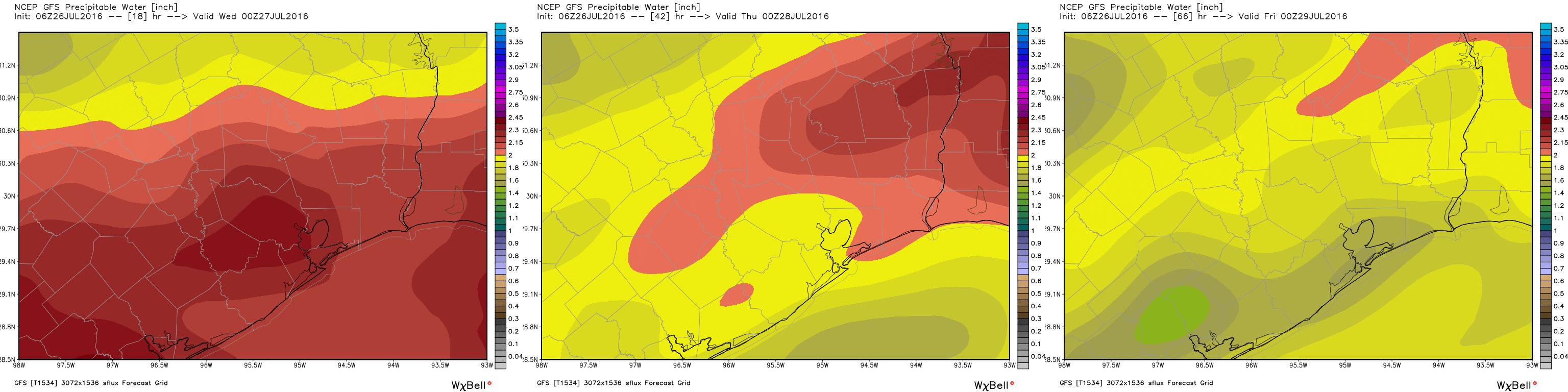
Wednesday
Widespread rains remain possible, although moisture levels in the atmosphere will fall back a little bit. Therefore I expect less accumulation and less coverage—with the most likely location for better rain chances further inland.
Thursday through Sunday
Houston will fall back into a more typical summer time pattern toward the end of the work week, although reasonably healthy precipitation chances will remain in the forecast for some time because high pressure isn’t going to entirely dominate our weather. That is to say we’re going to see highs in the low- to mid-90s, with a 30 to 40 percent of showers, mainly during the afternoon and driven by the sea breeze. It beats 100 degrees and near zero chances of rain, which is often the case as we begin August.
Posted at 6:35am CT Tuesday by Eric
Well, once again, we did not get the rain here right by hwy 59 and San Jacinto river. What we did get was a 3″ “rain”…. A drop every 3”! Just raised the humidity enormously. Fingers still crossed…we washed 2 cars and my son put down sod a few weeks back. Hmmmm, maybe it is his fault! Eric, can you explain why the rain is so spotty? Is there a trigger or something?
There’s just not an area-wide forcing, like a front or a broad tropical low pressure system, that is going to bring rainfall across the entire area. Because of this we’re seeing more spotty rain and some areas are getting a lot, and others not so much.
It’s actually northeastern and not northwestern Fort Bend County, according to the flood advisory link.
Sorry, Eric but in most recent models, it appears that someone took a flyswatter to the
vort max associated with the incoming TUTT and splattered it all over our coastal area. The the weakness in the ridge aloft remains, leaving the Houston area in a cool area between ridging to the east and west. This likely will create a repeat scenario tomorrow, particularly if we do see a focusing boundary again. Storm motion should again be slow, and will result in continued potential for localized storms with heavy rainfall.
Bottom line: Wednesday will be a clone of today. If you didn’t see any high winds, frequent lightning, or heavy rains where you live today, you probably will Wednesday. Stay tuned!