As Matt so accurately wrote on Friday, a “second summer” has descended upon Houston. It will reach its peak this week, and conditions will be pretty brutal for late September, with high temperatures nearing or possibly surpassing 100 degrees. The good news is that we do see a light at the end of the tunnel, with the potential for a decent cold front pushing into Houston next week. This is not something we can guarantee yet, but I would say that if you can hold on for about one more week of Houston summer, we probably should start to transition into more fall-like weather soon.
But yeah, this week is going to be brutal.
Monday
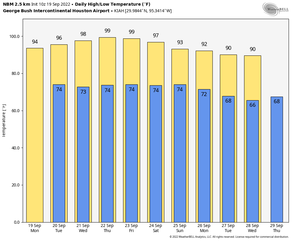
Today will bring more weather like we experienced on Sunday, with mostly sunny skies and highs in the mid-90s for much of the region. We will again see the potential for some isolated to widely scattered showers, with chances only in the 20 percent range for coastal areas, and perhaps 10 percent for inland areas. Winds will be light, out of the east at 5 to 10 mph. Lows tonight drop into the mid-70s.
Tuesday, Wednesday, Thursday, and Friday
The middle of this week will be hot, hot, hot. High pressure will dominate our weather, and this is going to drive temperatures into the upper 90s and possibly 100 degrees for areas well inland. Thursday looks like the hottest day of the week. There is no way to sugarcoat what is going to be anomalously warm, potentially record heat for late September. Rain chances will be near zero after Monday.
Saturday and Sunday
High pressure starts to back off some this weekend, but I think we’ll still be solidly in the mid-90s in terms of temperatures, with mostly sunny skies. Rain chances remain fairly low, but it’s difficult to rule out precipitation this far out.
Next week
Much, but not all, of the model guidance shows a pretty decent cold front arriving in Houston next Monday or Tuesday. This is far enough away that we cannot fully buy into it yet, but at this point I think the chances are better than 50-50. This front has the potential to drop highs into the 80s, and lows into the 60s, and could be strong enough that I’d classify it has Houston’s first “real” front of the season. We should have a more definitive answer on the front in a couple of days, and obviously we’re watching it closely.
Tropics
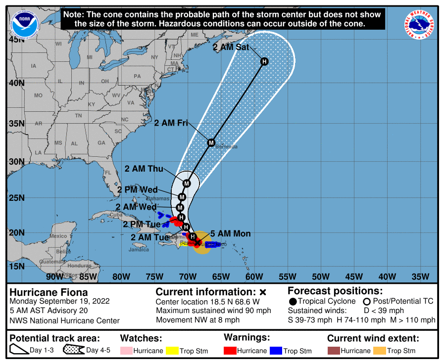
Hurricane Fiona, with sustained wind speeds of 90 mph, ravaged the island of Puerto Rico this weekend, knocking out power to the entire island and dropping 1 to 2 feet of rain. The US territory will need our help in the weeks ahead. The storm is beginning to turn northwest, affecting the Dominican Republic, and will eventually turn northward and threaten Bermuda.
Beyond Fiona there’s not much to write home about. We are getting close to the end of the Texas hurricane season, but I’m not quite ready to declare it over yet. But soon, probably. Check back Thursday.


Models are picking up a significant tropical wave in the Caribbean. This season is far from over.
If next week’s cold front verifies, than you can stick a fork in Tx Hurricane season ’22.
What is the last day in September that a tropical system has ever impacted the Texas Gulf Coast? I think it’s the 27th or 28th.
Nope. A full Hurricane (Jerry) hit in October 89. That’s not necessarily the latest one has impacted us though either.
The last several seasons have been very Gulf-centric, it was a near miracle we didn’t get our heads kicked in 2020.
This season, we’re getting the year off it appears.
We boarded up and evacuated to Dallas in August 2020 when it looked like Hurricane Laura was going to walk its way right up the ship channel for a few minutes. Glad that ended up being a miss.
Laura caused a fair amount of damage at Surfside Texas
Global warming strikes again. It caused a hot June, a mild August and now a hot September with tons of hurricanes, just like the climate experts predicted.
Umm sir, this is a Wendy’s
um sir, this is a Wendy’s
Ma’am, this is a Wendy’s.
A cold front next Tuesday would be the perfect birthday gift!
Happy Birthday, Sheri.
These late season High Pressure Ridges develop because?…..We have always had atmospheric high pressure, but why do some get so dominant as to cause Heat Waves? The reverse question would be…why do some years have delightful cold fronts in mid-September while other years have almost none? As far as heat is concerned in Houston, 2022 is certainly a year for the record books.
New baseline?
I dont want cold. Summer is good!
Does anyone track “hurricane predictions” seems like they are a lot like stock market predictions!
“The outlook from NOAA is for 14-20 named storms predicted this year, with 6 to 10 of those becoming hurricanes and 3 to 5 major hurricanes.”
“On June 2, CSU researchers increase their forecast, calling for a “well above-average” 2022 season. The team now predicts 20 named storms, including 10 named storms, of which five are forecast to be major.”
I just saw a gfs run a few minutes ago, for a strong hurricane to hit Texas October 3-4 timeline….That’s when I fly out to go see family that I haven’t seen in 3 years…Now I have to rely on accurate weather forecasting to reschedule or cancel in time..My crappy luck…
Long range forcasts 2 weeks away are not 100% accurate.
Totally agree, Tom. Make you plans and readjust if necessary. I for one, suspect that the Long Range Forecast for this year was a complete miss, I would be quite surprised to see us get hit with a major storm this year.
Yes, I’m hoping too…I know that two weeks is far out for even a tinge of accuracy…I’m just disappointed that I have to watch this particular two week window very closely…Oh man, I thought I was planning my trip well..I had the mistaken impression the CONUS would have it quiet for the next two weeks at least, as far as waves crossing the Atlantic…
“Beyond Fiona there’s not much to write home about.”
And like clock-work there’s news about potential issue in the Gulf for the next 10 days. I’m starting to think forecasting is nothing but dressed up guess-work and little else.
He did mention he wasn’t quite ready to declare Texas closed to hurricanes for the season, even though he was close..I wonder if he saw some of these models already..