Autumn is really just a state of mind. In Houston it has to be because you certainly would never know it was just about autumn by stepping outside. The high temperature on Thursday was 99 degrees at IAH Airport. Hobby managed to hit 96 degrees. This heat will continue.
Today and weekend
Expect mostly a rinse (without the water) and repeat weekend of weather here in southeast Texas. We will have sunshine and heat. High temperatures should flirt with 100 degrees each day for Houston and points north and west. Coastal locations should top off in the mid-90s. Morning lows should be in the mid- to upper-70s. It may be a degree or two less hot on Sunday.
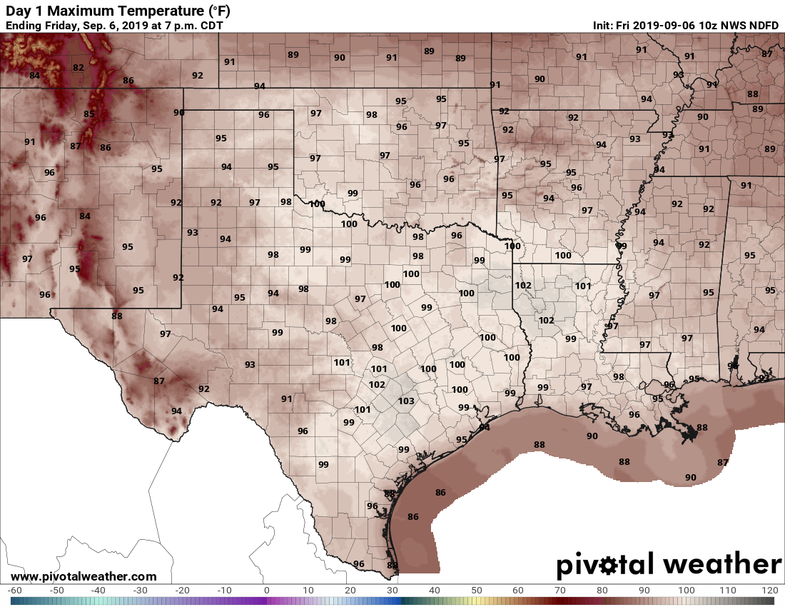
As Eric noted yesterday, we will definitely have a good shot at tying or breaking some long standing record high temperatures today and tomorrow. Sunday will still be possible but probably a bit less likely. The records:
Friday: 99° (1909)
Saturday: 98° (1963)
Sunday: 100° (1907)
Stay cool and do your best to conserve energy, particularly today.
Early next week
The dome of high pressure responsible for our surge of September heat is going to migrate off to the east next week. It won’t be far enough away to allow any kind of meaningful cool air to drop through the Plains, but it should be enough to at least allow sea breeze showers each day off the Gulf. This would be of the 20 to 30 percent chance variety. I would expect mid-90s each day, along with a bit more more humidity.

Late next week
Forecast confidence obviously diminishes for late next week, but we see a couple trends. High pressure over the Southeast may actually try and backtrack toward us once again. Should that occur, look for diminishing rain chances and a return of mid- to upper-90s days. I wish we had better news for those seeking a cold front. It’s just not in the cards for at least the next 7 to 10 days, probably longer.
Tropics
Hurricane Dorian’s flirtations with the United States are nearly complete this morning. In the end, there is a chance it will not have made landfall in the Lower 48 at all. Dorian’s eye is just south of Ocracoke Island, NC this morning and will graze or briefly wobble ashore at Cape Hatteras in a few hours.
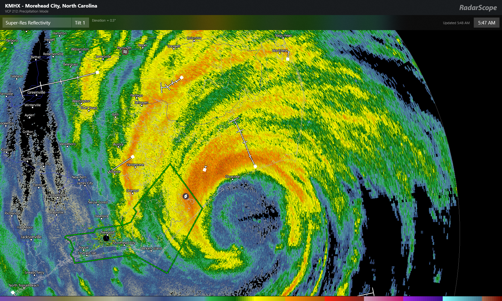
From there, Dorian will march out to sea but likely slam into the Canadian Maritimes on the way. Hurricane watches are posted for Nova Scotia, and tropical storm watches are posted for Prince Edward Island and Newfoundland.
Elsewhere, the next disturbance to watch is newly designated “Invest 94L.” That one takes a track across the Atlantic to the west, and it should arrive in the Lesser Antilles in a little over a week. Most modeling indicates that this disturbance or one behind it will end up somewhere in the western Atlantic, be it heading out to sea or perhaps off the East Coast in about 12 to 14 days. There is no reason for us in Houston to worry much about this one right now. We will let you know if that changes.
The way the weather patterns are and have been most of the summer, unless some “front porch” activity develops, Alicia or Harvey for example. Our Hurricane season may already be over. Your Thoughts.
Thank You.
It ain’t over til it’s over. Still have 3 weeks left of true Texas hurricane season, then odds historically drop dramatically. I think overall we might be safe from deep Atlantic stuff, but I never want to let my guard down too soon.
It’s not over until the fronts start rolling through. They clear the gulf, no fronts- well the door is wide open.
Whatever happened to the “Bermuda” high pressure system that we used to hear about?
I wouldn’t mind a low pressure system if we could get rain. We could really use some.
It’s still there. I’ve mentioned it once or twice this summer. It’s just not as prevalent as usual, or at least not as significant for us this summer. Most of our heat ridges have built overhead or just to our north.
Is the “drought” determination a standard measurement? I lived in desert states most of my life and we would go months without rain. Never heard the “drought” word more than I have since I’ve lived in Houston.
I also lived most of my life in the desert. A region is in a drought when it falls below a certain level of precipitation over a certain length of time relative to what the region is supposed to receive. In the desert, this time frame is much longer because the region is, as you said, used to receiving no rain for months. In Houston, where it’s possible to get a years worth of desert precipitation in a week, the cycles of drought become much more pronounced and (potentially) frequent as the lack of rain has an immediate affect on the region. So yes, drought is a standard measurement for a region, but it’s not the same everywhere.
Not sure if you are just poking fun at our media coverage but just in case here is what you seek:
https://www.livescience.com/21469-drought-definition.html
It’s based on local soil/water climatology I believe. The definition here focuses on what is relative to normal. We’re just more drought prone than the desert because the desert is climatologically dry. Here, we average a lot of rain per year, so it’s easier for us to slip into drought. They explain more here: https://droughtmonitor.unl.edu/AboutUSDM/AbouttheData/DroughtClassification.aspx
I’m more than ready for some Decembrrrr myself.
I may be the only person that feels this way, but I LOVE THE HEAT, and I love knowing no rain is going to flood us right now! AND we still have 17 days left technically of summer!
🙂 The population of the greater Houston area which includes nearby counties and suburbs is about 6 million, give or take. Absent the invention of air conditioning, and it might be 6 thousand. 🙂
Ah yes, the growth of the Sunbelt was driven by the improvements in air conditioning. As a history teacher by trade, we cover this every year in U.S. history 🙂