Good morning. Houston is seeing warm and humid conditions this week, as one would expect in June. However, we still have a ways to go in terms of summertime heat, and the region should reach the mid-90s by Saturday. The question remains about what happens after that, and it almost entirely depends on what happens with Tropical Storm Cristobal. At the moment, it still appears as though the storm and the bulk of its effects will probably stay east of Houston, but we’re far from being able to make a definitive call on that.
Wednesday
Today should produce the region’s best chance of showers and thunderstorms until at least Sunday. A combination of daytime heating, ample moisture in the atmosphere, and only moderate high pressure should allow for some storms to fire up this afternoon before fading this evening. High resolution models offer a mixed bag of solutions, bit given our recent pattern I’m fairly bullish on at least some moderately strong storms firing up closer to the coast and pushing inland later today. Areal coverage of these storms will probably be in the 30 to 50 percent range, so not everyone is going to get wet. Otherwise, expect partly sunny skies with highs of about 90 degrees.
Thursday, Friday, and Saturday
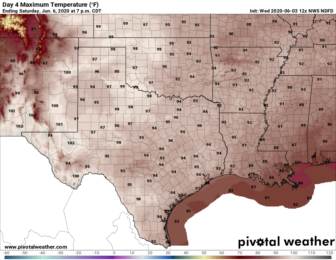
As high pressure settles into the area we should see a warming trend, with partly to mostly sunny skies through Saturday, and highs rising into the mid-90s. Under such a pattern we normally would expect only slight afternoon rain chances along the sea breeze.

Tropical Storm Cristobal
Our weather will start to become influenced by Cristobal on Sunday—one way or another.
The storm has intensified over night, reaching sustained winds of 60 mph in the Southern Gulf of Mexico. However, that pattern is likely to reverse itself over the next day or so as the storm’s center has moved into the Southeastern Mexico coast. During the next 24 to 48 hours Cristobal will continue to produce life-threatening flooding over parts of Mexico and Central America before finally beginning to move northward sometime on Friday. The storm will get captured in a steering flow around high pressure anchored over the Southeastern United States.
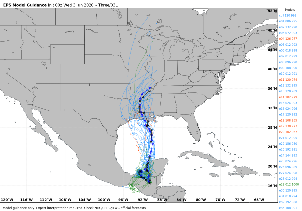
It remains to be seen how long Cristobal’s center moves over land, but by Saturday some sort of tropical system should emerge into the central Gulf of Mexico, heading toward the north or northwest Gulf of Mexico coast. The vast majority of ensemble members of both the European and GFS models continue to bring the center of the storm ashore somewhere between Houston and Southern Mississippi between later on Sunday and Monday. We are still five days out so significant changes are possible, but confidence is increasing.
The important thing to note about this system is that it will likely produce the bulk of its impacts to the east of the center—so a landfall to the east of Houston means our region likely will not see significant impacts. If that happens, we probably will see continued hot and at least partly sunny weather into early next week on the back side of Cristobal. If the storm comes closer, or over Houston, obviously, rain chances will shoot up. However, even if that happens, the storm’s movement should be progressive enough that will will not see days of heavy rainfall chances.
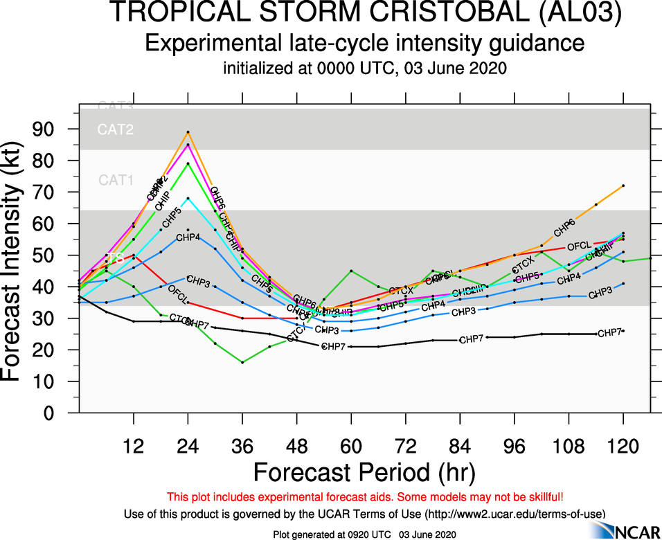
In terms of intensity, that outlook remains fairly uncertain. The National Hurricane Center is pegging landfall intensity along the northern Gulf of Mexico coast for Cristobal as a strong tropical storm, but this is going to depend on the extent of weakening over the next day or two as Cristobal wobbles inland in Southeastern Mexico.
The Houston/Gulf Coast Region is unbelievably fortunate to have Mr. Eric Berger as our premier weather expert. There is no-one better or more reliable. Thanks for this comprehensive, plainly-stated and knowledgeable update on the first potential storm of the season. it’s great to have Mr. Berger to rely upon.
I greatly appreciate and value your forecasts. I understand the greatest impacts will be to the east of the area of landfall, but would appreciate your sharing your thoughts as to what the tidal levels will be in the Houston area before, during and after landfall, assuming the storm remains on its predicted path toward landfall to our east.
Many thanks to both Eric Berger and Matt Lanza for the continued solid hype-free weather reporting!
If this storm tracks east, I won’t object but I’d like to get some cloud cover (with no rain) just to hold down the temps.
Eric – your “Cristobal Crystal Ball” pun in yesterday’s post was worthy of Stephan Patis (creator of the comic strip Pearls Before Swine – for those who don’t know).
Dang – I meant Stephan Pastis.
I’m sure Stephan Patis will forgive you. 😏
I’m so grateful for your careful, hard work. You guys are awesome. Thanks!
Thanks for keeping me relatively calm at this time of year. I refuse to watch any other weather forecaster because some of them are alarmists and it isn’t helpful as I can do that all by myself!!!
Thank you for your great analysis. I read your post everyday as part of my routine.
Sometimes I read the comments just to enjoy how appreciative and friendly they are. This must be the most gracious place on the Internet.