Good morning. We’re approaching the longest day of the year—June 20—but we’ve already reached the earliest sunrise of the calendar year for Houston. From June 3 to June 17, sunrise will occur at 6:20 am CT before it starts to get later. Our sunsets will continue to get later until July 2. (Why is this? Well, it’s a bit complicated). Weather-wise, we’re looking at a lot of sunshine in the week ahead as long as Tropical Storm Cristobal stays east of Houston, which is looking increasingly likely.
Thursday
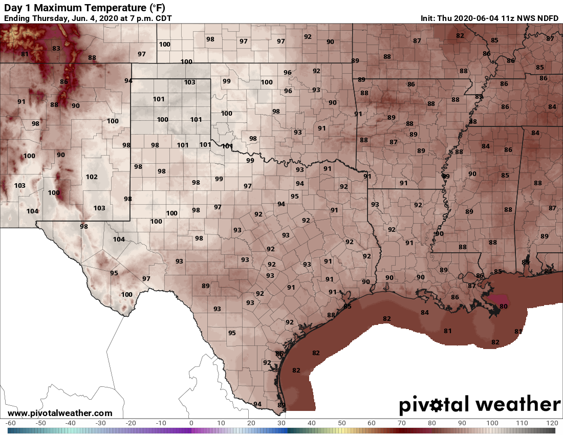
We should see partly sunny skies today, which will allow high temperatures to nudge up to 90 degrees or slightly above. Some showers and thunderstorms will be possible today, but they’re not going to be as organized as we saw on Wednesday. Some models are hinting at the best chance of rain between Houston and Beaumont, but even then it’s a really scattered shot at showers. Most of us will just be dry and hot, with light winds out of the southeast.
Friday
Expect a similar day to Thursday, although perhaps a touch warmer. We expect to see high pressure building in from the west—the same high pressure that will probably help steer Cristobal east of the region—and this will set the region on a warming trend into the weekend and likely beyond.

Saturday. Sunday, and beyond
Right now the forecast for this weekend, and beyond, is mostly sunny weather with warm days likely in the mid-90s. If the current forecast holds, we may see some showers from Cristobal on Monday, but even that may be a stretch. Most of the next week looks really hot for June, with highs potentially in the upper 90s.
Tropical Storm Cristobal
The storm’s center has been inland, over Southeastern Mexico, for about a day now and this interaction with land is showing its effects. Winds are down to 40 mph, sustained. In about a day or so, Cristobal should begin to lift north, and begin accelerating toward the northern Gulf of Mexico coast. Due to this prolonged interaction with land, it seems likely that no more than a tropical storm will have time to redevelop over the Gulf, with a final landfall likely some time late on Sunday or Monday.
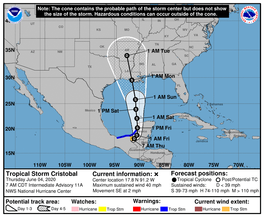
Louisiana remains the most likely destination, and as we’ve been saying, nearly all of the wind and rain should be to the right side of the storm. So even if the center makes landfall in Lake Charles, Houston likely will see only very moderate effects, if any. (The heaviest rainfall now looks most likely over Southern Alabama and the Florida Panhandle). Should this forecast thinking change, we will of course update the site.
Thanks for the link to the explanation about the sunset. I was just on timeanddate.com looking at their sun calculator last night and wondering about this. Great timing!
Thanks so much for info.scares me so since my house was destroyed by harvey,just moved back in sept.2020,I just fear so much of bad weather,I pray alot,thanks again
Oh we are so happy Cristobal is going away. My dear Fulgencio weeps with sad memories when he hears that name. I dread the coming of Gonzalo I do not know how I will be able to comfort him it will be so much teary!
Heat good, tropical storm (or worse) bad. I’ll take the heat