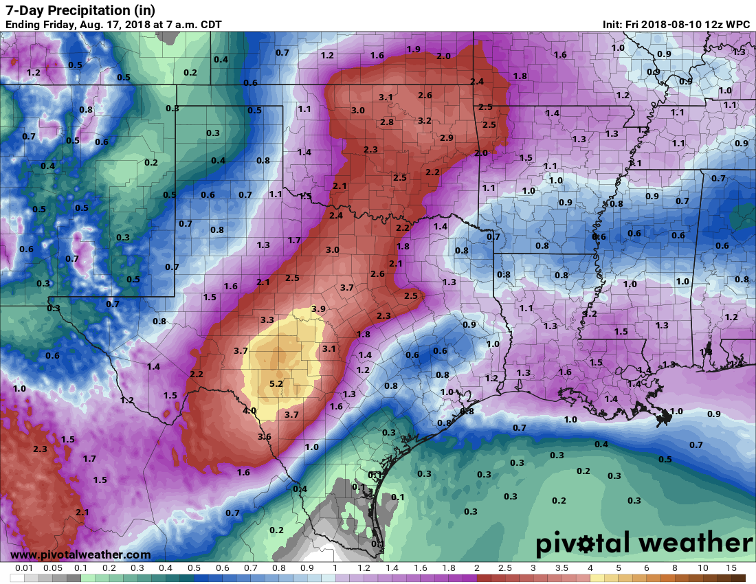
Sorry for the delayed post this morning, but sometimes things happen. Fortunately, the forecast has not changed too much, with the potential for showers and thunderstorms both Friday and Saturday before a decreasing chance of rain Sunday, and drier conditions early next week.
Friday
Expect a stormy summer day. Most of the ingredients needed for rainfall will come together early this afternoon, with ample moisture, lift, and instability across the region. Some of these storms could produce locally heavy rainfall, and we can’t rule out some street flooding. However, I expect that most areas that do see rain will probably see about one-half inch. Highs will probably be in the low 90s, but local conditions will vary on the amount of cloud cover and rainfall. Rain chances retreat, but do not go entirely away, tonight.
Saturday
We expect to see similar conditions on Saturday, with moisture and atmospheric lift driving another round of (probably) widespread showers. These will not be all-day storms, but certainly they will have the potential to move through and disrupt any outdoor activities. High temperatures, again, will be dependent upon cloud cover and localized rainfall.

Sunday
As higher pressure begins to move into the area, we probably will see a slackening in both rainfall coverage and amounts. Still, there should be enough residual moisture in the atmosphere, combined with the afternoon sea breeze, to pump out some isolated to scattered showers. Expect high temperatures in the low- to mid-90s.
Monday and beyond
High pressure should bring more classic, August-like weather to the region next week. We should expect to see mostly sunny days, with high temperatures in the mid- to upper-90s. The sea breeze may be able squeeze out some scattered showers later in the week, but I’d not be counting on much (if any) rain in the immediate forecast after this coming Saturday or Sunday.
Whew I was getting worried. Don’t you realize that your average age readers here probably woke up 6 hours ago
At 3:30am?
I was shocked at the weather we got last evening in Cypress. Wow! huge winds, hail, downpour and mass lightening and thunder…. Thanks for the update this morning Eric. Have a great weekend!!!!
Dee, send it down this way to the Westchase section of Houston. We have not received any rain!
More like 4 hours for me.
But I’m pretty much incapable of higher mental functions like reading until I drive to the office and get some caffiene in me. So a 9AM posting is just fine.
🙂 Next week = “The Return of the Ughust Monster” 🙂
I was getting worried to, I thought y’all left yet hanging. Love reading your daily post. Could you throw us an extra one one day a weekend maybe. Love it. Have a blessed weekend guys.
“Classic August-type weather…” Makes it sound rather sophisticated, rather than hot as hell 😉 Thanks for the updates.
How will all this rain affect the Perseids? I believe that the peak viewing is this weekend and early next week.
Ah, you can’t see the meteors when it is raining?
Not so much the rain, any cloud cover obscures the meteor shower.
OK….still waiting on some rain around here…
It’s now noon Saturday. Still no rain this week. According to the TV media, I should be treading water by now.
Time to call Honi the Circle Maker?
At 2:45, it’s raining cats and dogs in The Woodlands