Sunday’s strong storms, including some significant straight-line wind damage in parts of Houston and at least one confirmed tornado, heralded the beginning of spring storm season for the region. This period of heightened tornadoes and severe weather typically occurs during April, May, and early June.
The spring storm season typically fades as we get into summer—when dynamic fronts typically end, and high pressure more or less asserts control of our weather. Then, the primary threat comes from the Gulf of Mexico and hurricane season. Speaking of that, Colorado State University’s Phil Klotzbach has issued his annual forecast for the Atlantic Hurricane Season. As always, we recommend not putting too much stock in such predictions, because they don’t have much specificity, and overall they are only moderately better than chance. With that said, Phil expects an overall near-normal year, with 13 named storms, five of which become hurricanes.
“The current weak El Niño event appears likely to persist and perhaps even strengthen this summer/fall. Sea surface temperatures averaged across the tropical Atlantic are slightly below normal, and the far North Atlantic is anomalously cool,” Klotzbach said. All of that will help restrain Atlantic activity, but one big unknown is air pressures over the tropical Atlantic later this summer. Now, let’s jump into our more immediate forecast.
Monday
Low pressure is moving away from the region, but we could still see a few, light, scattered showers today as skies turn partly sunny. Drier air will fill in, as highs get up to around 80 degrees. Under mostly clear skies, low temperatures tonight will be quite pleasant—falling to near 60 degrees in the city.

Tuesday, Wednesday, and Thursday
The middle of this week will bring lots of sunshine into the region, and as we’re now into April that definitely means warmer weather. We should see highs in the mid-80s (perhaps a touch higher), with sunny days and cooler nights in the 60s. For those who have been pining away for summer, we’ll get a taste of that this week, albeit with much, much more comfortable nights.
Friday
A weak front appears set to move through later on Thursday, which should make for a bit cooler weather on Friday, perhaps in the 70s, with partly sunny skies.
Next weekend
Unfortunately, after a sunny week, next weekend brings the potential for another round of storms. Forecast models don’t have much to offer on details, but at this point I’d anticipate a pretty healthy chance of showers and thunderstorms on Saturday (or perhaps early Sunday), with 1 to 2 inches of rain, in response to an upper-level system and an associated cold front.
The timing and details for the coming weekend have yet to be worked out, but it’s safe to say next Saturday and Sunday’s forecast will have to be watched closely if you have outdoor plans. Cooler weather, with nights in the 50s, will move in after the front pushes through.
Our set of wooden gates were broken. They made it thru Harvey just fine. Power has been out since about midnight. Don’t think we had any tornado action but we did get some serious wind. West League City. Close to Santa Fe.
Yes, that sounds like straight-line winds. (Harvey never even brought tropical-force winds into Houston). Sorry about your gates.
Thank you guys for all you do! We were able to have our daughter’s birthday party outside on Saturday thanks to your questions and answer you posted last week. It really helped me plan appropriately.
Glad to have helped!
Yeah, I think the “hold my beer and watch this” finale to last year’s Atlantic hurricane season pretty much put paid to the idea that we can forecast a season’s activity with any degree of confidence.
With this weather pattern of dry weeks and wet weekends (reminds me of September last year….), are we likely to see a wet MS150 this year, or is it still so early that it’s anyone’s ball game?
Hi Eric! Would you mind providing us with layman’s terms on “straight-line winds”? Thank you!
I believe straight line winds are anytime you have
1. severe wind speed (>50 mph)
2. originating from a thunderstorm, BUT
3. not circular like a tornado
Only 0.5” of rain at home, but our section at Minute Maid got soaked maybe 25 minutes before game tome. Fix the freakin’ roof!!!
I’ll take the rain if it washes away some of the nasty pollen! SNEEZE
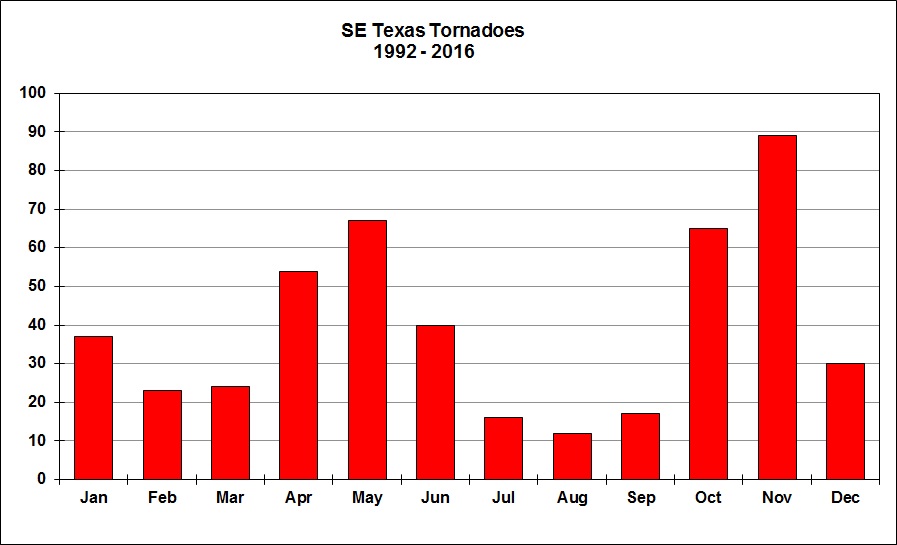
The tornado chart shows more occur in November; The worst experience I’ve had with one was in Nov. Channelview was hit hard; fortunately many people weren’t home-out shopping for Christmas. 1 of my employee’s home was destroyed.
A little humor !!! It looks like every spring, week after week, the weather– Monday- Thursday is great, but every Friday – Sunday we have storms !! Why don’t we skip over a Tuesday- Thursday period just one time ! ‘ You know, just go from Monday to Friday one week ! Then all the good weather will be on the weekends , and all the storms will be in the middle of the work week !!!!
I was quite surprised to see November as the most active tornado month…oooh joy…I now get to worry more about November…
I can’t say for sure (I don’t know where to find the proper climatological data) but I have a hunch that many of November’s tornadoes are from tropical cyclones. Tropical systems can spawn many tornadoes; however, it is very rare for tropical cyclones to spawn significant (EF2+, or peak winds exceeding 111 mph).
If the chart were to only include significant tornadoes, I think that the autumn months would be less impressive.
November’s storms are related to strong cold front passages, generally. Houston does not receive tropical weather in October or November, typically.
Ah, that’s true. Shows how much I still have to learn, I suppose. By the way, if it isn’t too much trouble, where exactly did you find the bar graph of SE Texas tornadoes? I poked around the NWS page for our CWA and the SPC, but I couldn’t find anything like it. (Though I will say that the SPC’s severe weather heat maps are very nice.)
Hi Milt! I wouldn’t worry too much about tornadoes down here. Sure, they’re possible, but the probability that they directly affect you is quite low.