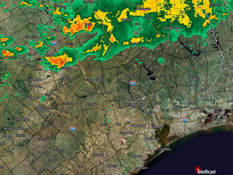
Good morning. As expected, fairly strong storms have developed well north of Houston during the overnight hours, generally from Temple to Lufkin. The primary question for today is how far those storms sag southward.
Today
A convective system has formed along a dying cold front, which should make some general southeastward motion this morning. Several high-resolution forecast models (which are frequently run, and cover a smaller geographic area than global models such as the GFS) indicate that a cluster of these storms will break off move toward Houston later this morning, and into the early afternoon. If this happens, it would bring some heavy rain—perhaps 1 to 2 inches—and gusty winds. With that said, there’s not too much support for this idea on the radar, at least not yet, and I’m pretty skeptical. Needless to say, the forecast is pretty uncertain, with storms possible, but far from a lock.
Regardless, high temperatures should reach about 80 degrees under mostly cloudy skies, and the threat of rain and storms should end this afternoon or evening. Overnight lows will fall into the mid-60s.
(Space City Weather is sponsored this month by The Mole, a Jonathon Price novel.)
Wednesday and Thursday
As some high pressure builds into the area, expect quiet weather for the mid-week period, with highs of around 80 degrees, and overnight lows in the mid-60s. We can’t rule out a few very scattered showers, but for the most part the region will stay dry.
Easter weekend
Conditions will be much the same through the weekend. Highs will probably nudge up into the low 80s, and overnight lows into the upper 60s (and 70s along the coast). This isn’t going to be splendid weather for a holiday weekend, I fear it’s going to be too muggy for that, with some breezy winds moving in from the Gulf. But on the positive side, we’re unlikely to see any storms, and any rain showers that develop from Friday through Sunday should be scattered, and short-lived.
Next week
Some slightly better rain chances return next week, but don’t look for any moderation of temperatures. Highs in the low 80s, and warm nights will remain par for the course. Some of the global models are hinting at the possibility of a cool front late next week, but I would not bet on such a thing at this point.
Posted at 6:55am CT on Tuesday by Eric
Eric –
Many of the hi-res models are showing less of a “sag” and more of what I would say is new development along a line from roughly from Sugar Land to Corpus Christi starting around 2:00 this afternoon. Basically, the line of storms is weak as it passes through the Houston Metro and then fires up again on the other side towards the southwest. Is this what you are saying isn’t supported by the radar this morning?
I gotta say, I went to bed expecting storms when I woke up and the forecast has pretty much been a dud so far. Everything moved left to right horizontally instead of diagonally.
What I’m saying is that the radar this morning was not consistent with what the high resolution models were forecasting for that time, which led to very low confidence in their output for later today.
Stay north, rain! I’ve got roofers deconstructing the top of my house and I want to get it done soon!
Looking at the radar at 9:00 it really does seem that the models are all too far south. The cluster of storms that was predicted around San Antonio appears to actually be north of Austin and instead of moving southeast everything appears to be moving due east. Am I missing something?
Eric — your Easter weekend update is giving me life. My wedding is this Saturday, so I’d really like you to keep up with those positive-thinking “unlikely to see any storms” language as much as possible. <3 <3 <3 – From a weather-anxious bride-to-be