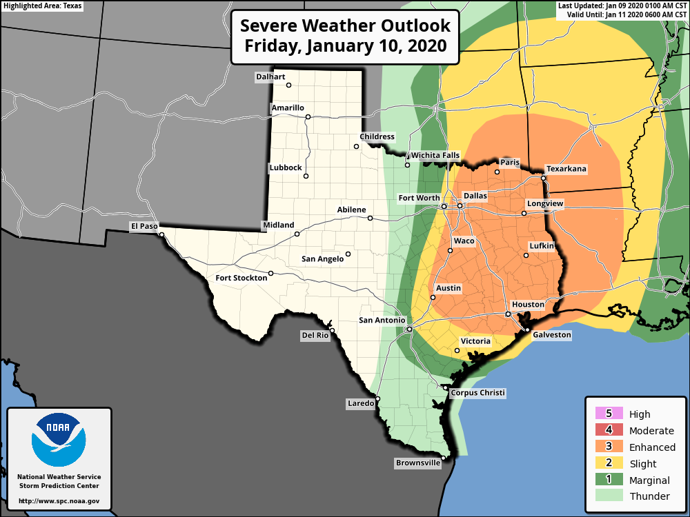
We’ll say goodbye to sunshine for a couple of days, and our focus will now turn to the potential for severe weather on Friday night. A strong line of storms will sweep through Houston from west to east, likely from about 9pm to 3am. All of the usual threats will be there—large hail, damaging winds, and potentially tornadoes. Because of the storm’s progressive movement, we do not expect rain totals much above 0.5 to 1.5 for widespread areas, with higher isolated amounts. It may be severe, but it will be over quickly.
Thursday
Today will be mostly cloudy, with southerly winds continuing to pile moisture into the region. However, a fairly stiff capping inversion—this is situation where warmer temperatures higher up in the atmosphere prevent warm, moist air at the surface from rising—should preclude all but some scattered, light showers today. Highs will reach the upper 70s for most of the area, and temperatures Thursday night will not fall much below 70.
Friday
Friday will start out a lot like Thursday, with an increasing chance of storms throughout the afternoon and evening hours. While you may see some showers during the daytime hours (which will be warm, with highs again likely in the upper 70s), the main event will be a line of storms moving through. NOAA’s Storm Prediction Center has expanded the area of “enhanced” weather somewhat southward and westward. This means it will be possible, but by no means certain that we will see strong wind gusts of 75+ mph, large hail and tornadoes. There will be heavy rainfall too, but it should move through quickly. The bottom line is that if you are out and about on Friday night, be very weather aware. (I’d definitely plan to be home before the storms hit). And if you’re at home, be prepared if a tornado warning is issued for your area.

Saturday
As quickly as it boils up, Friday night’s severe weather will exit the region before sunrise on Saturday. This will lead to clearing skies and pleasant weather, with high temperatures near 60 degrees. Lows Saturday night will be chilly, perhaps around 40 in Houston, and in the 30s in outlying areas.
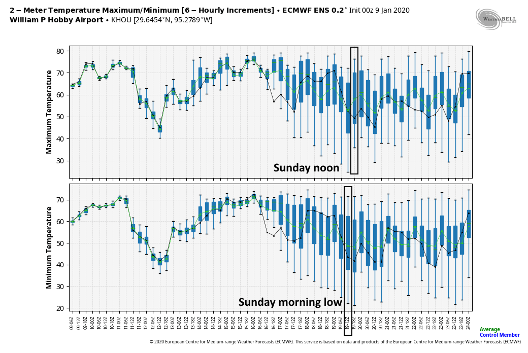
Sunday
The second half of the weekend will also bring ample sunshine, and highs in the low 60s. However, a returning flow of moisture from the Gulf will return to warm us up by Sunday night and Monday.
Next week
This return flow from the Gulf of Mexico will set the stage for warm and potentially wet weather through the middle of the week. We have no expectations for storms, but rain chances will be on the order of 40 percent or so each day beginning Monday, with cloudy skies. Daytime highs will push into the 70s, with warm nights in the 60s likely.
Houston Marathon
So what does this mean for the end of next week? We are now 10 days out from the Houston Marathon so we can begin to have some slight confidence in the forecast. Alas there is not too much clarity beyond the warm midweek. The GFS model and its ensembles lean toward a Thursday-ish cold front, while the European ensembles are generally more delayed, leaving it to Friday or Saturday. The former solution, the GFS, would mean that Houston is beginning to warm up by Saturday, with a morning low in the 50s or low 60s. The European solution suggests potentially cooler weather, with lows in the 40s. Right now, if I had to guess, I’d pinpoint the race time temperature at 50 degrees. But I would not feel great about that forecast—at all.
What the heck is going on with this January? Maybe my brain is off a bit, but it feels like this has been a crazy warm month and it looks like it’s gonna stay crazy warm. It’s only a dozen or so weeks before we’re back to summer hell, and this muggy upper 70s stuff is wasting the small amount of precious cool weather time that we get down here 🙁
Thank you wonderful Eric for sharing the weather news to keep us safe. I wish all safety Friday and hope the rains and storms are not horrible. It will certainly be a stressful night for me as I comfort my dear Fulgencio but the wonderful Houston will be a wonderful weekend! Blessings to everyone!!
#EvacuateFulgencio
Amazing. Should Fulgencio evacuate?
I think this is the first “enhanced” we have had here in several years, not counting hurricanes or course.. Correct me if I am wrong….
Eric, when you say that this will move in between 9 pm and 3 am, and that it will move quickly, does that mean it could move through Houston as early as 9 pm and be over with around 10 pm? Or should we expect ugly weather off and on between that 6 hour timeframe?
My experience is it will be like your first example. Rain and hard wind rumbling through like a freight train. Likely 90 minutes of bad weather or less. Once it passes, should be amazing weather on the other side.
Need professional advice here: the standard for a tornado warning is to go to an interior room on the first floor. I don’t have any such thing. My “first floor” is a garage and my second floor doesn’t have interior rooms, all have an outside wall, except one hallway (but that’s not a room). What should I do if a warning is issued?
Run away… Run away…
A 1st floor bathroom is good, if possible crouch in the tub.
The idea is that you have as many walls or barriers between you and the projectiles fired by the tornado.
A first floor bathroom is good. Crouch in the tub of possible. The idea is to put as many walls between you and tornado debris.
I would think the hallways with all doors closed would be your best bet.
Since it’s multistory, getting inside your car inside your garage would offer solid shelter. The second floor hallway would also be good so long as you have a 3rd floor above you.
I have an attic above me. That’s it. and not a big one.
I’m from Chicago where a tornado ‘warning’ meant there was an actual tornado sighted and/or confirmed on the ground or headed that way. Things have changed since we moved south where a ‘warning’ sometimes means radar indicates rotating storm cells – regardless of whether they’ve sighted an actual funnel cloud/tornado and whether it’s confirmed or not. I get the public safety angle especially at night, but in the Midwest you’d never leave your house/basement (yes we have those there!) if you went by radar only rotation. I’d say heading to your bathroom with heavy, soft blankets/clothes over you in the tub is a good bet (regardless of a window) as most bath tubs are pretty substantial and will surround you if something blows your roof/walls out. One thing I would NEVER do is stay in a car and/or try to outrun a real tornado! So many deaths are from people who were killed when their vehicle was flung like a toy and crushed. A strong wind can push over a loaded freight train so no car or truck – even in Texas – is ever going to protect you.
Since the invention of doppler radar, the NWS in Chicago issues Tornado Warnings the same way as the NWS in Houston. They may be either radar indicated or spotter/law enforcement confirmed, but either way a tornado warning is issued.
Arianda, I’m by no means a professional but your hallway sounds like the best spot to hunker down in case of a tornado.
SPC has been pretty persistent for Severe Storm potential since Sunday and not moving the 15% bubble much at all. Guess we will see a dead ringer for a decent chance at least. I’ve got a decent HRRR and NAM resolution but it’s by no means top notch. Wondering if you guys could send out a run or two today since you probably have better res.
The long term forecast on Wunderground and weather.com shows chance of rain and complete cloud cover for like 2 weeks after this weekend.
Is this really going to be realistic, that we won’t see the sun anymore for 2 weeks after this weekend?
Definitely no expert but two weeks out are only covered by Euro and GFS. While this long range guidance is quite accurate as they have come a long way since the beginning…a two week stretch is pretty far out to show much accuracy. TWC also likes to try to guess at long range. Basically everyone is rolling the weather dice with a long range forecast. Ten days is a little more in the ballpark and one week is better still. Obviously…things can still change in the drop of a hat even 24 to 36 hours out. Glad we have Eric and Matt for sure.
I believe TWC bought Wunderground a few years ago. You might be reading an echo chamber. And Monty’s comments are spot on
good point about the echo chamber. i just checked the long term for accu weather and that one doesn’t look as dreary …
I have visitors come into town and I told them how nice our January’s are. I hope the weather won’t make a liar out of me 😉
https://www.accuweather.com/en/us/houston/77002/january-weather/351197
You run TOWARDS a gun & AWAY from a knife…
I am so confused by this comment.
Have you also noticed that with this awful, mild winter that grass has not even gone BROWN?? It is mostly early spring green. Even in Dallas too as I saw this past weekend. Bugs and ants in particular are gonna be INSANE this summer, folks…
is there any chance for ice/snow for next weekend? it keeps changing from model to model but some say maybe and some say a hard no, but except for 1-2 fluke warm models it has showed the coldest temps for overnight Thursday though Saturday on almost every run but some also show moisture and some don’t, what is your stance on this?
Eric and Matt, if you are reading this, please help quell the “noise” about this event. Newspapers, news stations, internet, the weather channel, etc… I know you are the “no hype” go to, which is great, but is this really as severe as it sounds? Weather Channel puts us at a TOR:CON 6 (which i had to look up) and they are really hyping it because of the “overnight” aspect. I, for one, would like your “just the facts” and “bottom line” advice on this. Bring us all down to earth with the reality.
And, if you feel like it, I would be interested in knowing how often this happens here.
Thank you
My favorite Weathermen! I’m sure you’ll update again soon, but flying into Houston tomorrow at 3:45pm. Keep seeing crazy things on the severity to expect. Should I be trying to adjust to make it home?
Thanks as always for y’all’s great work!
I’ve been training for a BQ/PB at the marathon, so here’s hoping the Euro model is correct and solidifies into a low 40s start time. And no wind would be nice. Eric, can you make that happen please?
All the talk about the models reminded me of an outstanding book I read this year. “The Weather Machine,” by Andrew Blum. Full history of weather forecasting and the development of the weather models. Very well written, and readable by the average layperson. I can’t recommend it highly enough if you are interested in those things. https://www.amazon.com/Weather-Machine-How-Into-Future-ebook/dp/B01N17CYXK
And no, I’m not affiliated with the book or author or any way. Just thought other people interested in weather would enjoy it.
Uh, clicked link, not available for purchase.