It is quite cold across Houston this morning, with temperatures generally in the 30s in outlying areas, and low 40s in the central Houston area. After days and days of sunny weather our skies should turn cloudy later today, warmer, and then stormy on Friday, before pleasant weather returns again for the weekend.
Wednesday
Just a quick note: With clear skies on Tuesday and Wednesday mornings, please note that if you saw a white streak in the sky above Houston during the pre-dawn hours, it was this the of 60 Starlink satellites launched Monday night by a SpaceX Falcon 9 rocket. (More information on how to see them here). They will gradually become fainter as they raise their orbits over the next month.
Overall, today should be another nice one, with partly sunny skies and temperatures in the upper 60s. However, winds will become noticeable out of the south later this afternoon, gusting up to 20mph, bringing much more humid air into the region, and setting the stage for storms later this week. Lows Wednesday night will be considerably warmer, unlikely to fall below 60 degrees in Houston.
Thursday
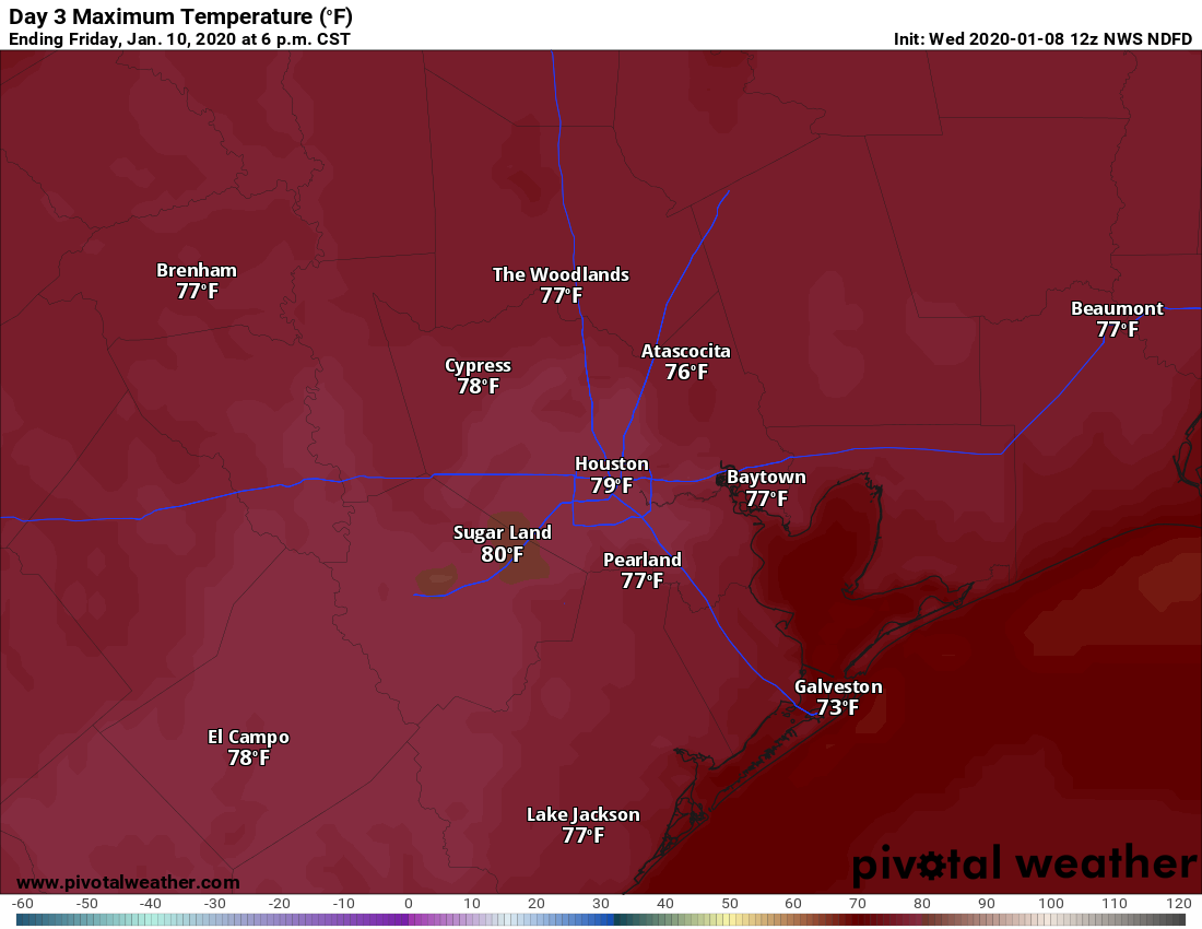
A gray day. Expect highs to rise into the mid- to upper-70s despite the cloudy skies, More gusty winds from the south will continue to transport moisture inland, and we can’t rule out some scattered showers and thunderstorms during the afternoon and evening hours—but we don’t expect significant accumulations. Thursday night should be rather warm, likely in the upper 60s.

Friday
Conditions will align on Friday to produce a very healthy chance of storms, although they are unlikely to develop until the evening or overnight hours. The daytime conditions should be a lot like Thursday—warm and humid, with some scattered showers and thunderstorms. For now we anticipate a capping inversion holding down daytime storm chances. The bigger threat will likely come during the time frame of 9pm to 3am for the Houston metro area as a line of significant thunderstorms moves through.
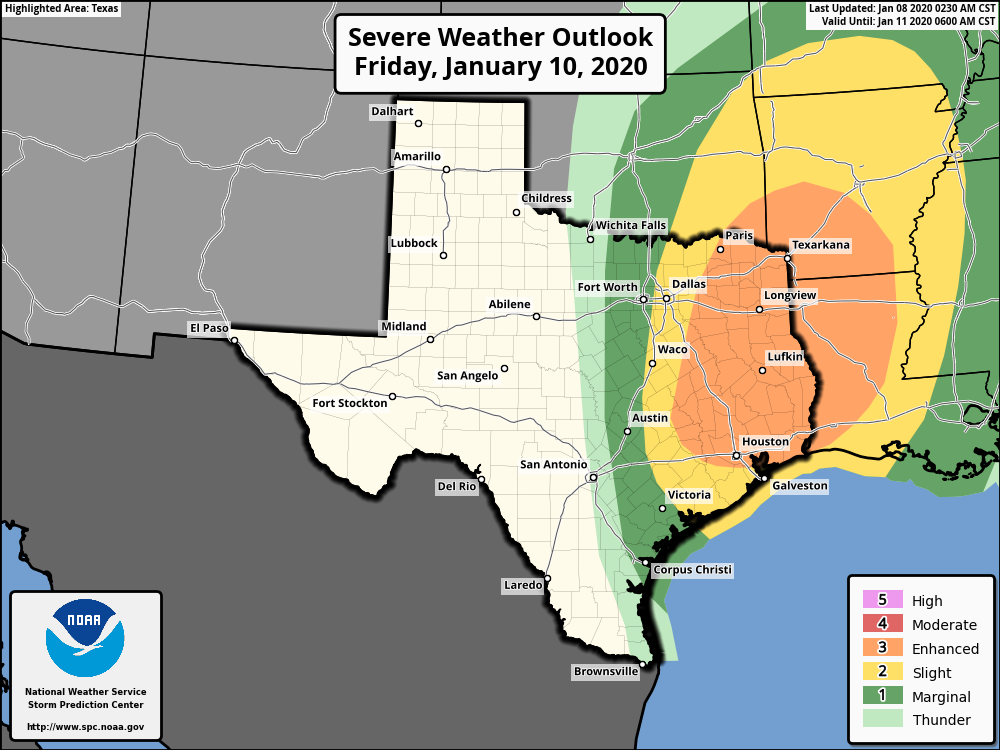
NOAA’s Storm Prediction Center has the northern half of Houston under an “enhanced” threat, and the southern part under a “slight” risk. The bottom line is that some time on Friday night you will face the risk of damaging winds, hail, and possibly tornadoes as the front blows through. Rain accumulations should be 0.5 to 1.5 inch for most of the area, with higher amounts possible.
Saturday and Sunday
Houston’s weather in the wake of the front still looks splendid, with sunny and cool conditions for the weekend. Look for highs in the low- to mid-60s and a cool morning Sunday in the low 40s for Houston, and upper 30s for northern areas. A chance of rain will return fairly quickly, by Sunday night or Monday morning, although we don’t anticipate more storms like those on Friday night.
Houston Marathon
Has the forecast for Sunday, January 19 come into any better focus? Sort of. We still expect some kind of cold front around Thursday, January 16th. But our questions on timing and strength remain, with a couple of scenarios in play. First of all, the front could be fairly strong, or even followed by a reinforcing front, which keeps conditions cold for race day—perhaps around 40 degrees. Another possibility is a weaker front, which means that by Sunday morning our weather will be on the upswing, with lows in the upper 50s.
What I’m seeing less risk of is a really warm race day. For example, later this week, on Friday morning, we’re going to see lows in the upper 60s in downtown Houston. The same thing will likely occur next Tuesday and Wednesday in the city. While we cannot rule this out for the marathon, I’d say there is an 80 or percent chance of start-line temperatures below 60 degrees.
I have seen rumors of a possible winter storm next weekend. Is that true?
Kyle Where did you hear that from??? Darrell
Is this Friday/Saturday weather event common? You don’t make it sound like a big deal – just the usual – hey there’s going to be severe weather, but NHS is making sound really, really scary……….
Can someone who has lived here a long time answer?
I have been here 12 years and my experience has been to always listen to the warnings from the NWS and heed them. The storms in Houston can often produce high winds as gust-fronts along with lots of rain and lightning. Just be sure to shelter indoors and have supplies ready for a power-outage. Tornados are rare but can happen so make sure you keep track on a good weather app and local TV. The usual experience is lots of noise and a REAL good soaking. But listen to the warnings – they really know their stuff here.
for what its worth, the storm chasing community appears to be zeroing in on dfw and points north and east. We may get a tornado warning or two friday night, but seems unlikely to be the big, dangerous, discrete storm variety.
SPC has a dismal record at our neck of the woods on the Enhanced Risk forecast. I’m sure I no more say this than I’ll be proven wrong so the guard will be up.
Oh no I hope we do not have the storms on Friday night the ones that come in the darkness always frighten my dear Fulgencio so much!! Blessings and happiness to all!
Dear Fulgencio will survive
We sure do need the rain out here in Katy, TX but this storm sounds serious. Enjoying the warmer temps but prepared to evacuate!
keeping my eye on your marathon forecast and crossing my fingers for the coolest scenario possible!
Driving to Dallas from Houston on Friday. I plan to leave early in the day but am I heading into a bad situation? Are the storms coming from Dallas to houston?