Before we get into the heat, we still have a couple things to discuss, including the potential for a few stronger storms today. We’ll hit on that, but then we’ll assess the upcoming heat, how long it may last, and how hot it may actually get.
Today
For all intents and purposes, today may be like the last couple days have been in Houston: Hazy, sunny, then afternoon pop up storms. The haze is primarily a result of agricultural burning in Central America and southern Mexico. It does appear that air quality readings are a bit better this morning than they have been this week. Ground ozone will again be an issue today due to sunshine, warm weather, and light winds.
Today’s forecast is a bit more difficult than normal for this time of year. We have a lot of “juice” for thunderstorms, including healthy instability, a little bit of wind shear, and a lot of chaotic boundaries that may interact with one another this afternoon and evening.
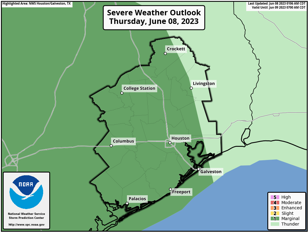
We will probably see storms begin to pop up after 12 to 2 PM as they have on most afternoons this week. From there, it’s very difficult to predict the exact evolution of things. Storms may interact with each other, in addition to old boundaries sitting over the area. We may also add in a cluster of new storms coming in from the north and west as well. Whatever the case, it would appear that some of us will be in for some stormy weather late this afternoon and early this evening. Have your umbrella and a place to sneak indoors available. If you have any late afternoon outdoor activities, have a way to get warnings and move inside if you hear thunder We saw numerous lightning strikes seemingly out of the blue yesterday afternoon near my house before storms had actually developed.
Aside from storms, look for highs generally in the low-90s today.
Friday
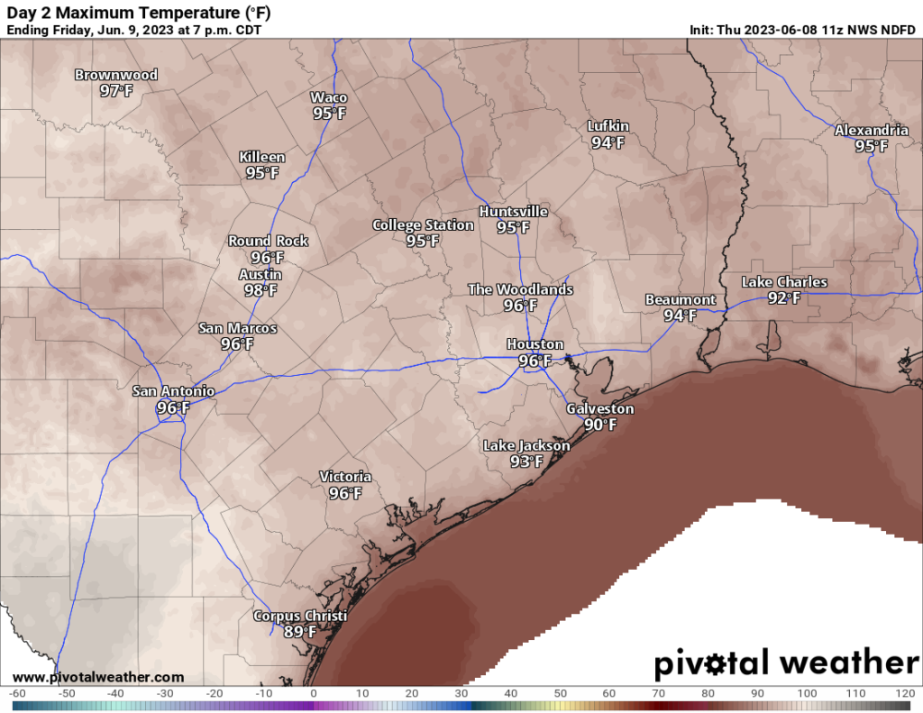
We will begin to see high pressure in the upper atmosphere build out of Mexico and into Texas tomorrow. This will allow for most places away from the coast to touch the mid-90s or even a bit hotter. Morning lows will be generally in the 70s.
Rain chances will again be in the forecast, lower than today but not near zero. Some isolated stronger storms may again be possible, especially east of Houston toward Beaumont and Port Arthur.
Saturday
We interrupt this developing heat wave with a quick interlude. A weak disturbance will disrupt the burgeoning ridge of high pressure over Texas and probably increase rain chances a bit on Saturday afternoon or evening, especially north of I-10. Most places will probably stay dry, but there will be some areas that see downpours. We should still manage to get into the 90s on Saturday, after morning lows in the mid-70s.
Sunday through Tuesday
Hot and humid. Rain chances won’t quite be zero, but they’ll be exceedingly low. High temperatures on these days will be well into the 90s with morning lows in the mid to upper-70s, if not near 80 degrees in spots.
When we start talking upper 90s by day and near 80 by night, that’s when you can start running into heat stress issues. Please make sure elderly, young children, and vulnerable populations (and pets!) are tended to next week. Also, you too! Our bodies have experienced a pretty pleasant late May and June by Houston standards. We have not acclimated to true summer heat yet. This will hit us pretty good. Drink water, wear sunscreen, and take it easy outside.
How long does this last?
If you look at upper level maps, it appears we might have a brief chance at better rain chances and slightly cooler temperatures Wednesday and Thursday of next week as a weak trough flattens the ridge some. But it is expected to then reload heading toward next weekend, so it will be awhile we think.
How hot can it get?
I guess the better question is: Can we do 100 degrees? The answer is yes. The National Blend of Models has us at about a 65 percent chance of hitting 100 degrees next Thursday, Friday, or Saturday. But that’s not guaranteed. Things that could wreck that chance include soil moisture, more numerous afternoon storms than expected, and high clouds from an El Niño-driven stronger than normal southern jet stream.
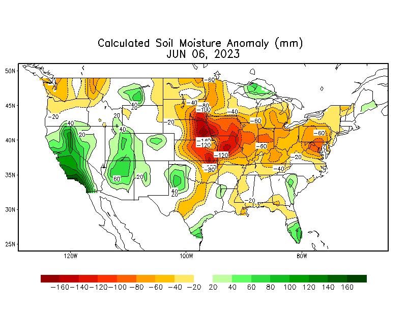
Soil moisture is running near normal or even slightly above normal in our area. A drier ground heats up more efficiently, but more moisture in the ground can slow down that heating process a bit. Thus, this could be good for knocking a degree or so off temperatures next week. So maybe instead of 101°, we end up near 99-100° or so.
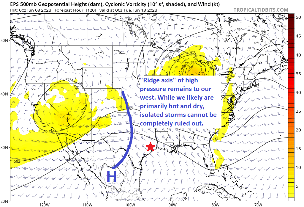
The axis of high pressure for much of next week is centered over and just west of Hill Country. While Houston isn’t exactly on the periphery of that, there is always the chance that models are underdoing our rain chances some. Higher rain chances may yield slightly lower temperatures.
Lastly, the jet stream has been humming over Texas and Mexico lately. This is likely tied back to the developing El Niño in the Pacific. Anytime you have an active Pacific jet like this, you run the risk of high clouds. Should we get more of those than expected, look for a couple degrees knocked off high temps next week, but perhaps a degree or two added to nighttime lows. This would be true more so early on than later next week.
With all that said, I think there’s probably a better than 50 to 60 percent chance we hit 100 degrees next week, with multiple 98-99 degree days peppered in between. Either way, hot. Very hot.


Given the upcoming heat, what are your partners at Reliant (and other local suppliers) saying about their ability to handle the increased load on their systems?
That is always up to the power generators. Reliant (and all of the other REPs) are just the go-betweens that happily take our $$.
Thanks for this useful forecast, Matt! I’ve never been a fan of rain in our local area (since it just keeps it humid) but I am rooting for widespread persistent cloud cover since it does block the solar rays.
Even if it only knocks off a degree or two, it is worth it.
Actually, the large sauna sitting off the coast is the primary culprit responsible for our humidity. As alluded to above, the rain-soaked soils, aside from helping maintain vegetation and keeping our foundations from slumping, also help to moderate air temps, if ever so slightly. I’ll never eschew rain here for, as we all know, it can be dry as a bone for weeks on end at any time.
Noooooo. I’m not ready to have my morning run be in the 80s.
Time to load up on Skratch Hydration!
Since you felt you should mention a brand, NUUN is just as good as Scratch and lot cheaper.
💕💕LOVE YOUR INFORMATIVE POSTS💕💕
So grateful for them!
Tysm 🌬💕🌀🌻🌀💕
el nino has begun
They keep promising the heat will come, but it’s just more and more rain, as well as vicious lightning. I saw a lightning bolt that kept re lighting about four times, and, like the post said, the lightning might come before it rains, or after the rain, without warning. The lightning is blamed for causing a fire that destroyed the oldest house in Dickinson.