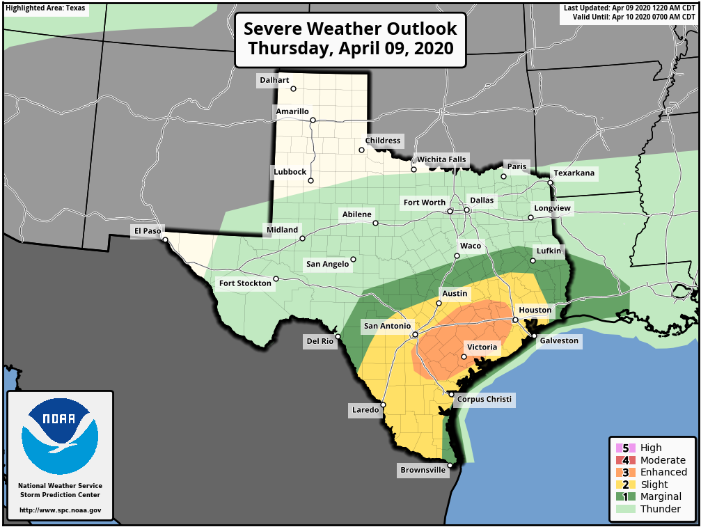
Good morning. Confidence is increasing in the potential for severe weather this afternoon and evening in Houston. The primary threats from this will be strong thunderstorms, and the potential for large hail and downbursts. The chances for hail and damaging winds are better for the western half of the metro area.
Thursday
Skies are mostly cloudy this morning, with temperatures in the 70s. Clouds will remain as highs work their way into the upper 80s this afternoon. Storms are likely to get organized off to the west and north of Houston late this afternoon, and shift into the metro area from about 5pm to 10pm tonight. While most of the region probably will get around 1 inch of rain, or less, these storms have the potential to pretty quickly drop 3 or more inches in some locations. Therefore it is possible we will see some brief street flooding later this evening. The front should exit off the coast, along with the heavier rainfall, by or before midnight.
Friday
A few light showers may be possible Friday morning before sunrise, but for the most part we can probably expect mostly cloudy skies transitioning to some sunshine during the afternoon hours. With forecast highs in the mid-70s and lower humidity, this could turn into a fairly nice spring-like day. Which is good, because Saturday probably won’t be so nice.

Saturday
Rainfall on Saturday will be driven by an upper-level low pressure system and the eventual passage of another cold front. This precipitation will likely be less “stormy” than conditions Thursday, with less potential for very heavy rainfall. Even so, expect parts of Saturday and Saturday night to see widespread showers, with daytime highs in the upper 70s, and lows Saturday night not cooling down much.
Easter Sunday
This day’s weather will depend upon the timing of a cold front moving in behind Saturday’s rains. The GFS model says fairly early in the morning, the European model says shortly before noon, and other models have other times. The fact remains that conditions will likely stay cloudy with a chance of rain until the front passes, after which skies should clear and breezy winds will pick up out of the west. Right now our forecast for Sunday is a bit like one of those Easter eggs that you dye one-half in blue coloring, and the other half in red. The first part of the day before the front will be one way, and the other part the other way. Sadly, we can’t pinpoint down the timing of the front yet. I know that’s about as helpful as when I dropped my older brother’s beautiful blue egg he’d just made into the yellow coloring cup. “Accidentally,” of course.

Next week
After the front passes we can expect some sweet, spring-like weather for at least the first half of next week, with highs probably in the 70s, and lows in the 50s.
Is there a threat for tornadoes this afternoon/evening? That’s my biggest fear anytime I hear “severe weather”. I’m on the southwest side of Houston.
I’ve never liked the order of the adjectives in those NOAA severe weather charts you use.
To me, “enhanced” seems like a more serious thread than “moderate,” and why would “moderate” be the second highest threat level?
I know you didn’t pick them, but I’m curious if there’s some reason why they named them less intuitively than I would have.
That is a good point! I’ve never paid attention to the words and always just looked at the colors. LOL! Purple = very very bad, red = bad, orange = heavy, yellow and green = normal and light. Hahaha!
Any chance of hail today?
If you will look at the third sentence in the first paragraph you will see the words large hail. That should be a clue as to the chance of hail for today.
We are all under a lot of stress right now. Don’t be that guy.
Your “accidental” Easter story made me laugh this morning – thank you for that! Thanks for all your hard work and for keeping us informed calmly!
Missed the “accidental” egg drop!!! Hilarious!!! I need to read y’alls posts more carefully! There’s frequently some humor sprinkled in there!
Thanks for keeping us “weather safe” guys! #SCWROCKS
The timing of Sunday’s front is obviously problematic. I read that the GFS model has a greater level of uncertainty currently, due to the lack of aircraft data provided through the AMDAR system. Do you notice this effect in your ability to forecast?
Just looked at some CAPE values. GFS slapped over 4000 j/Kg this afternoon for our area. Could be a wicked afternoon. Stay safe everyone.
Threads always deteriorate after a couple posts. Someone always feels the need to be smarter than the previous comment. Try to keep your comments positive (if your intelligence level allows).
Easter is cancelled.
See how hard it is to remain positive…lol
No matter how Easter shakes out, I’m just glad we’re getting back to “normal” spring weather temps. We’ll have plenty of time for the usual hot and muggy summer Houston weather.
On the future radar on Weatherbug, it looks like the storms are stalling out around the Beltway 8 (North Belt) and just unable to form south of there. Any reason for this? I kinda wanted the rain.
Never mind (maybe). Just got cloudy and windy in Bellaire.
So, the did the models get majorly fooled? Didn’t really seem like this amounted to anything.
Guidance in general looked to have faired fairly well. I know what you mean though. While the general direction looked to be ESE the stronger cells decided to carve separate paths. Supercells seem to have a mind of their own. What looked to hit us with certainty ended up heading more to the East. We got a half inch of rain and no lightning strikes within range to hear a thunderclap. I’m guessing SPC errs on the side of caution when hoisting risks. For all intensive purposes…we should have had a lot more action…especially when we were in the Significant shade for this afternoon.
Intents and purposes….