The Arctic front has pushed all the way off the coast and temperatures this morning are in the 30s and 40s. Welcome to your new reality, Houston. It’s possible the region won’t see temperatures in the 60s again for a week to 10 days, and there will be plenty of freezing weather in between. Our biggest concerns remain focused on next Monday—when roads could turn icy across much of the region—and Tuesday morning when lows could drop into the teens.
Thursday
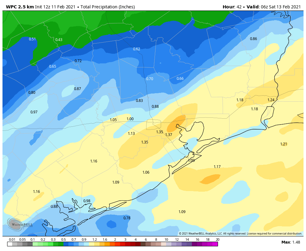
Today will be rather grim, in terms of weather, with widespread showers and highs only reaching into the mid-40s. Most areas will likely see on the order of 0.5 to 1.0 inch of rain or so today and tonight, with higher amounts definitely possible underneath heavier showers. Lows tonight will get into the upper 30s, but stay above freezing and therefore keep roadways wet rather than slick in the metro area.
Friday
I think we’ll continue to see the potential for light rain on Friday, although the showers will not be as widespread as on Thursday. When it’s not raining, skies will be gray, and temperatures should again peak in the low 40s.
Saturday
The region should see a break in precipitation from Friday night into Saturday. Perhaps we’ll even get a peek at the Sun? Anyway, it won’t matter much as highs should remain confined to the mid- to upper 40s. Some slight rain chances may return later in the day or during the evening as an upper-level system approaches from the west. For now, low temperatures Saturday night will probably remain just above freezing in most of Houston, but inland areas may well see their first (of several) freezes during the coming stretch.
Sunday
Sunday will be another cold, gray day for the region. The models seem a little more bullish on some light rain falling, so lets call it 30 percent during the daytime. (It’s possible that some areas north of Conroe may see this falling as snow or freezing rain). Highs will be in the 40s, and as additional cold air starts moving into the region temperatures on Sunday night should drop into the 20s—mid- to upper-20s, maybe?—in the city of Houston, with colder conditions inland. The immediate coast may still avoid a freeze. We’ll see.
Monday
The outlook for Monday, which surely will change further so please bear that in mind, now looks to bring widespread, mostly light precipitation into the region from around sunrise to sunset. Because temperatures will be in the vicinity of freezing for much of the day, this raises the important question of whether this falls as cold rain, freezing rain, sleet, snow, or all of the above. At this point I’m reasonably confident that areas north of Interstate 10 will be cold enough on Monday, during the day time, to see some sort of wintry precipitation. I think the jury is still out on areas closer to the coast. But again, this day has the potential to be a real mess for traveling through the region, so be preparing for that possibility now.
Tuesday
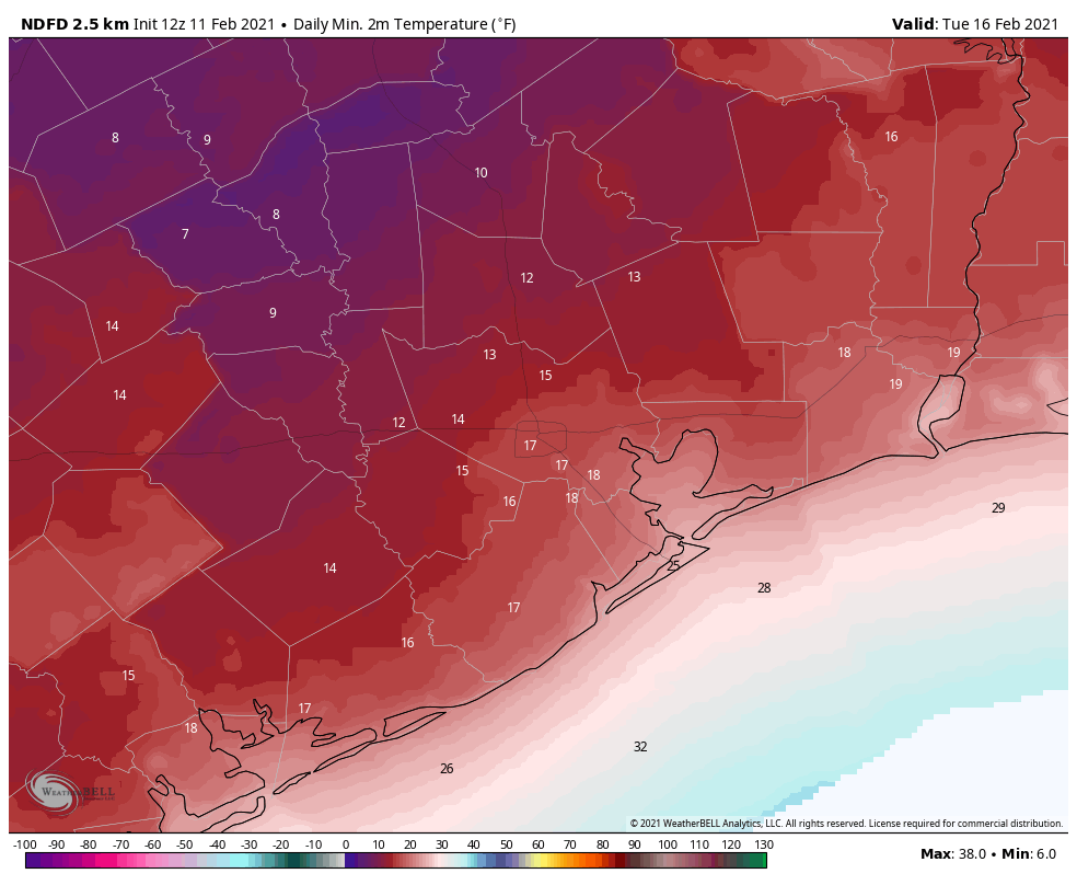
We now think the precipitation will end sometime on Monday evening, or so, and this may allow for some clearing skies overnight and into Tuesday morning. (Will this allow roads to dry by Tuesday morning? It’s difficult to say). Regardless, the absence of insulating clouds will create ideal conditions for cooling with this very cold air mass. The region is virtually certain to see a hard freeze on Monday night and Tuesday morning, with lows potentially from 10 to 25 degrees in the city of Houston. This will wreak havoc with exposed exterior pipes and vegetation, and animals must not be left unprotected in these kinds of conditions. Check on neighbors to make sure their heat is working. Sunshine should allow temperatures to recover into the mid- to upper-30s on Tuesday. Lows Tuesday night will again flirt with freezing levels.
Wednesday and beyond
Forecast models indicate yet another reinforcing front moving into Houston on next Thursday or so that may again lead to a widespread freeze and raises the potential for some more wintry precipitation. I have zero confidence in trying to forecast that period. By next weekend we should finally be headed back toward days in the 60s and nights in the 40s, and this will all behind us. Spring, after all, isn’t too far away. But it’s not coming today!
Matt and I will, of course, be with you for the duration of this event.

ONE thing in this post made me smile: the closing sentence “Matt and I will, of course, be with you for the duration of this event.” That brought on the warm fuzzies!
Amen to that!
Thank you!
When I first saw the email preview, I thought it said “and there will be plenty of pie” mmm mmm pie
Unfortunately, this is a pie-free forecast.
Icebox pie.
This forecast definitely needs more pie.
And more cowbell
More pie!!! We demand a forecast with pie in it!!!
Talking about pies has made me hungry for pie – so now I have to bake one!!! 🙂 LOL
Today will be rainy and chilly, yes. But “grim”? Isn’t grim when the bayous are threatening to overflow?
Hey guys. Thanks for the updates on this, it’s invaluable.
We have plans to stay in Dallas for the weekend and drive back Sunday down to Houston, in your opinion will I-45 be too hazardous with ice and snow to make it back? We don’t have winter tires because… we live in Houston.
Thanks !
It seems that quite a few vehicles ’round here are on “summer” tires – and yes, they don’t work well at subfreezing temps. Google “glass transition” (that’s the term tiremakers use) for what happens to “summer” tires below freezing.
Personal experience – they’re slick as owl snot…
Dallas is already a mess today. If you’re not there yet, you’re not likely to get there safely at this point. An ice storm is moving across central texas between here and there right now.
Thanks Eric for the update!
Nice to hear an honest no hype discussion, instead of the cold-pocalypse/ 50 year event/we’re all doomed coverage on the local stations
I agree!!
Better than hurricanes. Flooded twice. We can all get through this. Like the guys say. Prepare.
Stock up on the hot chocolate. This is vital.
You spelled coffee wrong!
Brrrr!!! Shivering just reading this forecast. Will it kill all the cockroaches? 🙂
Asking the important questions.
Nope. They’d make it through a nuclear holocaust.
Nothing kills the cockroaches. Lol.
Will it be windy or just cold?
Thanks!
FYI on Summer Tires (and I’ll bet lots of folks have ’em and don’t realize that):
https://www.tirerack.com/tires/tiretech/techpage.jsp?techid=273
Most cars have all season tires. The summer tires are made of softer rubber, which gets harder around freezing causing the tires to lose grip below 35 degrees. All season tires should be OK. The summer tires tend to be on high performance cars.
True, most vehicles do. I have noticed that a number of the “local” tire shops seem to have a number of summer tires (my guess is that they’re from owners replacing them w/all seasons), and being from the industry I tend to look at such things when walking thru parking lots and noticing ’em on any number of performance vehicles. Only takes a couple of muscle cars to clog up a freeway…
I leave the mustang at home and drive the old civic. No worries mate.
Thank you Eric and Matt for all you do. Is it OK to go swimming on Monday?
Only if you have the proper SPF. Have you made a decision on that yet?
No. I always base every decision in my life on Eric and Matt’s input because I can’t make a decision for myself. I’m still waiting on them to get back to me on what to fix for dinner tonight.
I was not expecting the thunder and lightning and such heavy rain so early today so I’ll be moving wet plants inside now, instead of dry. 😉 On the upside, it helps them going into the heat for several days.
Another freeze tip — YMMV, but it’s served us well — if you park outside in an exposed area, cover your hood with a blanket, and before you start the car for the first time, do a walk around your vehicle, look under it, and knock on the hood — animals will often take refuge during a freeze event wherever they can, which includes warm engine blocks and wheel wells.
Be safe, y’all!
Shout out to Heather for this excellent reminder about checking your car for animals before driving off! It’s hard to remember since we experience this weather so infrequently.
Much thunder and lightning early this morning. Maybe a few days for reading and baking and hot chocolate.
This might seem like a silly question, but what can be done to protect exterior pipes? I come from the northeast where houses are built to withstand regular freezes. I’ve read a bit about what to do but I’d feel better hearing recommendations from local folks.
Best thing is to let faucets drip, just a little bit, like a few drops per minute–both inside and outside. You can wrap outside exposed pipe but if it gets really cold that won’t do any good.
Agree about dripping pipes. If you wrap them, you can do it with towels/ rags and duct tape, or I think some places actually sell insulation like a hollow pool noodle for the purpose.
Dollar store pool noodles work great!
Wrap the elevated sprinkler connector from your water line. I’ve seen two neighbors have those freeze and break, creating gushers. And if your washing machine is against an outside wall, or in your garage, wrap its water line pipes, too.
Dripping the pipes and leaving sink cabinets open to keep the house heat circulating to them is good for the light freezes. But for the extended hard freezes we like to turn the water off to the house overnight and run all the water out of the pipes. Don’t forget those hose spigots on the outside too.
Thank you everyone – this is all great advice.
Yesterday morning, my local Lowe’s already had a front-and-center display showcasing foam pipe insulation and plant wraps. Hopefully they’re not sold out yet 🙂 Cut it to length, fit it around the pipe. You can zip-tie it into place if you’re feeling particular. As someone else said, a pool noodle will work in a pinch. Procedure is the same. If you are not sure that is sufficient, you can leave a faucet dripping through the night; moving water doesn’t freeze as easily.
Freezing rain in Austin right now. Not a good idea to drive up there today.
Thank you for your continuing accurate forecasts. I really appreciate it here in Liberty.
Stay Blessed, warm, dry, safe, and well!
Happy Valentine’s Weekend!
What about Galveston county?
You just said the coast!
Thank you, guys, for your expertise and integrity in keeping us informed without the hype. You are a breath of fresh air 😊