Bonafide winter has arrived in Texas, and we’re just getting started. This may be Texas’s most severe and damaging cold snap since the 1980s, and it’s going to come with a significant mess on Monday, so do read on.
Today
After yesterday’s fireworks via quite a few thunderstorms in the area, we expect today to be a bit quieter. There should still be some showers, and there may be some drizzle as well. But we aren’t expecting much more than a few hundredths to tenths of an inch of rain today, and some areas will stay completely dry. The best coverage of showers should be south and east of the city. With plenty of clouds, temperatures won’t go far today. Look for highs maybe getting to 40 degrees or so, low-40s if you’re lucky.
Note to those traveling north or west of Houston, as we get a lot of questions: There may be some patchy freezing drizzle well off to our north, especially this morning. So if you’re headed to Austin, Waco, or Dallas, be hyperaware of road conditions. Bookmark drivetexas.org for updates for the state and the Houston TranStar site for additional local conditions.
Saturday & Saturday night
Tomorrow will likely be a similar sort of day to today. Expect clouds, some showers, some light rain or drizzle, and cold temperatures struggling to get to 40 degrees or so. There could be a slightly more vigorous disturbance that pivots through very late in the day Saturday or Saturday night and brings more numerous showers. If that happens, there is the chance that areas north of I-10 get close to the freezing mark and freezing rain (ice) could become an issue.
This would likely be mainly focused on the nighttime hours. The Houston area should just see a cold rain, but if you have to make your way north of Houston for any reason after 6 PM Saturday, you will want to pay particularly close attention to any forecast updates this weekend. Lows bottom out in the low- to mid-30s.
Sunday
That Saturday night disturbance should exit stage right on Sunday morning, and the majority of Sunday looks dry but cloudy. Because of the generally drier conditions, we may be able to sneak into the low or even mid-40s on Sunday afternoon.
Sunday night through Monday afternoon
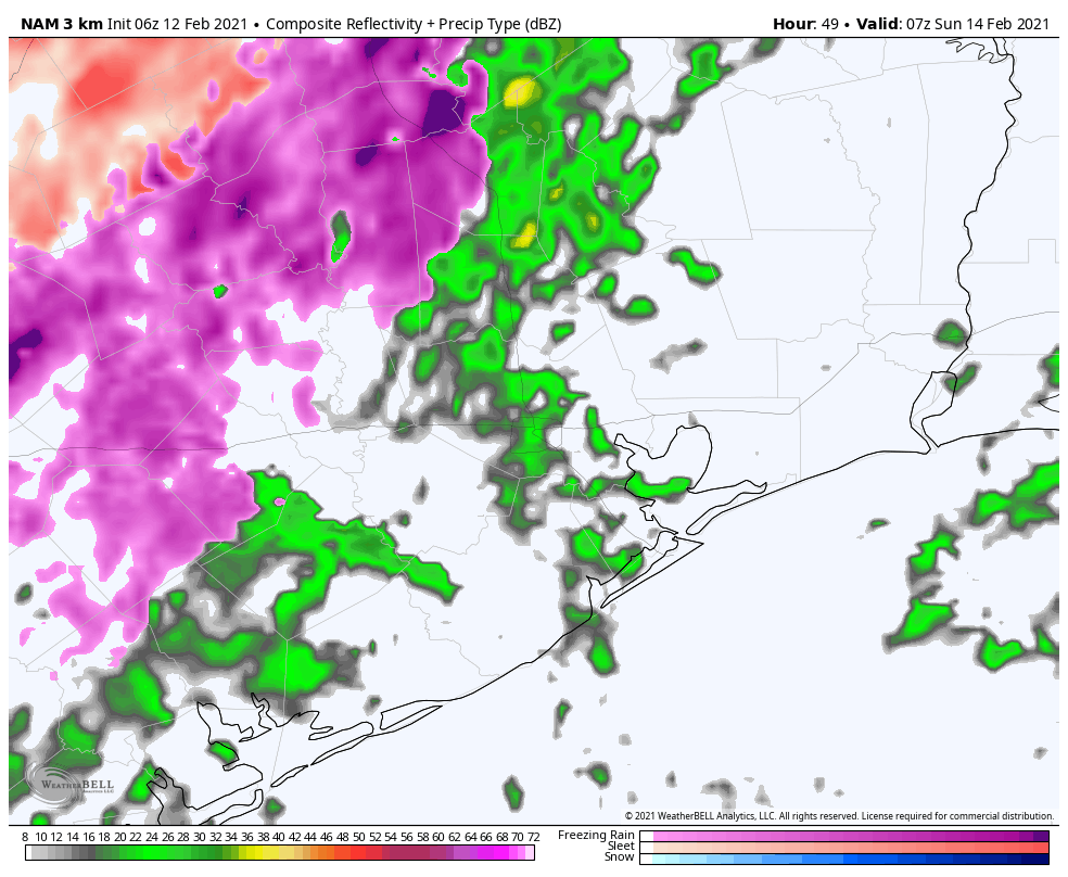
So, here’s where the troubling part of our forecast begins to emerge. As we’ve been discussing for days now, a strong disturbance and storm system are going to pass through the region on Monday morning. We are growing highly confident in wintry precipitation impacting almost the entire region, including the coast on Monday now. There is a good chance that travel may become close to impossible anywhere in the Houston area beginning early Monday morning.
Here’s what we know right now:
- Rain, or a wintry mix will develop on Sunday night.
- It will likely quickly transition to all freezing rain and/or sleet, except maybe at the immediate coast before sunrise Monday.
- Precip may be heavy at times Monday morning.
- Frozen precip will likely end as some sleet or snow flurries by early Monday afternoon.
- Ice and/or sleet accumulation is likely across much of the area.
- Temperatures will likely remain below freezing all day Monday, dropping into the lower 20s by afternoon.
- Winds will gust to 20-25 mph most of the day Monday.
Now, for what we really don’t know:
- Whether sleet or freezing rain will be the dominant precipitation type (snow seems mostly unlikely except well north and west of Houston or at the very end of the event).
- How much sleet and/or freezing rain falls.
- If there will be snow accumulation at the end.
- The exact timing of the storm. (still some 3+ hour differences among various weather models)
- How many power outages will occur.
Those first two points are very important, as there is a monumental difference in impacts between an all-sleet storm, an all-ice storm, and an ice storm followed by sleet. A couple inches of sleet is a nuisance, but it’s not severely problematic. A tenth to quarter-inch of ice with gusty winds and bitter cold could be extremely problematic. And a layer of ice caked over by sleet or wet snow is even more problematic. Unfortunately, we really aren’t good enough to predict winter storm precipitation totals to that specificity this far in advance. I can tell you that having looked at model data, they are loudly implying that a large portion of the area will be at risk for icing on Monday. This event will likely be problematic.
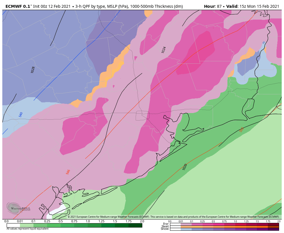
Much like flooding events, models struggle mightily when it comes to exact placement of the bullseye of a winter storm. But even putting that aside, any amount of ice on the roads here will make travel close to impossible, and that seems to be the direction we are heading for Monday.
So to summarize: A winter storm will impact the majority of the region late Sunday night through Monday afternoon with a sleet or ice storm being the most plausible outcome right now. We would strongly encourage folks to prepare to remain wherever you are from Sunday night through Tuesday morning. This forecast will change between now and then, and Eric and I plan to keep you posted all weekend long.
Monday night & Tuesday
The temperatures will be the big story once our storm exits Monday afternoon. We will likely see highs on Monday near freezing very early, dropping into the low-20s by afternoon. Those temperatures will continue steadily downward Monday night. The current forecast from the National Weather Service for Tuesday morning is shown below.
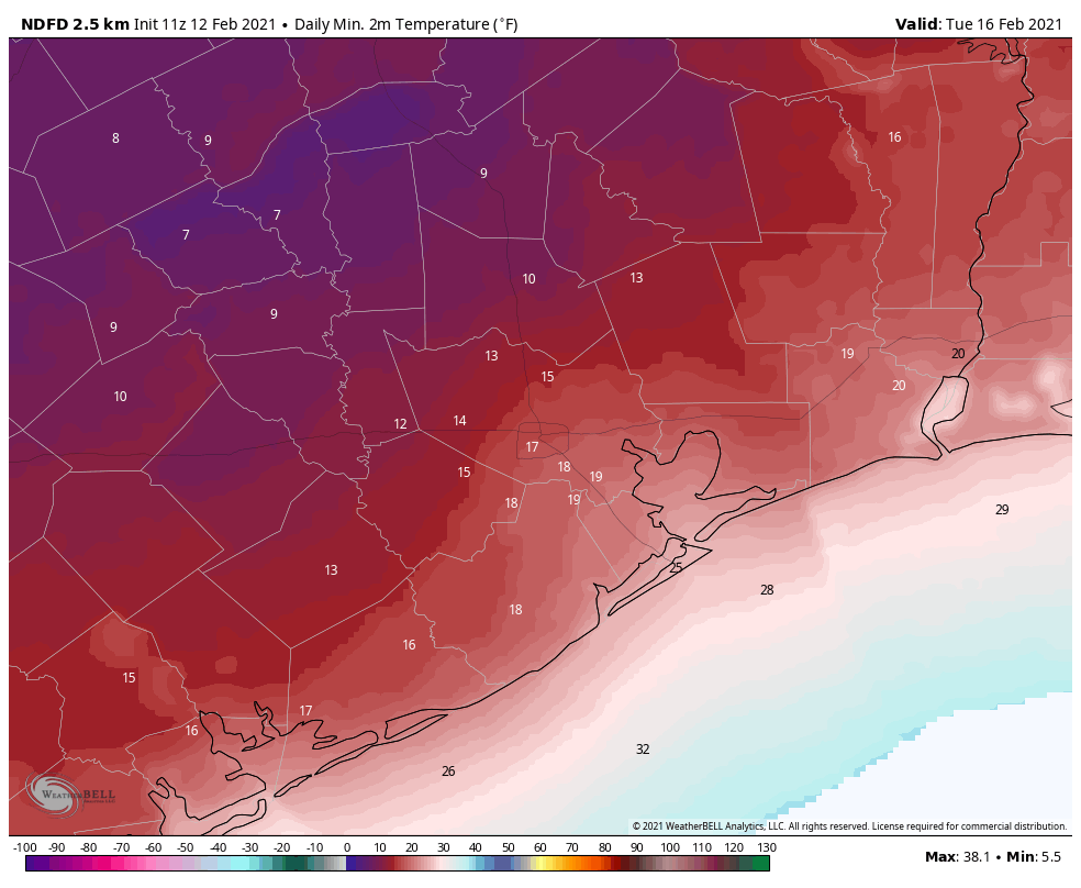
Yeah, that’s cold. We are expecting the city of Houston to bottom out at 15 to 20 degrees. The western and northern suburbs will likely fall to 10 to 15 degrees. Bay Area and coastal locations will be around 20 degrees, give or take. If we were to somehow see accumulating snow on Monday, you could probably subtract another 1 to 3 degrees from these values at least. The last time Houston officially hit 15 degrees? December 1989.
Tuesday will see sunshine at least! We should break out above freezing by late morning. The combination of the sun and temps in the mid-30s should allow us to melt most of Monday’s ice. We hope.
It’s worth noting that this won’t be just an extreme cold event in terms of temperature. It will also be so in terms of duration. Temperatures will likely drop below freezing in Houston on Monday before sunrise and not make it above freezing til mid or late Tuesday morning. This will easily be a 24 to 36 hour stretch of subfreezing temperatures for Houston, with a longer-duration north of the city. It has been over 30 years since Houston has seen this kind of cold weather. You absolutely need to prepare your home for the impacts. Reliant has provided some very useful advice below. You can also read more cold weather prep tips here, here, or here.
Later next week
I’ll be honest with you: I don’t even want to think about later next week right now, but the reality is, more headaches are likely. Another storm system is likely to impact the region on Wednesday into Thursday. This will also potentially carry a potpourri of precipitation types. Whether we see snow, more ice, or just plain rain remains to be seen. More cold will follow, and although we are unlikely to see the teens again, there is some chance we have another hard freeze (mid-20s?) by Thursday or Friday mornings. We’ll get more into that Sunday or Monday.
Note from Our Sponsor:
As Houstonians are prepping their attire, gardens, pets and plans for the freeze, Reliant wanted to share some tips on prepping your home to stay warm during the expected winter weather.
Stay Warm Tips:
Here are a few things you can do immediately to reduce energy consumption and still stay comfortable. Best of all, they’re simple and free.
- Let the sun in. Open blinds and shades during the day and remove any solar screens so the sun can warm your home.
- Check your thermostat settings. For every degree above 68°, you can expect a 3-5% increase in your heating costs.
- On vs. auto. Ensure the fan on your thermostat is set to “auto” not “on” to prevent it from running 24/7.
- Close heat escape routes. Be mindful of how often you’re using bathroom or utility room ventilation fans and ensure the damper on your fireplace is closed when not in use, as heat can escape from your home through these outlets.
- Set your ceiling fan to rotate clockwise. This helps force warm air down from the ceiling into the room to create a more comfortable environment in colder seasons.
Home Prep Tips:
A few home improvement projects can help keep your heating system from working harder than it needs to.
- Consider installing a Nest programmable thermostat. This can help you reduce energy usage by up to 15% without lifting a finger.
- Eliminate cold air leaks by weatherstripping exterior doors and windows. This is a relatively quick and inexpensive way to help save up to 10% on total energy costs. A few additional places to check are pull-down attic stairs, dryer vents and exterior wall outlets.
- Try the paper test: Open an exterior door, insert a piece of paper and close the door. If the paper comes out easily, the gap is too large and can contribute to cold air leaks.
- Get an annual heater tune-up. Make sure your furnace or heat pump is clean and in good working order, so that it can run as efficiently as it should.
- Check your insulation. Ultimately, a home without proper insulation and weatherization can lose up to 40% of heated or cooled air.
Check out more on winter weather prep and common causes of high winter electricity bills here.

Just an addendum to your comments: The 6z run to 90 hrs of European suggests a slightly earlier and snowier Monday event
Woohoo! Bring on the snow!
Yeah no, absolutely not lol. I don’t live in Texas because I want to deal with snow.
Do you think inbound flights to Houston will be impacted due to ice? We fly back Tuesday and I’m not sure how
well IAH can handle slick runways compared to northern airports
Imo, You’ll see significant cancellations through Tuesday if not Wednesday. Planes can be de-iced but besides the fact the airport has limited capacity for that, airport personnel have to be able to get to and leave the airport.
One additional tip: even though many/most won’t be driving much or at all during the worst of the freeze, check your tire pressure now and fill if necessary: tire pressure drops about 1 psi for each 10 degree (F) drop in temperature.
In December 1989 (referenced in the post) I actually flew in to IAH from YYZ/BNA where the source temp was -40 and 15F here (it actually felt warm) and so cold the 727’s engines wouldn’t start without an assist on the ground. Most of Houston was shut down for ice and even my family abandoned me to find a taxi. Made it in though and home for the Christmas holidays….so yes some flights will come in if the accumulation event has stopped.
Thanks Matt for the update! Thanks for keeping us informed!
This was supposed to be a warm and dry La Nina winter!! I want my money back lol!
Probably best if you just forget that forecast. Didn’t really work out so well.
I operate on the theory that we tend to get freezing precipitation events in the winter after getting hit with a hurricane. As active as last season was, this does not surprise me.
Great post – clear writing and useful advice. Thanks again Eric and Matt!
Matt, Thank you for sharing your insight and weather knowledge. You are my go to source for weather.
I’m out in Sealy, just went outside a couple of minutes ago and there’s already ice on a number of surfaces, the lid on the trash bin is frozen shut.
All this frigid cold air and we get stuck with freezing rain and busted pipes?? Shafted again!! What’s a girl gotta do to get some snow around here?? Bought the kids some snow boots and everything.
You’re living in the wrong area for snow. I hear where you’re coming from, but I’m super hoping there’s no snow, and if there is, it’s as minimal as possible.
Likelihood of IAH being g open Monday evening for inbound traffic ?
Just wait for 2021 they said. Things will get better they said…
I’m curious what factors determine whether precipitation falls as sleet/freezing rain vs. snow. I always assumed at temps like this it would fall as snow, but I guess that’s not necessarily true?
https://spacecityweather.com/wp-content/uploads/2018/01/winterwx.jpg
That’s a very helpful graphic!
The kind of freezing precipitation that falls depends on the temperature of the upper and mid-level atmosphere. If SCW says we’re likely getting freezing rain and sleet, that means they believe there will be a mid-level warmer air mass parked above the frigid air at ground level, so that the snow melts and re-freezes. This changes the texture of it because it loses the fluffy structure of snowflakes and becomes pellets or sheets of ice as it re-freezes.
Hey Matt, thanks for the update on the potential storm system, but your forecast sounds alot like the ones at KHOU or ABC13 right now which means the seriousness & sentiment seems to be about the same: “THIS COULD BE VERY DANGEROUS”
So driving conditions on Sunday evening should be okay? I’m in Spring. My teen is supposed to work until 9pm.
When will it be safe to drive I-10 E to Louisiana?
Thanks for the ceiling fan tip! I never thought about the rotation and how it affects air circulation.
Stay safe & warm everybody, from -45 degree Alberta ☃️…
And that’s Celsius!
Would there be any benefit to heading to Texas City to ride this out? It looks like it’ll be a few degrees warmer, and while we’d still be hunkering down, would there be less chance of freezing rain, or burst pipes/losing power in this area?
Regarding the Reliant tips about “energy savings:” I’m more concerned about my power going out and having no energy due to iced power lines. In such a scenario it makes sense to keep your house toasty warm so that you can endure a power outage and no heat for a while.
Yes, the forecast is grim and it will be a longer duration of cold. But, I’m going to look on the (possible) bright side that this will kill off the mosquitos. Hopefully.
And fire ants!!
Thanks for this update. We are in northwest AR trying to figure out whether to drive back to Houston Saturday or Sunday, or ride out the week here.Thoughts?
Anyone have an update regarding driving conditions on I10 west to San Antonio?
Keep an eye on http://traffic.houstontranstar.org/
Right now, cameras show clear roads as far as 183 and I-10
Thank you Eric and Matt for all you do. I have a series of questions this morning:
Will the dominant precipitation type sleet or freezing rain?
How much sleet and/or freezing rain will fall?
Will there be snow accumulation?
What is the exact timing of the storm? And by exact, I mean down to the second here in Katy.
How many power outages will occur? Once again, please focus your reply as it pertains to Katy.
Thank you!
Do you require a forecast by a particular street address or would your zipcode broken into 100 squares on a grid suffice? Each square has a unique forecast tailored to where it aligns to the zipcode – squares will be labeled A1, A2, A3…send in your street address & it will be triangulated to a grid coordinate and then modeled. Firing up the coal powered computer model now, please be patient as the vacuum tubes warm up.
Absolutely. I don’t make any decisions without Eric and Matt’s input. I’m still waiting on their answer on what weight motor oil I should use in my car.
this was supposed to be a warmer and drier than average winter. No wonder I don’t believe that things like climate change are for real. The last winter I remember being in the 20s in Houston was in 2014. The last snow I remember was in 2008. Also, in early 2007, I was in Bryan and I remember icy rain, and I had a car parked outside that was encased in a candy coating of ice. I couldn’t get into it for a couple of days.
climate change can also affect winter storms such as more snow, direction of storms and duration, etc. due to wetter atmosphere relating to rising temperatures. I agree that La Nina was supposed to make for a warmer winter but the atmosphere can be unpredictable especially for whats going on now for T X
Just because it’s cold in Texas for a week doesn’t mean the entire globe just froze. If you look at where the northern hemisphere’s heat is right now, it is warmer than normal over China, Greenland, Alaska, and Northern Canada, while cooler than normal over the central US, parts of Siberia, and Europe. Climate change driven by global warming is still a thing, it doesn’t stop existing when a cold front hits Texas for a week.
Thank you for all the info! I’m reminded in all this of a freeze warning about a decade ago where estimates vs. actual were skewed because we didn’t have a weather balloon in the Houston area to gauge higher elevation conditions. Is that still the case?
A friend texted me your tweet on staying home. Minutes later my boss emailed that we will be closed 3 days next week. Was planning on staying home regardless.
Can’t say i didn’t warn you all. I was the one worrying about how cold it would get this winter but i have to admit i was imagining more of a Jan 2018 type event. Never did I think it would be a Dec 1989 repeat. Damn this winter is crazy!!!