Good morning. For the upcoming period when we expect Houston to see better rain chances, Wednesday afternoon through Saturday, we’re now within the forecast range of high resolution models. This is important, because these models are better able to resolve the convective processes that produce rainfall. Typically, therefore, they tend to provide us with better insight into the timing, duration, and extent of rainfall.
If you recall, in our earlier posts this week, we spoke about accumulations of 0.5 to to 1 inch of rain, but based upon the latest modeling it now appears likely that many locations will receive more than this. Generally, that should be an excellent thing, because so much of the region remains in an exceptional or extreme drought.
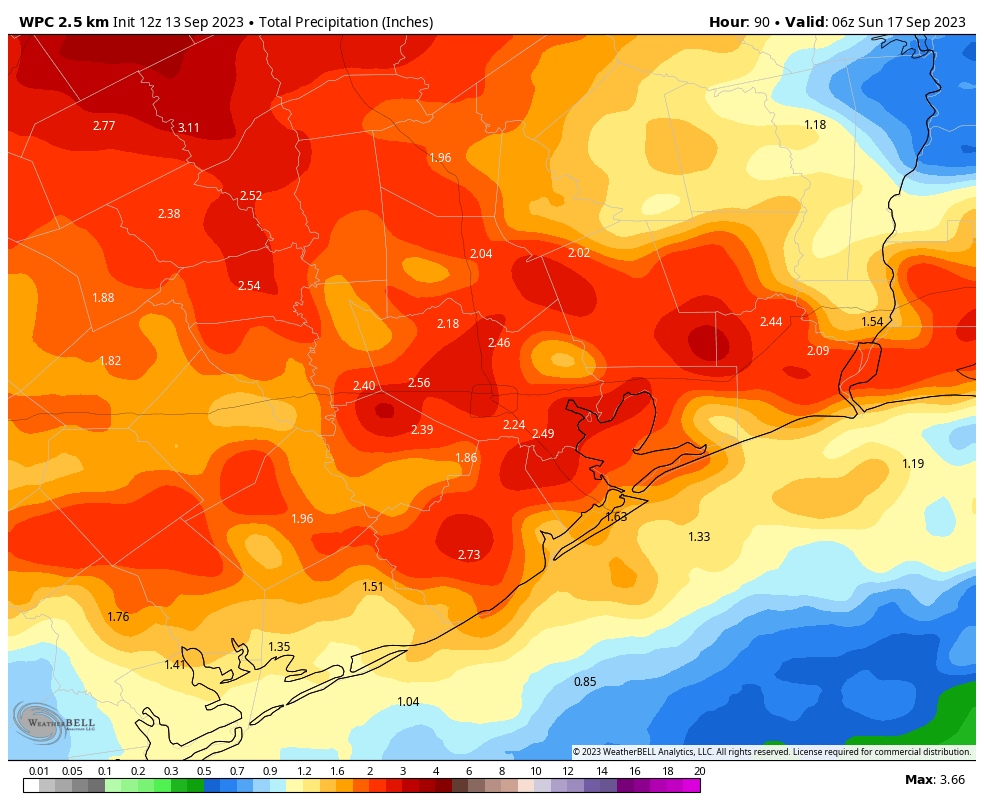
So how much rainfall are we talking about? Well, it’s still too early to have great confidence, because our best high resolution models are still only looking out to Friday, not all the way through the high-rainfall chance period. But based upon the latest data, the current expectation is that much of the area will receive 1.5 to 3.0 inches through Saturday.
All of this is being driven by the absence of high pressure, and a weak front drifting toward the area that will help perturb the atmosphere. Our confidence in some of the fine details remains uncertain, but overall the pattern is supportive of widespread, on-and-off rainfall. We cannot rule out some flooding, but conditions are not optimal for very heavy, sustained rainfall, so I don’t expect significant issues on area roadways.
Wednesday
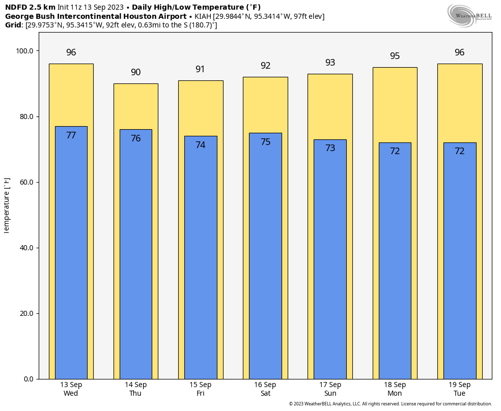
Today should be the last day that the region sees high temperatures in the mid-90s for a little while. Expect highs, generally, in the range of 93 to 97 degrees, with partly sunny skies. Rain chances are low today before the late afternoon and evening hours, at which point the favored locations will be between Interstate 10 and the coast. Rain chances will persist into the overnight hours, albeit with lesser coverage. Winds will be light, generally from the northwest. Lows tonight will drop into the upper 70s.
Thursday and Friday
It still appears that these days will offer the best rain chance for the entire metro area, likely around 70 percent. Skies on both days should be partly to mostly cloudy, and this should help to limit highs to around 90 to 92 degrees. Both days should see widespread, intermittent showers. Winds will be light, from the northeast. Rain chances will be less overnight, but still non-zero.
Saturday and Sunday
The first half of the weekend will see a continued chance of rain, with highs again in the low 90s. However, by Sunday morning we should start to see the influence of a weak front that will bring drier air into the region and largely end our rain chances. Highs on Sunday will probably be in the low 90s, with overnight lows dropping pleasantly into the low 70s.
Next week
With the influx of drier air, we’re likely to see highs in the mid-90s on Monday and Tuesday. However, humidity will be slightly lower, with nights a bit cooler. The front’s influence will dissipate pretty quickly, however. Therefore, most of next week probably will see highs in the low- to mid-90s, with some slight rain chances maybe returning by Wednesday or Thursday. Still no sign of a strong fall cool front yet, I’m afraid. We’re still at least 10 days out from that.
Tropics
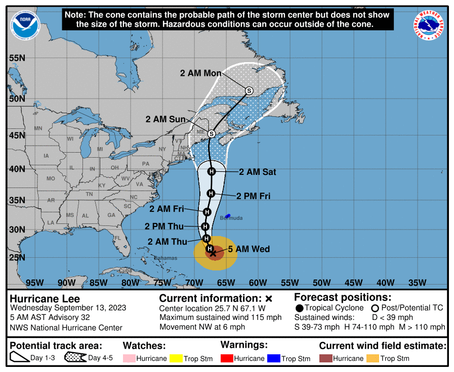
The good news is that the Gulf of Mexico is completely quiet, and likely to remain so for at least the next week or 10 days. Wind shear is really ripping out there, and that’s lovely to see in September, especially with sea surface temperatures so warm. Hurricane Lee, however, is increasingly a concern for New England and Nova Scotia. We’ll continue to have full details on Lee, and all the rest of the Atlantic basin, on our sister site The Eyewall.


Rain chances? Could they really materialize? Up to 3″ of slow, on-and-off, consistent rain and storms? You’ve made my morning and my lawn, my water bill, and the city infrastructure will enjoy the much-needed reprieve to this 65 day (for me) drought.
Hi, Saturday afternoon plans need to be solidified. What’re the chances for rain after 2pm?
Check tomorrows post for Saturday rain chances Kaylan.
Why does it seem like every rain chance this year has been accompanied by extreme winds (40mph+) and hail/lightning? It seems like the days of simple rain showers are gone.
I’m not seeing a huge wind factor in the upcoming rain this week — looks like 10 mph or less on the South side.
We had a couple weeks of pretty standard showers back in April and March.
Recently it has been since its these pop up showers that downburst when they form. Idk if the heat helps amp those up.
The concrete pour for our house foundation is scheduled for Thursday morning. You’re welcome.
I just washed both cars, so I’d like some credit for the upcoming rain too.
Please wash your cars too to increase the chances
“We cannot rule out some flooding…”
Considering that there are cracks in the ground in some places that are probably 12-18 inches deep and wide enough to step into, I’m going to say that it will take a LOT more than 2-3 inches of rain for there to be any flooding.
I think they might be referring to potential street flooding. If 2 to 3 inches of rain falls in a short amount of time this can still overwhelm low line roadways especially in areas that don’t have the best drainage even in a drought. But yeah in a grassy land area, it would absorb 2-3 inches up like a sponge. It wouldn’t even be enough to close the cracks in the ground. I’ve seen it before many times.
Very true, 2-3 inches dumped very quickly on Houston right now with our dry and cracked ground would lead to significant erosion and the ground wouldn’t get helped as much as long, gentle rain. However, if we got 3″ in a half hour or so in the galleria area, there would be streets shut down. Simply too much rain too quickly for the storm sewers to keep up.
Bring it on!! I actually want to see the Eyewitless News mobile response teams deployed to show you how much it is raining on a side of town you never go to. That’s assuming they remember how to do it.
Hahaha! I might go out and dance in the rain! The poor trees and grass really need it.
I know this won’t get us out of the drought, but I wonder if it will be enough to ease the water restrictions.
If it lets people cut back on watering their lawns and foundations, it will provide an immense benefit towards easing the water restrictions.
Highs in the low 90s on Thursday! Better get ready to bundle up folks!
“Some people walk in the rain, others just get wet.” ― Roger Miller
If we get 3″ of rain from this evening to Saturday I am liable to be playing in it….
Be careful driving if it actually does rain. Whenever it hasn’t rained for a while it’s normal for Houston drivers to react to the first drops of water on the road with confusion followed by sheer terror.
I agree with your sentiments of urging caution while driving, however there are actual scientific reasons for it – When it rains after a long dryspell, any oil on the pavement (accumulated over the past two months) from cars leaking it or burning it, rises to the top and makes the concrete and asphalt even more slick than the rain alone.
Eric, just a comment about the app…the Home Screen there is showing me the weather for 9/8, not today. Not sure if it’s a glitch or I need to update the app.
Never mind lol. It fixed itself.