One of the best things about Space City Weather is the people who read it. Anyone who writes regularly wants to feel like the audience is paying attention – and it’s even sweeter when they’re talking back. SCW is more than just Eric and Matt: It’s you, too.
And you have questions. Lots of them. We enjoy turning your queries into posts, which happens a lot. Now, it’s going to happen more. We’re starting a monthly SCW Q&A feature, in which Eric and Matt will tackle a handful of questions you’ve asked them recently.
Got a question of you want answered? Leave it as a comment here or on one of our many social channels (we’re everywhere!), or hit the Feedback button on the blog’s home page.
Q. Do you think we’ve seen the last chance of frost? I’m itching to get plants in the ground.
A. We received a couple of questions along these lines. We are now past the “average” date of the final freeze for pretty much all of the Houston metro region, except for a few outlying areas like Conroe and Montgomery. So historically the city’s odds of seeing another freeze are below 50 percent.
But I think they’re far lower than this. We’ve clearly entered a more spring-like pattern, and there is no sign of a super-strong front in the next 10 to 14 days. So I’d say our chances of seeing another freeze in the Houston area this season are 10 percent, or less. It could happen. The city has recorded freezes in early April before. But it’s very unlikely.
–Eric
Q. When do you expect that the yellow pollen will be back in Houston again? Thanks!
A. It’s baaaaaack! Allergy season is now in full swing. Usually, we’ll see little bumps in pollen through January and February as we get periodic milder weather. But we never see the full force of pollen arrive until usually the last week of February. It appears that began last Friday. In fact, if you look historically, you can see this in the City of Houston’s tree pollen count. The chart’s a bit messy because data is not taken on weekends or holidays. But you can see the general trend.
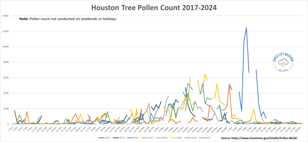
Since 2017, Houston’s peak pollen day has occurred in March, varying between the 6th and the 31st and averaging around St. Patrick’s Day. Pollen typically builds in the first half of March, peaks, and then slowly tails off before a more dramatic drop heading into April. Notice how on the chart above 2021 stands out for how short pollen season was, thanks in part to the mid-February freeze. With a potentially extended spring this year, we probably won’t get so lucky. Whatever the case, the next three to five weeks will probably be rough for those with pollen allergies.
–Matt
Q. You’ve talked about how it’s silly to predict hurricanes too early. But at what point does a season prediction start to become credible, in terms of timing?
A. This is a really good question. Seasonal forecasting for hurricanes is a challenge, whether you do it in January, March or May. This is part of my day job in the energy industry, and it remains the most elusive in terms of consistency, particularly when you get into other variables like temperature or rainfall for a season. But from the standpoint of hurricanes, seasonal forecasting is actually not half bad when you begin to see outlooks emerge in March. Colorado State University issues one of the most publicized hurricane outlooks, and this year’s first iteration comes out on April 4th. Anything prior to that can be hit or miss.
Raw modeling of hurricane season forecasts is occasionally good, occasionally bad. For humans, trying to predict El Niño vs. La Niña and the amplitude can be a challenge this time of year because of the inherent “spring predictability barrier.” That’s one of our best signals for determining directionality of a hurricane season (busier or quieter). But some years are easier than others. The current thought among most meteorologists I know and follow, as well as my own independent thinking, is that we are almost certainly heading into a La Niña this summer. That, combined with continued exceptionally warm oceans globally (a global marine heat wave) seems to imply that virtually no one should be forecasting a quiet hurricane season this year. We wrote about this in detail last week at our companion site The Eyewall.
But as far as firm concrete numbers? Late March and early April offers a viable first guess, with some adjustments in May and even June. That said, what no one is really, consistently good at on a seasonal scale is predicting where storms will go. So regardless of forecasts, it’s important to remember to prepare for every hurricane season as if it will be the one that impacts you.
–Matt
Q. I have a question regarding how clear Houston appears following a cold front. I imagine it’s because the wind blows the smog and pollution away. But what’s the science behind that? Does it also have something to do with our humid climate?
Well, you have pretty much answered your own question!
First let’s characterize the haze that typically makes for less clear air. Haze is caused when sunlight encounters tiny pollution particles in the air. Some of this light is absorbed by particles, and some is scattered away before it reaches you. More pollutants mean more absorption and scattering of light. In Houston we have plenty of pollutants in the air, which increases the likelihood of haze. But weather plays a role as well.
Fronts typically bring blustery conditions, and these winds clear out air pollution at the surface. In addition, warmer air in Houston tends to be more humid. So think about a warm, summer day in Houston: It’s humid, winds are typically light and its partly to mostly sunny. These are ideal conditions for the formation of haze. Conditions in the wake of a good front: cooler and drier air, and windy conditions, are kryptonite for haze.
–Eric
Q. I love the site and love the new(-ish?) logo! Any chance you’ll get that on a coffee cup at some point?
A. I’m glad you like the new design! It was time for a refresh. The original design, depicting the space shuttle carrier aircraft flying over the city of Houston, dates to October 2015. At the time I was in a rush to create the site in a couple of hours. I grabbed the image because it was a free NASA photo and it captured both the elements of “Space City” and “Weather.” But it wasn’t professionally done. I love the new look, and especially because it features the International Space Station, which is flown right here from Houston.
As for coffee cups, that’s a great suggestion. We’ll be sure and add those to our annual fundraiser. That takes place in November when we encourage people to buy merchandise and donate to support the website and our app.
–Eric

Thanks for doing this it is a great addition to the already great things you do!!!
Would you discuss the difference between monthly rainfall surplus/deficit and the drought monitoring?
What is the prediction for Saharan Dust this year?
Q&A how nice. I check your forecasts every morning. B
I love the new Q and A. Very good details to current concerns. I’m looking forward to the new coffee mug, too.
Love the Q&A guys.
I would be interested to know if there is ever a time when there is neither La Nina or El Nino – like it is ever normal?
Yes — these are called ENSO neutral conditions.
Have we had one of those ENSO neutrals in recent years? Maybe I have a selective memory, but it isn’t sticking in my mind (or the newspeople don’t like to talk about neutral conditions).
LOVE THIS WILL BE SENDING SOME QUESTIONS SOON.
I also love this Q & A. Thanks so much!!
Best darn weather people anywhere.
It seems like ever since the first of the year, conditions are much more consistently windy than I remember in past years. Is it just me or do statistics bear this out?
We live close to a major freeway. The severity of the noise level and the direction from which it comes seem to vary with wind and humidity levels. Can you explain that further?
I am a bit confused about the recent El Niño and upcoming La Niña. El Niño started last June and gave us the hottest and driest Texas ever when I thought we were supposed to expect cooler and wetter. Now we are facing La Niña and people are saying it is going to be hot and dry. Was last year’s event on outlier or is climate change changing what these cycles produce? Would not La Niña bring hurricanes which would make things wetter? Just hoping that THIS summer is not worse than last summer.
La Nina and El Nino only have a relatively predictable affect on the weather here in the cooler months. I have no idea if there is a correlation between El Nino or La Nina and hot dry summers, though it seems to me that perhaps neutral conditions, or (hopefully) transition periods from El Nino to La Nina, are the best for cooler and wetter summers.
From my personal observations there really isn’t much of a correlation with what the weather will be like during El Nino or La Nina summers. It can go either way. We do have a higher chance of seeing alot of rain during La Nina summers because there is more favorable conditions for tropical development in the Gulf. But it is still a coin toss for what will actually happen.
Also Esno neutral summers can go either way as well.
Thanks for all the hard work Ladies and Gentlemen! Have a wonderful Spring.
-Delgado family
After the last three years, I dread summers now. And drought. I checked the long range forecasts on weather.gov, and it looks like another extreme summer is probable. Do you have an opinion? I am trying to figure out if planting anything is going to be worthwhile. Thanks.
I think this is going to be an awesome addition to SCW! Thanks, and keep up the great work!
Thanks for doing this. Fun & informative. Look forward to the ongoing conversations.
“That said, what no one is really, consistently good at on a seasonal scale is predicting where storms will go.”
With a lot of appreciation for Space City Weather and as someone who follows this page every day, please know that this really isn’t true anymore. I really really encourage you to check out the past years of Hurricane forecasts from Wesh2 news. They publish Hurricane hot spots on March 1st every year and leave them up so you can verify their track record. Their accuracy speaks for itself. In fact, they even do post season analysis to see what their misses were so they can learn how to adjust their forecasting for upcoming years. For example, in 2023, all their hot spots except one received a hit and there were no hits in any areas that they didn’t highlight. In 2022, there was a weak system (a tropical storm I think), that made landfall outside their hot spots, but all the other storms landed where they were forecast. That can’t all be coincidence!
I’m not saying that to tear anyone down, but rather because it would mean a lot if Space City Weather and other forecasting entities could learn and adopt this method so we can all be better informed come Hurricane season.
Thank you for this QnA! Follow up questions if you can get to them:
1) “Houston has plenty of pollutants in the air”. Which are the top few cities in the country with the clearest air?
2) Spring allergies – which are the top few cities with least pollen/seasonal allergies in spring?
(Reason I ask is I’d like to factor in this data if we consider a move!).
Thank You
I’m a big fan of Q&As
My question is related to history and climate. In southeast Texas, how has the climate changed over the last 10,000 years? Was this area dryer, wetter, more trees, more prairie? How did this effect how people lived?
Always liked your hasty website design with downtown and shuttle image. Gave your site a homegrown personal feel with photo. I remember shuttle flying over Houston back then so that was fun memory looking at your site too.
The new design is posh and sign of your growth and success. Maybe keep the old photo of vintage website for anniversary celebration lookbacks that are sure to come.
Well done you
I’ve often wondered if there have been statistical analyses done on the accuracy of early and late season hurricane forecasts from various entities, to see just how much more accurate than random they are.