Good morning. Thanks to Eric for covering me the last few Fridays as I took some time to step away from weather forecasts and explore Utah, which is an absolutely incredible place. And there was snow, for real! Anyway, it’s good to be back in Houston, and it would be better if the Astros were to win tonight. Let’s do some weather, as it is an active, changeable period the next several days.
Today
An area of heavy rainfall formed overnight southeast of Houston dumping nearly 7″ of rain (including 4.5″ in an hour) near Friendswood along Clear Creek.
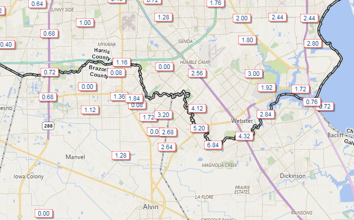
The heaviest rain has shifted north, but Clear Creek may still rise a bit close to bankfull in spots but not out of banks. Street flooding is likely to continue a bit longer this morning in this area.
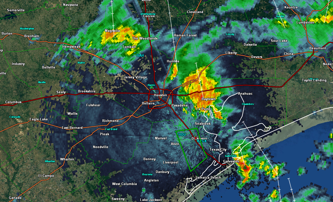
So what does the rest of today bring? We’ll probably see continued periods of rain and thunderstorms east of Houston south to near Galveston. Rain will come in spurts, but it could be heavy at times. I think the heaviest will be east of where the serious rain was earlier this morning, and the rain should be intermittent enough in places like Friendswood, Dickinson, and League City to not cause any further serious problems. That said, there may be some pockets of street flooding issues in parts of Chambers or Liberty Counties today, but they’ll probably be isolated. Elsewhere, keep an umbrella at the ready. Expect isolated to scattered showers and storms in the area, especially through early afternoon.
Temperatures will be held back a bit with clouds, but since we’re starting much warmer than yesterday, we should crack the lower 80s this afternoon (a few places west of the city may do middle 80s). We may see a few showers around this evening or overnight, but far less coverage and intensity than this morning. Most of us will stay dry tonight.

Saturday into Sunday
So Saturday is probably the pick of the weekend. Yes, we’ll have some scattered showers around Saturday afternoon, but they’ll mostly be very widely scattered. If we do see more persistent showers or storms tomorrow, they’d probably be west of Houston, out toward Katy, Brookshire, or even further west. A good chunk of us won’t see any rain during the day Saturday. Have an umbrella handy, but you might be able to get through the day without having to open it unless you’re west of the city. Temperatures will start Saturday in the unpleasant lower 70s and top off in the middle 80s. It’ll feel a bit like late summer.
The cold front we’ve told you about this week is still on target for Sunday. The timing has meandered around a bit, but it looks like we’re settling on the front dragging through the Houston area between about 8 AM and 2 PM, if not a little earlier. It will probably have a line of thunderstorms and locally heavy rain with it as it pushes through. This won’t be anything too serious (severe weather isn’t expected right now), but there could be a few gusty storms embedded within the line.
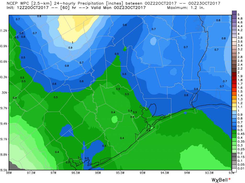
We may see another 0.50-1″ of rainfall as the front moves through Sunday, and it could rain heavily for a short time. But this will be a progressive, steady moving front, and it clears the coast before Sunday evening. Sunday morning plans may be wet, but Sunday afternoon plans should be fine in most places. We should see much, much drier and more comfortable air arrive by Sunday afternoon and evening. Temperatures will top off in the lower 80s Sunday. We’ll see cool, pleasant, albeit breezy conditions Sunday night with a lot of 50s populating the area by Monday morning.
Next Week
We’ll see absolutely beautiful weather next week. Monday looks near-perfect, with highs in the upper 70s and a breeze. After another pleasant Monday night, we’ll see another cold front on Tuesday. This one should be a dry front, and it’ll usher in a reinforcing shot of dry and cool air for the middle of next week. That means Wednesday will be sunny, breezy and cool, with highs in the middle 70s. Overnight lows Wednesday night into Thursday morning could bottom out in the 40s in a few parts of the area. We will probably see warmer temperatures beyond that, but there are signs of another front by the weekend.
Simply put, next week looks glorious. Hope you’re able to enjoy it!
It was flat out SCARY this morning on the bay!!! The thunder was so loud and close, it rattled and shook my whole house! The rain was SO hard, it had my house shaking too! And, of course everything electrical went out….. By the time I left my house for work headed to the Galleria, the sky was out on that side of town!! Still took me nearly and hour and a half to get in! I wasn’t that scared during Harvey!! I’m exhausted!! LOL
I ❤️ Space City Weather. GO ASTROS⚾️⚾️⚾️
Overall, got 5.2″ in about 2 hrs. around Ellington. The aircraft for WOH got a free washing.
The PWS in our subdivision recorded 5.8″/hr around 5:19 this morning (same time as I woke up, for some reason 😉 ). That’s insane. That’s almost as hard as it rained at times during Harvey.
The weather in this city is about to drive me crazy!
Hi Eric! I’m going to the Something Wicked festival next weekend at Sam houston race park. What do you think the weather will look like next Saturday/Sunday? Will it be chilly in the evenings?
Sounds like the front just push through just in time for a beautiful Sunday afternoon at the Dynamo game!
Dry as a bone in the NW part of The Woodlands today, after a short and weak shower around 5 AM.
Sounds like good news. Let’s see how long it lasts.