If you’re only interested in Houston weather, you can skip this post. We are not going to see much rain over the next 10 days, and temperatures will generally be pleasantly cool for early September. However, we’ve had a lot of requests from readers to continue coverage of Hurricane Irma, due to the significant threat it presents to the United States. (Already, with winds of 185-mph, the storm is the second-strongest in the Atlantic basin on record). So that’s what we will provide here.
Having looked at the forecast model guidance that has come out during the last two hours, the we can have pretty high confidence in the hurricane’s track through about Friday, when it will be in the vicinity of Turks and Caicos (a beautiful area, which I hope survives this storm). After that I want to highlight three possible scenarios, neither of which I have particularly high confidence in as so many unanswered questions remain: When does Irma find the western periphery of the Atlantic high pressure system and turn north? Does it turn northwest, due north, or northeast? And how much does the storm’s center interact with Cuba? All of these questions will have profound effects.

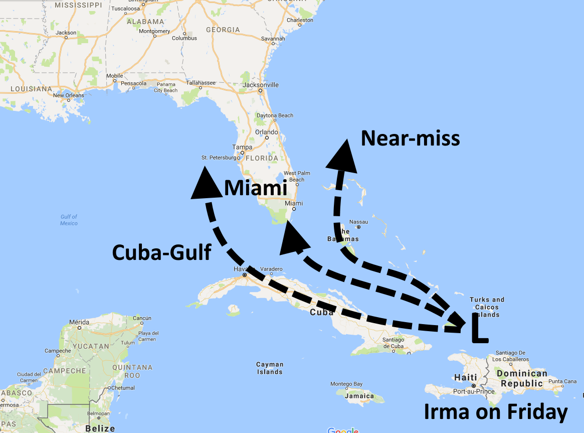
Cuba-Gulf (35 percent)
Under this scenario, Irma travels further west before turning north, and spends more time over Cuba. This is obviously very bad for Cuba, but also should weaken the storm as the island has some mountains with elevations above 1 mile. This would bring a weaker storm into the Eastern Gulf of Mexico, and thereafter the center might go anywhere from Pensacola to the Everglades in terms of a final landfall and move over much of Florida. If Irma were to spend more time over the Eastern Gulf (where water temperatures were unaffected by Hurricane Harvey) some restrengthening would be possible.
Miami (35 percent)
In terms of consequences this scenario is the most catastrophic. Here, Irma may remain over Cuba only briefly, or not at all, allowing for a very strong major hurricane to move into the Florida Keys, and then the Miami area. We might end up with a situation where the strongest winds and surge hit the lower Florida coast, from Miami to West Palm Beach, some of the most valuable real estate in the country. Very, very bad.
Near miss (30 percent)
In this case, the “near miss” refers to Florida, but not the Bahamas. A decent chunk of both the GFS and European model ensembles hold to this scenario, where Irma moves toward the Bahamas, but makes a northern turn before reaching Florida. In this case, the mainland United States would remain on the side of the hurricane with lesser winds and storm surge. For the state of Florida this scenario might still be bad for some areas, but the state would avoid a catastrophic blow.
We’ll have an update on Houston’s weather and a new look at Irma’s forecast early on Wednesday morning.
Yes we are really interested in Irma.. many friends in Florida. Came here to get some info from a reliable source!
Me too. Sitting here in Katy TX worried about family in Boynton Beach (West Palm Beach) FL. Thank you!
You’ve had a rough time. Hope things are getting better for you.
Are you planning to update this? You said it is reliable…yet it is now three days old. With weather that changes by the hour….3 days is really really out of date
What about my island of Puerto Rico?
Same question…
Would like to get your professional thoughts on this as well.
Looks like it’ll catch the southern edge of the storm on Wednesday. That’s in the “pretty high confidence” section, so hopefully that means the storm won’t veer south and hit PR directly. Hoping for the best for you!
Yes, friends and family in Puerto Rico. It’s a US territory so updates would be appreciated! thank you!!
Same here.
Any thoughts on “José”? Thank you very much.
Thank you Eric! I really appreciate your thoughts on Irma.
Many Houstonians have family in the DR. Any news on what the DR can expect?
Thank you Eric! My family is in FL and they are all very concerned about where the storm is going.
Thank you for the continued updates. Y’all are my first-stop for weather news now. We were so thankful for your reporting during Harvey.
Is the Miami scenario potentially an Andrew event?
Thank you for covering this storm. I have friends and family through out the state of Florida, and I trust your forecasting.
30% seems too high probability for near-miss given it’s expected westerly movement over next couple
Could you include coordinates on the storm? I have a tracking chart in my office and people come to look at it. I’d like to have it updated for them
. . . See Hurricane Irma official NWS bulletins and maps, at
hurricane.terrapin.com/ATL-11A and for a good satellite view,
follow http://www.goes.noaa.gov/HURRLOOPS/huwvloop.html
Follow radar progress starting with
radar.weather.gov/radar.php?product=N0Z&rid=JUA&loop=yes
(use arrows at upper left to go to Adjacent Radars of Miami or
Key West in days-to-come).
The Cuba-Gulf scenario may be catastrophic for the Tampa Bay area (Tampa-St. Petersburg-Clearwater). The Washington Post published an extensive article on the problems there in its July 28, 2017 edition (https://www.washingtonpost.com/graphics/2017/health/environment/tampa-bay-climate-change/?utm_term=.e9cdc9111c85). Let’s hope it doesn’t happen.
Thanks, Eric. My two college age daughters recently moved to Disney World as part of the Disney College Program. I feel lost without your constant coverage! Having just survived Harvey here in Houston I have to say we are #sooverhurricanes.
We are too.
Thanks Eric. Friends, family, and business associates in the path no matter where it goes in Florida. So good to keep abreast of it.
You’re welcome.
I’m from Nassau, married to a Coastie, living in Houston. My parents, brother, nephews, many other friends and family are there. And they don’t evacuate. I appreciate your updates, and my family there are following you as well.
You discount the “up the middle” option..:
Could you explain why you feel that is not a very likely choice?
Your options are the most positive for MY area of FL so they are attractive.
Just hate to hope and be disappointed…
I very much appreciate your updates, I have family and many friends in Florida so the Irma updates are helpful to us. If you could keep us up to date we would greatly appreciate it.
Could you maybe include or add a post regarding Puerto Rico? Those of us with family there, who are still coping with the aftermath of Harvey would like some information about PR. Thanks.
Dear friends in Puerto Rico, Bahamas, and Cayman Island. They have to go to Miami for major medical needs. Please include island updates if you can. Trusting your news above all others. So appreciative.
Thanks for this! I’m considering flying to FL myself later this week to extract my grandmother from West Palm Beach for the weekend to stay with us in Texas.
I live in WPB. It would be very difficult to get a flight into PBI at this point. I can’t find any flights out.
We will be completely boarded up by Friday and hoping for the best. We did well with Matthew.
Hi Erick, I live in Houston and followed your posts, all throughout Harvey and you were incredibly spot on. Thank you so much for all the information that kept us a little more sane through the whole ordeal. I have a question with Irma though. We are supposed to be leaving on Saturday, sept 9th to the Cayman Islands. Would it be wise to reschedule the trip? Or will the Cayman Islands be spared?
Thank you!
Thank you for the accurate posts.
Hope of hopes —
Our cold front stalls from the Yucatán to the eastern Gulf, forcing Irma to the open Atlantic as a “fish storm” that also misses Bermuda. This also blocks any mischief from the south moving toward TX / LA
After reading the great posts you had for Houston, you have our attention. We are in the Carolinas, lived through Hugo, and hate the thought of experiencing the same. We will active readers of your comments. Thank you for all your work.f
What are the odds Irma destroys Mar-a-Lago and spares everywhere else? Asking for a friend…
Is there a reason everyone is so confident that Irma will turn north and hit Florida instead of continuing on through the alley between Cuba and Florida and heading for Texas like Rita did? Considering that’s happened before with a hurricane I’m surprised it’s a scenario no one is even mentioning, not even to mention why they think it probably won’t happen.
I believe it’s because we have a cold front coming through Wednesday that will push the hurricane east. Eric has talked about it several times in his previous posts on the tropics.
well the big “cold front” seems to be fizzling. lows 68 and high upper 80’s. not much wind. Hardly a blue northerner. And large storms like that can create their own environment and don’t always react to rivers of air. I am hesitant to at least have a plan in place
Thank you for this and all of your work during Harvey!
What about my friends in pinta gorda?
What about pinta gorda
Why is this hurricane season producing such strong storms?
Still have my guard up. Early Harvey forecasts were for a tropical storm to move into Mexico. Obviously that didn’t happen. It rapidly intensified and then moved northwest. Now I see the much publicized “cold Front” seems to be loosing steam, latest forecast lows of only 68 and not that much north wind. So if we were relying on that front to keep it away. I would still be slightly concerned. Also storms that big don’t always react to minor rivers of air and can create their own environment and do what they want. Some of the models now say it might go under Florida and get into the Gulf. That is a bit concerning, especially if we are relying on the “big turn” to the north
thanks for posting this info guys. I live on the Space Coast (Melbourne) of Florida so I’m well into Hurricane Irma prep at this point. The “near miss” scenario of the latest GFS could result in Irma running up the coast in a ‘buzzsaw’ fashion much as Matthew did last year, only stronger. Reminds me of Floyd also, last time I recall at Cat 5 just off our coast. Please keep posting!
http://www.nhc.noaa.gov/gtwo.php?basin=atlc&fdays=2
If I understand correctly, there is storm (13) in the gulf, headed east. There is Irma headed west, possibly turning north. There is a tropical depression, Jose, headed/following/trolling toward Irma.
Is it likely that all 3 of these meet and wreak major havoc? I haven’t done the math to calculate winds, currents, etc. I’m am 3 levels below novice 🙂
Has this threesome ever happened before?
To my amateur eye, it seems we are in some weird weather event, weirder than usual for the season.
Thanks so much for all you do. I really appreciate your forthright approach. Although I am near DFW, I do have family in Houston and have lived there for about 25 years.
Best wishes to all.
A tropical cyclone menage a trois sounds dangerous
Thank you for covering Irma! Eric, you and Matt have been so faithful to keep us updated on our weather. We relied on you during Harvey and are grateful for your clear and concise reports. My mother-in-law, who lives in Florida, also follows you. Thank you for Irma coverage for her.
As a long time Ars reader and Floridian, I have this site flagged for the coming week. Thanks for the coverage, Eric!
Any thoughts on the best and worst case likelihoods for Tallahassee, FL? Nobody I know here is sure about needing to get together go-bags or if they should just prep to hunker down for a few days without power like we usually do..
Praying for everyone in Irma’s path, no matter where they are. I cannot fathom the additional damage another hurricane would bring to the US or islands along it’s way.
Well, since I was in Houston fir the hurricane, only to go back to Tampa two days ago, I’m beginning to wonder why hurricanes seem to be on my case. I hope you continue to cover Irma. Good work!
Tom, 🙂 100% joking here — don’t come back, since you seem to be a storm magnet 🙂
Eric,
Thank you so much for tracking Irma. We survived (Kingwood) Harvey and you were with us, helping us getting through this. Now, we are tracking this, since my mom lives in Miami Beach and I have close friends in San Juan. Any chance that you have a magic wand in your arsenal to make this one disappear?
Thank you so much for you coverage
This is very likely going to be bad. Very bad. Record water temperatures in that part of the Atlantic is giving this storm insane amounts of fuel. Thus the literally cataclysmic power we see today. This could make Andrew look like a cakewalk and be far more devastating than even Harvey. This, I am afraid, is the new normal.
Do you know how Irma will affect the Dominican Republic? My best friend is a teacher there and has never been in a hurricane.
. . . Right-on, Jon! The high pressure behind the cold front may just merge with the Atlantic high-pressure ridge, filling in the weak trough with the front, providing no north-turn attraction, and extending the WNW track towards perhaps Louisiana. I’ve been telling people this storm likely will be worse than Andrew — “We had Harvey in Texas; Irma will take care of the rest of the Gulf Coast!” And on top of all that, what if we had a triple-whammy, of a California or northwest-coast mega-earthquake (new and full Moon alignments with the Sun put maximum gravitational stress on the planet). Could the USA economy handle it all?
. . . On a more positive note, there’s the Houstonian Spirit of Cooperation:
“No man is an island”
quote by English poet John Donne, year 1624 C.E.
“— even in Houston!”
quote by meteorologist Alán Alán Apurim, year 2017 C.E.
. . . Well, 23 hours and 37 minutes after my “triple-whammy” post,
the 8.1-Richter-scale quake did hit, but further south than I feared.
. . . Meanwhile slow-moving hurricane Katia will drift out of the Bay
of Campeche to expend on Veracruz and dampen the glaciers of the
third-highest mountain in North America, Citlaltépetl, a volcano in
its path that towers 5,636 meters high. Hurricane Jose follows be-
hind Irma, threatening the little-that’s left of Barbuda et al… and
the predicted track of Irma up the center of Florida has been shifted
slightly westward. Any more, and the storm will be drawing heat
from Gulf waters and not weaken as much, though upper-level shear
may be the “saving” factor to keep it below cat, 4 or 5! Keep up-to-
date with bulletins and charts at http://hurricane.terrapin.com