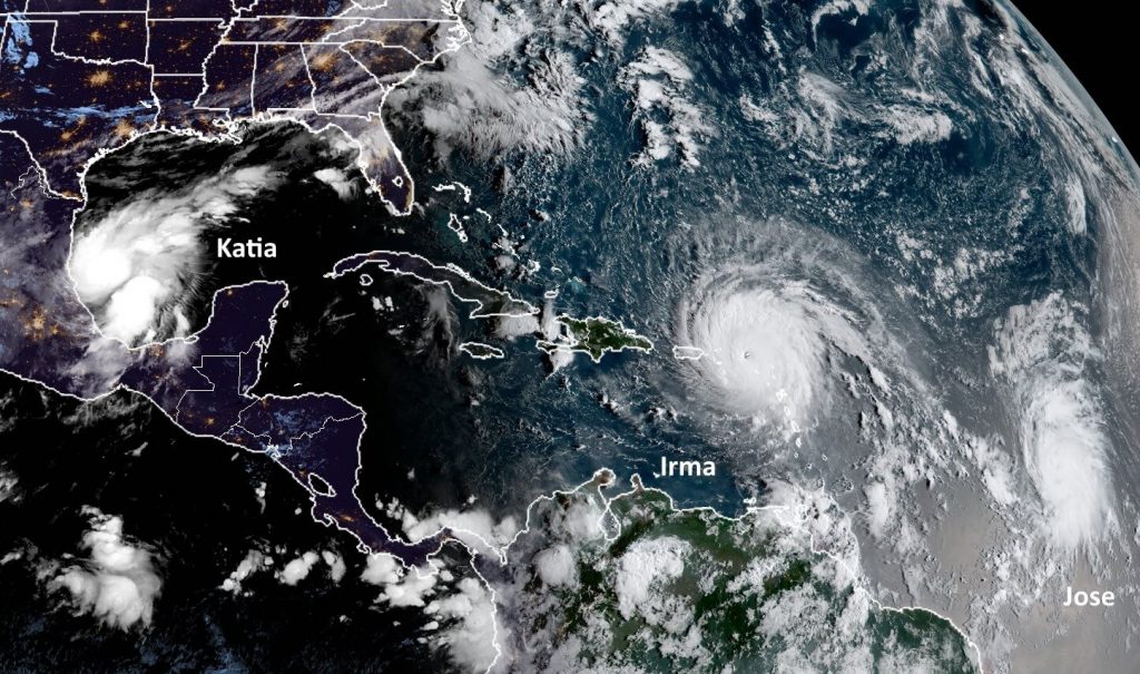
This post will provide a brief forecast for the Houston area, which really has no weather concerns at all over the next week or 10 days, and then discuss the tropics, where two other storms have developed in addition to Hurricane Irma. With 185-mph winds, Irma continues to pose a grave threat to the Caribbean Islands and southeastern United States—but the forecast is a smidgen brighter for Florida this morning.
Houston
Some isolated showers popped up earlier this morning ahead of the cool front, and a few more may develop later this morning and early afternoon as the front moves through the metro area. Nothing to be concerned about. After this we can expect amazing weather through at least Sunday or Monday—with mostly sunny skies, highs in the 80s and lows in the 60s. High temperatures may finally get back up toward 90 degrees by the middle or end of next week, but rain chances will remain near zero.
Irma
The storm’s central pressure has continued to fall this morning (another measurement of intensity) but its winds have held steady at 185mph as it approaches Puerto Rico. The eye of Irma should pass just to the north of the island today. Here’s a look at the official forecast released by the National Hurricane Center at 4am CT:
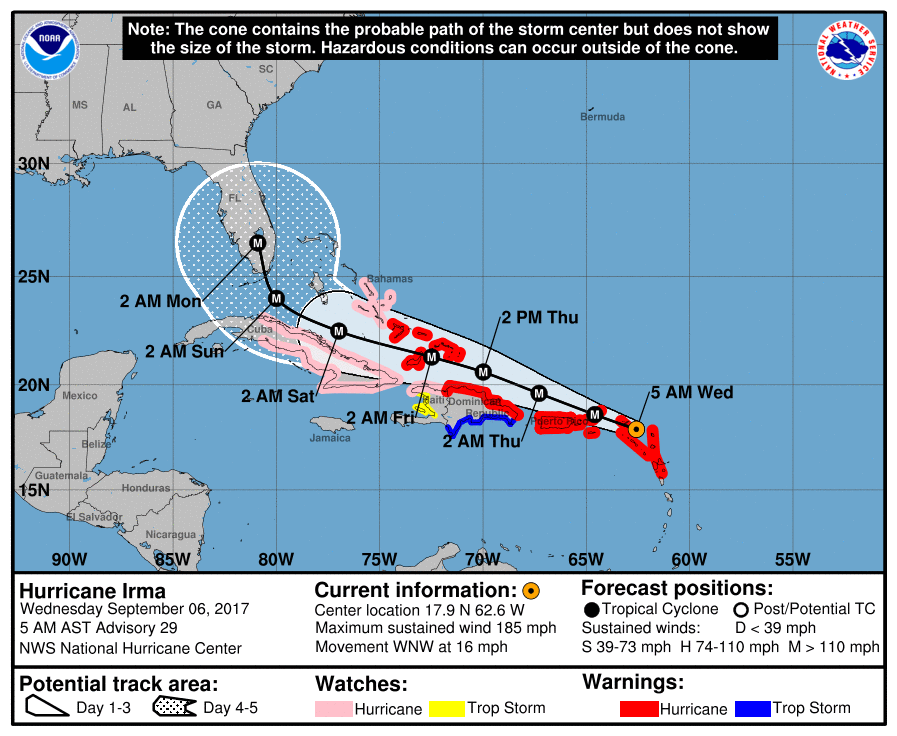
Clearly, this is a devastating forecast for Florida, essentially bringing the storm’s very worst winds and surge to an area from Miami to West Palm Beach. The storm would then continue up Florida’s spine, continuing to deliver punishing winds and waves to the eastern half of the state. However, it is equally important to note that we are discussing a forecast for conditions five days from now. Although hurricane forecasters are pretty good with forecast tracks, the average five-day error is still about 200 to 250 miles in terms of track.

That’s a pretty good bit of uncertainty, and there’s no reason to have high confidence in Irma’s track five days from now. This is especially the case as the models have shifted somewhat eastward overnight. Here’s a look at the latest ensemble run (06z) of the GFS model, which came out this morning.
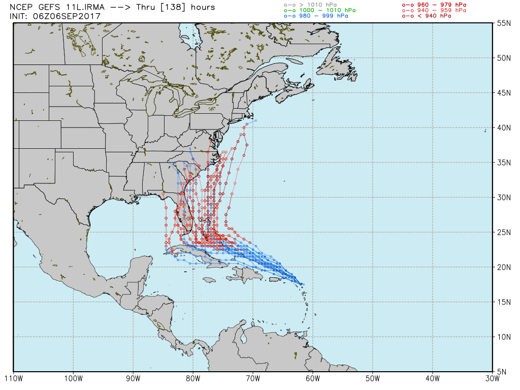
The European model ensembles (which last published at about 2am CT) haven’t shifted quite this far east, but it’s definitely moved back some.
As is often the case with weather and uncertainty, the best way to make a forecast is through probabilities. On Tuesday I presented three scenarios for Irma, and I want to revisit them this morning, now that there’s been an eastward shift in the guidance. By way of reminder, here’s the map I used for the three scenarios:
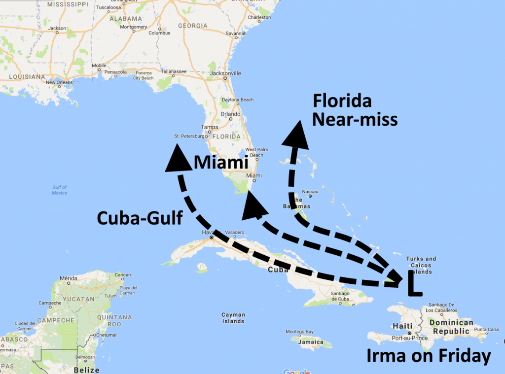
Cuba-Gulf (35 percent down to 20 percent)
The odds for this scenario have fallen due to the movement by the models. With pretty high confidence, we can now rule out a final landfall for Irma to the west of Pensacola, and more and more it looks like if the storm does move west all the way into the Gulf it will bend back toward Florida’s west coast, rather than traveling all the way up the Panhandle.
Miami (35 percent down to 30 percent)
This is the scenario currently favored by the National Hurricane Center’s official forecast shown above. And until the European model ensembles move substantially more to the east, I am not going to feel comfortable significantly lowering the odds of a strike on southern Florida too much.
Florida near miss (30 percent up to 50 percent)
Obviously the trend lines here are great for Florida, however there are some definite concerns with this scenario too. It’s destructive for the Bahamas, of course, and in the six-seven day range the track also may well curve back to the northwest and move into the Carolinas.
Tropical Storm Jose
This system is not a concern as of now. There’s an outside chance that Jose approaches the US East Coast in 7 to 10 days, but most likely it remains out at sea in the Atlantic Ocean as a “fish storm.”
Tropical Storm Katia
Katia is not a concern for the United States, as it will be confined to the southern Gulf by a cold front moving off the Texas coast. However it has a chance to become a hurricane, and is likely to bring some heavy rains to the central Mexican coast and inland areas, including Tampico.
We will update again on Irma this afternoon at around 3pm CT.
I live on Merritt Island Fla. and have friends on St. John (the Rocket Boy lives down their you know). Tropical Storm Jose is due to make it’s turn North at the northern Leeward Islands as a hurricane. This would be just as people their are digging out from under the rubble left by Irma.
Word from St Martin, Anguila/Barbuda is that those places have been flattened.
We got 0.8″ of rain at 2AM this morning and lost power for 3 hours. The sound of rain used to be soothing. Now my psychological reaction is the opposite, even though I knew that it would be a brief storm. Rain is a menace now.
For me, too.
Same… the thunder and lightning gave me a bit of a panic (I’m right near the evacuation line for Addicks and Barker
I see dark clouds and go into ptsd mode.
Eric, your evil plot is busted:
https://www.mediamatters.org/video/2017/09/05/limbaugh-says-irma-hurricane-warnings-are-scheme-benefit-retailers-media-and-climate-change-agenda/217842?utm_source=fark&utm_medium=website&utm_content=link&ICID=ref_fark
But seriously, how the hell can anyone look at what Harvey just did and then rant about weather forecasts like that?
Because Rush Limbaugh is an asshole.
Used to be that even assholes might err on the side of not having hurricane casualty counts in the hundreds or even thousands. But times have changed.
Is there any reason for this sort of comment to be at an otherwise intelligent, rational, cool-headed, science-based, clear-hearted/-minded blog? One of the precious few on the World Wide Web, to boot.
If I wanted this sort of self-absorbed political nattering there’s ten bazillion other places it can be gotten.
Moderator/hosts, please don’t let this sort of thing taint your blog, especially since most of it these days is not organic in origin, but mainstream media outlets trying to dilute the competition.
Please, PLEASE preserve the excellence of this amazing Wx blog by asking the clever and itchy to go elsewhere for their fix of kneejerk!
Leave him alone, Weather God Eric has previously mentioned that he is only covering this because readers have asked him too.
The premise of this site is “hype-free forecasts”, suggesting that hyped forecasts also exist, no?
Because clickbait-currency eyeball grabbers are in that line of emotive/propaganda work in part because they can’t do statistics and don’t understand probability or large-system modeling.
But they can say outrageous or provocative things. And they get many–most?–of their clicks from people who like to heave about disagreeing with them.
Just ignore them. Our hosts here have much better content on which to bestow our precious time and attention.
Limbaugh is truly unreal. I guess he hasn’t learned from history. The 1900 Galveston hurricane was not forecasted (Isaac did suspect a storm was coming but he really didn’t know exactly), at least not in the way that we can now, and 6000 people were killed! Many while trying to evacuate in the middle of the storm! We are weather enthusiasts, science people, or other interested parties and understand the need to be informed. Harvey surely shows us that! I often wonder, does Limbaugh actually believe the crap he says or is he just a personality and is really just putting on a show. I just have a hard time that someone could be that thick-headed to say something like he did in the above post!
The spike in gas prices will be due to Harvey, not Irma.
Eric, once again two of your worlds may be about to (literally) collide. I’m getting more and more nervous about the Cape, Irma’s track and the space infrastructure there…
It would be interesting to see some diagrams or illustrations on how hurricanes are effected by different fronts (cool fronts, warm fronts) and how our cool front effects the path of hurricane Irma. Perhaps this could be a future post?
Eric
Any idea on if the Ponce, PR will get a direct hit from Irma. It looks like the North Part of the Island is getting it. We have family members in Guanica, PR. right now
I would like to see a discussion of how flood plains are irrelevant and misleading. Tropical storms/hurricanes go wherever they want and dump massive amounts of rain where ever they please. People don’t buy flood insurance because they are in a good flood plain and then suffer enormously. We should encourage everyone who can to buy flood insurance.
You start.
How are they (flood plains) irrelevant and misleading?
Most folks don’t buy flood because they know the government will step in and provide relief anyways.
People look at the maps, think they live in an area not prone to flooding and decide not to buy flood insurance. Then some random storm passes overhead and they are flooded.
God is so great.