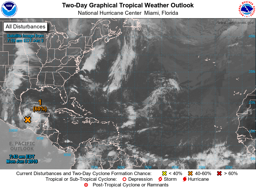
Houston’s hot weather—the region got its first real taste of the mid-90s this weekend—will continue for one more day before moisture begins streaming into the area from the south. From late Tuesday through Thursday, a tropical disturbance moving up the coast will bring a healthy chance of rain to the region. While some heavy rain is likely, we don’t have any major flood concerns at this time. The National Hurricane Center gives the system a 60 percent chance of becoming a tropical depression or storm, and the ceiling on intensity is almost certainly a low-end tropical storm. More on this below.
Monday
Conditions today will be a lot like Sunday, with partly to mostly sunny skies, and high temperatures in the low to mid-90s. Sunscreen, water, and repeat. Lows Monday night will only fall into the upper-70s.
Tuesday
Skies will turn partly cloudy as moisture begins to move into the area from the south. Rain chances should remain fairly low—20 to 30 percent —for most of the day before the tropical tropical disturbance begins pulling north toward the region. Timing is a bit tricky, but the heavier rain should hold off through the daytime hours on Tuesday. Highs will be around 90 degrees during the daytime.

Tuesday night through Thursday night
Between now and Tuesday night, the tropical disturbance should follow a track to the northwest, toward Brownsville. But by Tuesday night or Wednesday morning, it should follow a more northerly or northeasterly path, likely along the Texas coast, or just offshore. For Texas’ rain chances, offshore would be better because it means reduced rainfall amounts.
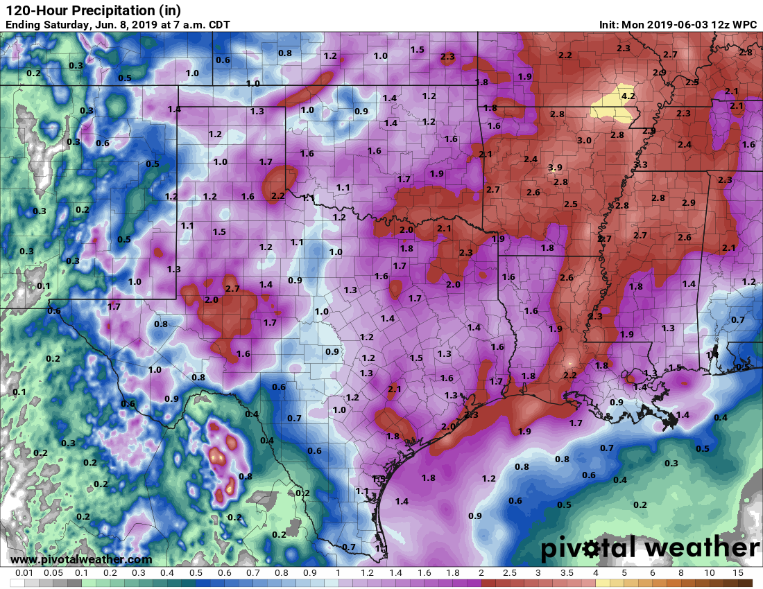
Beginning from Wednesday morning, rain chances will be higher in Houston, above 70 percent, and still higher on Thursday as the bulk of the disturbance moves near Houston. Tropical air masses are especially efficient at producing heavy rainfall, but again we’re hoping that the best conditions for heavy rain will set up offshore. If that happens, most of Houston should see 1 to 3 inches of rain through Thursday night, with potentially a few higher bullseyes of perhaps 5 inches of greater. If the tropical disturbance plows into Houston, rain totals will be greater, but for now we expect the former scenario. We’ll continue to watch this closely and apprise you of changes.
The other concern, for the coast, will be higher tides due to the onshore flow. Right now, it appears as though tides will be about 3 feet above normal levels, but again this is subject to change due to the storm’s movement and strength changes.
Friday through the weekend
Although the bulk of the moisture should move east of the region by Thursday night, we should see some lingering shower and thunderstorm chances on Friday, with highs in the low 90s.
At this point, most of the weekend looks sunny, with hot temperatures in the mid-90s—a lot like what we just experienced this past weekend.
Guys – I’ve been following you for years now. I’ve since moved from Houston to Beaumont, however what forecast is as nearly relevant. Needless to say, I sincerely appreciate you hard work and consistency.
Please keep up the great work!
High tides could be 3 FEET above normal? Is that a typo?
Assuming they are expecting a “surge” as the system approaches. Especially with 20 mph direct onshore winds for several days
Our tides in Rockport have been high since early May. The Spring winds feeding the storms in North Texas and beyond all month have kept us rocking down here. Another 3 feet and we’ll be over the bulkheads for sure!
We are flying out on Thursday. Do you anticipate issues with air travel?
Thanks Eric for the information! Really do appreciate all you do!
Thank you for the info! I always read your no hype/straight-forward analysis first because the news media will probably have a heyday with this! Many of us appreciate your “just the facts ma’am” style of weather reporting so much!!
I’m going to start boarding up my windows tonight and secure hotel reservations in Amarillo.
Hipefully, the storm won’t reach that far!
What about air travel on Wednesday?
Do you guys know if there’s anything like Space City Weather for the Orlando region?
There is a Tropical Met I use out of TPA. His name is Thomas “Storm” Walsh. He’s pretty good and keeps a close eye on Florida.
https://storms.wordpress.com/
https://stormw.wordpress.com/ gets you to Walsh’s current forecast page.
Mikes weather page on Facebook.
Time to head to Spec’s…
There ain’t no such thing as a free lunch!
Evacuate Fulgencio!
I really appreciate your drama-free weather forecasts. Thank you!
Great reliable source for the weather.
Thank you guys for keeping us up to date. Especially as hurricane season ramps up, we’re thankful for some sensible, accurate, and well-written updates like this one! Thanks again!