Good morning. Houston will remain in a very wet pattern through the weekend, highlighted by the arrival of moisture from a tropical disturbance—possibly a tropical storm by then—on Friday. This should lead to elevated rain chances through the weekend, especially for coastal areas. We’ll discuss this in greater detail below.
Wednesday
The radar is mostly quiet this morning, with the exception of northward moving storms near Baytown and Channelview. With tropical moisture pushing in from the coast, we expect more widespread storms to develop this afternoon. For the most part accumulations should be less than one-half inch but a few areas may see higher bullseyes—such is the nature of tropical rainfall. Skies should remain partly to mostly cloudy today, limiting highs to around 90 degrees, with light southeasterly winds. This evening and overnight hours should be mostly rain free, although we can’t rule out a few stray showers.
Thursday
We probably will see a brief reprieve from widespread showers on Thursday as some drier air mixes into the atmosphere. At the surface, conditions will still be plenty humid, however, and combined with partly sunny skies we should see daytime temperatures rise into the mid-90s. These afternoon highs, in turn, could trigger a few afternoon showers, but most of us should remain dry.

Friday, Saturday, and Sunday
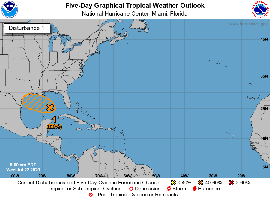
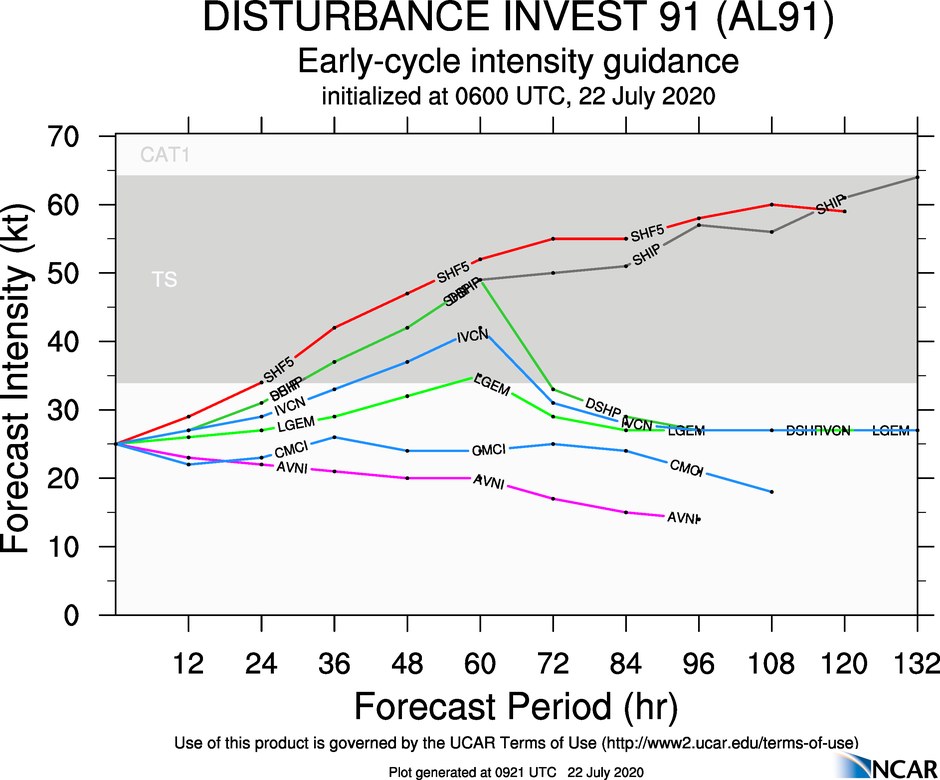
Our weekend weather will be determined by the evolution of a low pressure system, tagged as Invest 91L, presently in the eastern Gulf of Mexico. Although wind shear is fairly low, and seas are plenty warm, this system is at present disorganized and encountering some dry air. It has a little more than two days to get better organized to become a depression or tropical storm before making a likely landfall along the Texas coast on Friday night or Saturday. The National Hurricane Center predicts a 50 percent chance of this happening, and we think the odds of this are probably slightly better than 50-50.
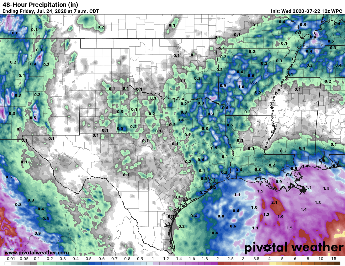
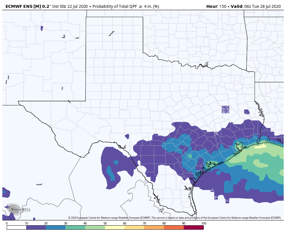
What does seem clear is that the greater Houston metro area will be on the right side of this system, and therefore subject to some of its heaviest rains. However, due to the westward progression of the system, and the aforementioned dry air, at present it does not have the look of a prodigious rainmaker. Right now we would forecast 2-4 inches of rain for most areas (with totals toward the higher end along the coast), with higher isolated amounts. With tropical moisture like this we always are concerned about high rainfall rates, which can back up streets quickly. We’ll be watching for this and updating as needed, but right now we envision a pretty wet weekend in Houston, rather than one with widespread flooding.
With mostly cloudy skies and rains, high temperatures throughout the weekend will struggle to reach 90 degrees.
Next week
After Sunday we should transition back to a more summer-like pattern, with highs in the low 90s and a chance of showers.
As I studied the first screenshot, I kept wondering whether the black Sharpie would be used to include Alabama. The black Sharpie is always very helpful for those last-minute forecast changes.
All kidding aside, I’m hoping the tropical ball o’moisture will keep moving westward at a good clip to give the Hill Country and West Texas a good recharge soaking. Keep those rivers and aquifers filled.
Nah, the black sharpie will be blue instead and headed to Mexico this time.
It is true though that with a rapidly approaching tropical disturbance that COVID-19 cases will dramatically decline and mostly become a thing of the past complete and total sarcasm The blue sharpie will accentuate this shift in cases.
In all seriousness bring on the rain and get this thing out of here!
I thought it meant less COVID because of less testing. Anyway, take your Clorox Chewables just to be safe.
Great idea! Can these be found on Amazon?
And say hello to TS Gonzalo!
As someone with a family all suffering from some PTSD from Harvey, we truly appreciate the straightforward information that you provide. This is a very stressful time of year for many, and it is refreshing to get the facts without the drama.
Would be Hanna Tim. The depression east of the Caribbean in all likelihood would be named first.
Yeah, I was alluding to the newly named TS in the MDR.
You are right; Gonzalo is born!
It’s called Gonzalo.
You think South Padre Island will stay dry? Was planning on a get away this weekend.
Nope
what is the stage level number expected for this event, or do y’all not use that scale anymore?
I hope Gonzalo dissipates…
uhh, the news stations are starting their fear mongering already – noting that we could have a “flood disaster” on our hands. Here we again……………