Today’s update will talk briefly about that Gulf disturbance coming to Texas this weekend, but more about what is behind that system as it appears the tropics are waking up, and they may not shut back down for a while.
Tropical outlook in a sentence
We expect a low-end system to form in the Gulf this week, another system will make an attempt to develop in the Atlantic, east of the Lesser Antilles, and with more waves emerging off Africa, more development will be possible heading into early August.
Gulf system
Eric has done a good job each morning discussing what we know and expect from the potential late week system in the Gulf. As of this afternoon, the system is a disorganized “blob” of thunderstorms over and around Cuba.
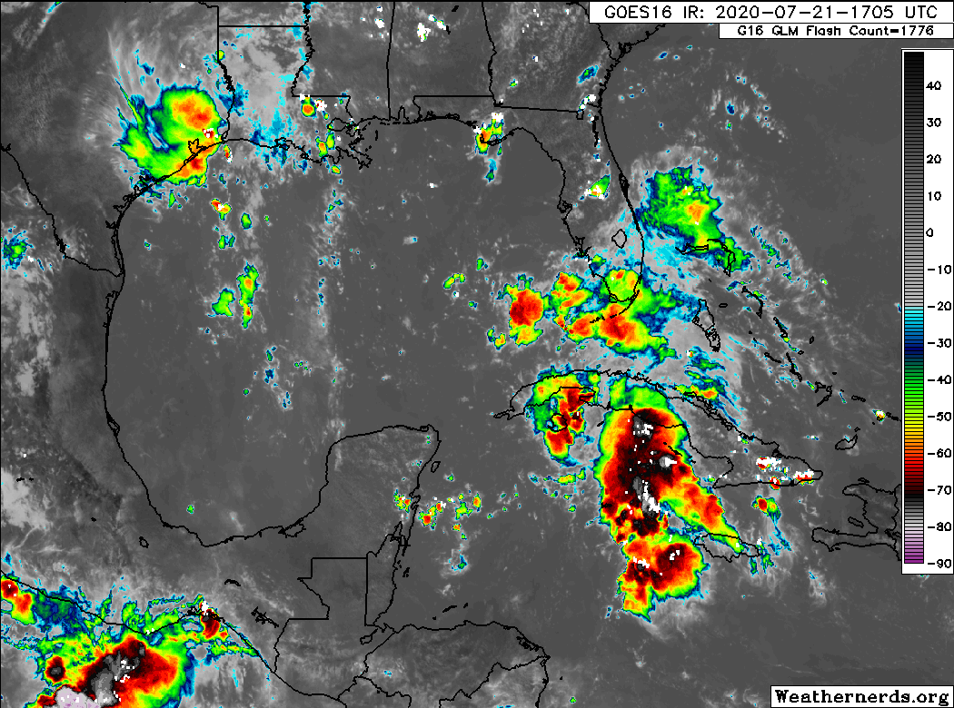
However, as that moves into the Gulf, it will find decreasing wind shear and fairly warm water to work with. It seems there are two things that will hinder this system’s development into anything worse than a depression or moderate tropical storm: 1.) It will enter the Gulf disorganized. And 2.) It will move at a steady clip, so it’s going to run out of time over water fairly quickly to develop. So the ceiling is constrained by time. Still, a strengthening tropical storm in the Gulf on approach to land is nothing to sneeze at or write off completely, so we’ll monitor this closely. Of note, the morning model data so far is not any further bullish on this system’s development prospects, and the National Hurricane Center maintains a 40 percent chance of development over the coming days. Regardless, we will see some locally heavy rainfall associated with this, be it as a disturbance or organized depression or storm. Thankfully, it is expected to keep moving at a steady pace. We will continue to monitor it for you, and Eric will have the latest in the morning.
Invest 99L
The NHC has given the disturbance classified as Invest 99L about a 90 percent chance of development out in the open Atlantic Ocean, just east of the Lesser Antilles.

This system is very, very close to being a tropical depression already (as of this writing at 1 PM Tuesday). Invest 99L is going to be interesting. It’s rather far south and small, which will help shield it from a rather significant plume of Saharan dust off to its northeast. It is moving into an area of warm water temperatures and pretty low wind shear. Theoretically, this is a good candidate for development over the next 3 to 4 days as it approaches the islands. The various intensity models are very split on what happens here. I wouldn’t take the ultra high-end ones literally, but you can clearly see two camps: One that keeps the system middling over the next few days and another that says this thing will strengthen as it approaches the islands.
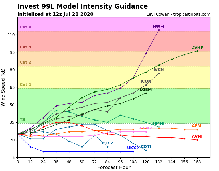
Which camp is right? Great question, and one we don’t have an answer to at this time. There are good meteorological cases to be made for both a lower-end system, as well as one that perhaps organizes faster than anticipated.
The track & intensity of Invest #99L likely to be closely linked over the next 3-5 days.
Forecast low-level steering is faster & zonal but deeper-layer steering (850-200-hPa) is slower & more poleward. If 99L becomes a vertically deep vortex early (<48h), large impact on future. pic.twitter.com/TIFABN0CWz
— Philippe Papin (@pppapin) July 21, 2020
Either way, interests in the eastern Caribbean should be monitoring the progress of Invest 99L closely. For us in Texas? It would be unlikely that this would survive the trip here. In fact, no storm within 150 nautical miles of where Invest 99L was centered this morning has ever made it to Texas, with the exception of Hurricane Allen in the Rio Grande Valley in 1980. So, if you’re playing odds, you’ll take those odds. We’ll continue to watch it however.
Of note, the next two names, which both could be utilized this week are Gonzalo and Hanna. The earliest “G” storm on record was Gert on July 24, 2005. The earliest “H” storm was 2005’s iteration of Harvey on August 3rd. Both records could fall.

Beyond 99L
Weather models are beginning to perk up with more hints of activity of varying degrees in the basin going into August. It seems we have turned a corner now, and it’s becoming more likely that we’re going to see activity kick up. Historically, during the next few weeks we would expect to see a ramping up of activity heading into mid-August. This is also in addition to very warm water in the Atlantic basin, which has warmed a good bit over the last week or two.
Below, National Hurricane Center forecaster Eric Blake shares a graphic showing waters in the Gulf, Caribbean Sea, and western Atlantic at temperatures well above normal:
Not exactly what you want to see as a property owner as we approach August… yikes. I don’t want any part of this upcoming season 👀 pic.twitter.com/OfFCWjxx8A
— Eric Blake 🌀 (@EricBlake12) July 21, 2020
On top of this, some of the signals we watch in the global tropics are beginning to hint that by mid-August, there could be additional background support to help systems along. The bottom line here is that it appears the heart of hurricane season is coming fast upon us, and we will likely be tracking various systems throughout the Atlantic basin pretty constantly from now until October.
Staying prepared
Even when skies are their darkest, Texans stand strong together. Reliant is ready for storm season 2020 and we can help you get ready, too. Plus, we’ll be with you – and all of our neighbors – before, during and long after whatever the weather may bring. Take the time now to protect your family, home and business, starting with Reliant’s Storm Preparedness Checklist.
Here are some other tips to prepare ahead of time:
- Be informed: Sign up for local alerts by county or city.
- Protect your property: Prepare your home by reviewing insurance policies, sealing windows and doors, and checking your storm shutters.
- Backup critical documents and information: Important files should be backed up digitally to prevent the loss of information.
- Plan for pets and animals: Have plans for your pet in case of extreme weather. You may not be able to take them to a public shelter with you, so you need to prepare for their care. More resources for pets can be found at reliantstormcenter.com.
- Plan for backup power: Stay powered and connected anytime, anywhere, with our range of at-home and portable power options.
- Plan for evacuation: Sit down and review every step of the evacuation plan so that if the time comes, your family is ready to act.
Hello Eric and everyone on staff! Thank you for your no nonsense daily weather reports.
My husband and I are full time RV’ers and are currently residing in a 5th wheel travel trailer in an RV resort in Galveston. Do we need to seriously consider packing up and moving out for the weekend due to the probable Tropical Storm? It takes a couple days to pack up this bad boy so I’d love to have your thoughts. Thank you.
Ooh, that Allen. It’s never mentioned much since it eventually calmed down a good bit and then entered Texas at fairly open S. Texas ranch area. But for a time there – in what had been an obscenely hot August, 1980 – it had ALL our eyes glued to it – a near Cat 5 heading close to landfall in SE TX and a satellite shot where it took up literally the ENTIRE Gulf of Mexico!! Have that front page somewhere and need to find..
As always, a lot less jittery about the return of these systems knowing we have you and Matt to keep us informed. We are forever grateful.
Edit: you and ERIC. 😉
So…..you are basically saying that Invest 99L is going to turn into a monster hurricane and destroy the Gulf coast……2020 is not a normal year. Any other year, saying the odds are very low, I would take comfort in. But this year, is not any other yeat.
Too soon to ask about Douglas? On NOAA’s Eastern North Pacific 5 day, he looks like trouble.