Good morning. Tropical Storm Nicholas has a better defined center of circulation this morning, and it has reformed north of where forecasters believed it to be earlier. This, combined with an expectation that Nicholas will now move a little bit more quickly once inland, have led to some changes in timing and rainfall amounts in the forecast. As a reminder, we’re continuing to predict Stage 3 flood conditions for some parts of the greater Houston area through Wednesday. Some, but not all, of our region will see prolonged heavy rainfall beginning later tonight.
Storm status
Tropical Storm Nicholas has strengthened to have maximum sustained winds of 60 mph this morning, as of 4am CT, and is moving to the north-northwest. The storm will likely make landfall this evening between Corpus Christi and Matagorda Bay.
This will bring tropical storm force winds to the Matagorda Bay region on Monday afternoon, and these could spread up the coast to Galveston Island on Monday evening. Tropical storm force wind gusts will spread inland into portions of Harris, Fort Bend, and Colorado Counties late Monday or early Tuesday before beginning to weaken during the afternoon hours. These winds should not be great enough to produce widespread power outages in the Houston metro area, but some local problems are definitely possible.
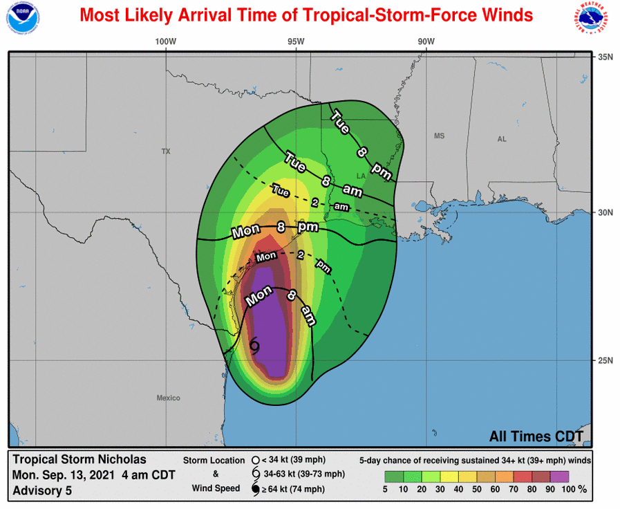
Storm surge values of 3 to 5 feet are possible from Port O’Connor to Sargent, and 2 to 4 feet from Sargent to Galveston to High Island. Some significant inundation is possible around Matagorda Bay.
For nearly all of us in the greater Houston metro area the biggest concern, by far, will be rainfall.
How wet will it get, and when?
The Houston region should see scattered to numerous showers on Monday, but the heavier rainfall that is most concerning to us should fall between a 36-hour period from Monday evening into Tuesday night, or Wednesday morning. So this is the time when you should plan for the most significant impacts.
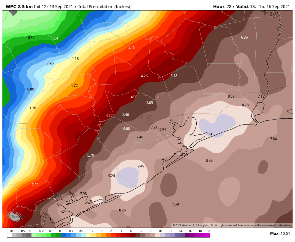
The flood threat is very real, but it is slightly mitigated by the fact that Nicholas is now expected to continue moving to the northeast after it reaches Houston, and seems less likely to slow down. This should, hopefully, bring down rain totals somewhat. To that end, the map below represents an average expectation of the rainfall your location will get from Nicholas. For much of our region, these should be mostly manageable totals.
However, it is important to note that we are most concerned about locally higher amounts, which are likely during a tropical system that produces training thunderstorms with extremely high rainfall rates. Therefore, some locations may see as much as 10 to 20 inches of rainfall from Monday evening through Wednesday morning. While these bullseyes are more likely near the coast, they are definitely possible as far inland as Harris, Montgomery, or Waller counties.
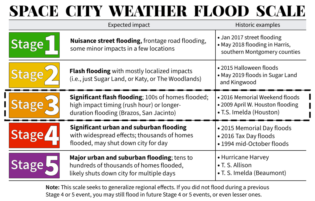
Please note that we have issued a Stage 3 flood alert, on the Space City Weather scale, in expectation of these bullseyes.
Conclusions
Nicholas will soon be here. While conditions across the region should be OK for much of today, they may deteriorate fairly quickly this evening or after midnight. In our next post we will try to provide a firmer time for the onset of heavier rain in the metro area—whether that’s 8 pm, midnight, or later. Our next post will come no later than 10:30 am CT.
Pulled up Zillow for the Denver area and am wistfully scrolling around. I’ve been in Houston for all 43 of my years on this earth, but dear God in heaven, this is getting exhausting.
Denver gets tropical storm like winter storms most winters now.
I don’t mind the winter storms—a winter storm that drops six feet of snow isn’t likely to flood my home and destroy everything I own. It’s the whole “wake up one September day and find that you’re 48 hours away from a massive flood event and there’s nothing to do but hope your flood insurance is paid up” part that I’m sick of.
Seconded.
Denver is nice! The only thing to worry about there is blizzards in the winter, wildfires in the summer months, and rock/mud slides. Also, in more rural areas around Denver – mountain lions and bear! My sister left Houston 4 years ago b/c of the rise in crime (much worse these days). They relocated in Durango, CO and never looked back.
Well, Durango is as cool as it gets. I wouldn’t leave either. I wouldn’t want to live in Houston and my name is Houston.
I have friends in Denver who can barely breathe in the summer and fall because of wildfire smoke, so there’s that, too.
That’s am awful thought.
How about having to leave your home cause of a fire like we just did in Tahoe . And so much smoke for a month. I’ll take a hurricane over a forest fire anyday
I’d say the biggest difference is that we could at least do something to manage fires, but it’s as if a political and cultural challenge (what I believe is truly making the fires as bad as they are) is just as difficult to overcome as a force of nature like a hurricane (which we can do little about except to mitigate the effects).
Exactly…or your roof is blown off
And summer wildfires as well…
Agreed! 25 years in Houston. We lived in Denver for three blissful years with a couple of major snow events. Never thought about evacuating or losing power. We’ve been back a few years and have been through too many foods, storms, and near-misses to count.
Hmmm, maybe you were lucky that you never lost power during a snow storm. In my 30 years in several areas of the I-25 corridor from Trinidad up to Denver, we lost power a few times during blizzards or just bad, heavy snow storms. And when you don’t have a fireplace it get pretty darn chilly. But the house never flooded from a T.S. or hurricane.
Imagine what the folks in Louisiana experience if you’re exhausted…
That’s my thought too, those poor folk have had it really rough!!!
So true. The last couple of year nature disaster have been a major things for them. Unfortunately
My family and I just moved to Champaign, Ill this June. Our home didn’t flood during Harvey, got water halfway up the driveway during Imelda, then got water to the garage in an afternoon from thunderstorms.
I am really enjoying cool evenings and anticipating fall. But I worry about friends and family, so not all of the anxiety has left.
I’m from that part of the country. This is how I would describe driving down the street not too far from where we lived after a tornado came through about forty or fifty years ago:
House, house, house, house with the trees looking kinda ragged, no house anymore, no house anymore, no house anymore, house with trees looking kinda ragged, house, house, house, etc.
Hanging out in the basement while hoping you don’t have to run buckets of water upstairs because your generator failed and now your sump pump isn’t running is no idea of a good time.
Plus, you’re living in East Central Illinois.
Good Lucy…..I hope you like shoveling SNOW…..
I’ve been paying someone to mow my lawn for 20 years, so I’ll have no problem paying someone to shovel snow for me, too 😀
How do I read the map to know exactly where we are? I can’t see la snarks or anything!!
Thank y’all for all that you do to keep us weather aware. It is greatly appreciated!
New to Houston and this site was recommended by several people! Thank you! I’m wondering how storms like this typically affect flights. I’m up in Tomball, and a little nervous about driving family to the airport Tuesday evening.
I think the biggest issue would be driving there. Tends to flood in Tomball and spring a lot in certain areas. If you can stay on 99 and Hardy toll roads you may be fine getting there. Good luck!!
Flights Tuesday will probably be canceled. Southwest already has a Travel Advisory in place.
Where do I see such advisories?
Your airline’s website should have the advisory. If you have the airline’s smartphone app and are logged in, you should see any advisories that pertain to your flight.
The FAA also has a website that shows airport delays.
FM 2920 in Tomball always floods about 1/2 mile west of the highway 249 tollway, near Calvert rd. Parts of the Grand Parkway (hwy 99) have flooded but it takes a ton of rain to do that; more worrisome are the feeder roads.
Thank you for your detailed work and what to expect. Looking at prior comments there’s nowhere on this planet you will overcome climate change. It’s definitely everywhere. I am grateful we have improvements from Hurricane Carla days on forecasting. Been through all the hurricanes and tropical storms since the 60’s and thankful we are prepared better now!
Good morning
I like to thank you ALL for the notification. Y ou are always correct and on point.
I truly appreciate you.
Stay safe
Karin Salameh
According to latest weather channel, storm will stall for a couple days over Houston, surrounding area.
You mention the storm will speed up, they say it will slow down. Obviously a massive difference as the slow down would mean massive flooding vs some flooding with a faster-moving storm. The question is, who is right?
the local networks are said it will speed up but ultimately I go with this site/app. I don’t listen to the national networks anymore. They lost me when they have a reporter deep water sitting in a canoe acting like it’s 4ft deep while in background dudes are walking around in ankle deep water with no issues. Or when the lean-in against the wind when guys in background just standing normal. It’s all BS they are just looking for the perfect shot. I put my trust in this site, at least if they get it wrong (hardly ever) they own up to it.
When they get it wrong, which is rare, so does everyone else! After being the only weather experts to be spot on ab Harvey (when my son and family lost everything) I’m a loyal SCWfan! Thank you for keeping us informed and for your excellent coverage..
Who gets more money from viewers glued to their screens watching for disaster?
The Weather Channel is all about ratings, listen to the locals.
Been watching the weather channel all morning and they have never mentioned stall. Keep saying it slowed down in open water, but expect it to move out quickly. They seem to align with everything Eric has said.
@eric or @matt, thanks for the always helpful and relevant updates. If you could add any commentary/input on your next about for those flying out of Houston over next couple days? You’ve been known to do that, and it’s always helpful. Thanks!
And those of us flying into HOU or at least trying to
It’s not quite the same since we’re in a small general aviation aircraft instead of a big airliner, but I’ve had to cancel my flight lessons up in Conroe mostly because we won’t be able to fly under Visual Flight Rules (VFR). Just speculating on how the storm is likely to track, I’d guess that you’ll have more luck flying into/out of IAH than Hobby just because it’s further north. The winds don’t look too bad, which would be the primary concern for flights. Of course, if the road is flooded on the way to the airport itself then it’s a moot point.
The news media is always worse case scenario. It could happen but. The great thing about SCW is you get a range of possibilities that update regularly and things develop and become better defined.
Any prediction how much rain Galveston Island will see? Thank you for all the information you give us. You are my go to guys for weather conditions. Especially when I can’t be there to prepare.
If you could overlay cities on the rainfall map like you did yesterday, that would be extremely helpful.
Yes that would be most helpful!!
Is it time to enable the ‘Evacuate Katy’ button on the app?
Thank you for all your hard work, especially in times when we need you guys the most!
I’m supposed to fly into Hobby from Kansas City, MO on Wednesday morning. My daughter who lives in Katy is supposed to pick me up! Yikes! Should I hang out at the airport for a few hours or more so she doesn’t have to drive in this storm! Or…maybe I won’t even be landing at Hobby??? I’m trying to keep a close eye on Nicholas!
Hearing a few reports of a double eye on this hurricane. Does it change the forecast?
Any updates on possible flood timing? I am scheduled to work in Baytown till 7pm which isn’t looking like a good plan but I really can not tell.
Looking at the forecast on WU later this week and it’s still showing rain. I thought usually after a tropical system moved through it was dry on the backside for at least a few days?
A message from the League City’s city manager lists 3 reputable sources for following the approaching storm. It was nice to see you recognized, especially with the other 2 being federal agencies. Well done!!
Welp, here we go again, folks. Stay safe everyone.