This post will attempt to set expectations for the timing of Nicholas’ rains and winds later today, tonight, and on Tuesday for the greater Houston metro area. Given that there remain some questions about the storm’s precise track and movement speed, these remain estimates, rather than set-in-stone predictions. But we recognize that this information is important for planning purposes, and so we’re giving it our best shot. Thank you for understanding that this is an, uhhh, fluid situation.
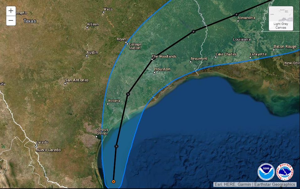
The center of Nicholas has been wobbling somewhat this morning, but the National Hurricane Center says the storm is still moving generally northward, and should approach the Texas coast this evening near Matagorda Bay. The storm retains 60 mph winds, and is being hampered by a bit of dry air and wind shear. However, this shear may relax enough to allow Nicholas to strengthen into a Category 1 hurricane before landfall. It will be close. The storm then should move almost directly overhead the Houston area on Tuesday. This post discusses what to expect from this track.
Monday day time
So far, as expected, showers and thunderstorms have been manageable today due to their fairly rapid motion. We should continue to see fast-moving showers traveling from the southeast to northwest throughout the daytime hours. Some of these could be briefly severe, but we don’t anticipate any significant flooding. Winds may also pick up this afternoon, but are unlikely to gust above 30 mph from the east-southeast.
Monday night and Tuesday morning
Based upon our latest data, the period of greatest impact now seems likely to occur between sunset on Monday and about noon on Tuesday. If you want to be perfectly safe, the best plan is to remain off the roads in the Houston area from around 6 pm CT Monday through the middle of Tuesday. However, we realize that this may not be possible for everyone.
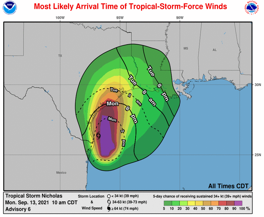
In terms of winds, we expect things to start getting breezy by around 10 pm to midnight, particularly along Galveston Island, where gusts may briefly reach hurricane strength. In Harris County, sustained winds may reach 30 to 40 mph, with gusts in the 50s to 60s, especially by midnight or shortly after. This may well lead to some power outages, especially south and west of Houston. I inquired to CenterPoint about their expectations for power losses tonight, but have not heard back. Past experience with such winds suggests there will be isolated to scattered outages due to debris and tree branches that get blown into lines. A storm surge of 2 to 4 feet is likely along the upper Texas coast.
With regard to rainfall, the heaviest storms associated with the core of Nicholas are likely to approach the southern part of the region, including areas such as Lake Jackson, by around 9 pm. The storms should then move near the central part of the metro area, including the I-10 and I-45 south corridors, around midnight or shortly thereafter. As the core of Nicholas moves near the area, the rains should be just ahead of it, possibly exiting Houston by Tuesday morning, or around Noon.
How much rain is going to fall?
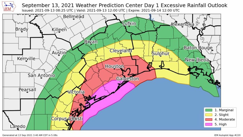
This, as ever, is the difficult question. Our highest resolution models continue to indicate the possibility of very intense rainfall rates of 3 to 5 inches per hour, which will quickly back up streets and bayous. It is not advisable to be out and about when these kinds of storms hit—especially because it will be dark, and driving in these conditions is dangerous.
The good news is that it still appears as though Nicholas will keep moving as it tracks through Houston on Tuesday, and away from the region on Tuesday night. This should help to limit overall rainfall totals for most to 5 to 15 inches of rainfall, with a few isolated areas seeing 15 inches or more. Rains totals will be greatest for coastal counties and the next inland tier, which includes Harris and Fort Bend counties.
What about air travel? Schools? The Harry Styles concert?
We’d love to be able to give you concrete answers on these questions, but we don’t have them. I think airline flights from after about 6 pm today through Noon on Tuesday are a big question mark, and I’d probably at least expect some delays.
Area schools should be closed on Tuesday, period.
As for Harry Styles, man, I don’t know. My daughter has been waiting months for this concert and right now there’s a chance the really heavy rains will hold off until after the show is over. But there’s also a reasonable chance its cats and dogs as the show is letting out of the Toyota Center. If they don’t cancel the concert, I’ll hope to be able to provide some better guidance later this afternoon. The safe thing is not to go, of course.
Our next post will come by 2 pm CT.
Get our latest updates, immediately
As a reminder, to receive instant notifications of our new posts, you can download our free app on Android and Apple devices.
Same here for HS concert with daughter. Hoping it’s refunded or moved again, because I don’t think it’s worth the risk as of now.
Same here for HS concert with myself. It better not be cancelled. I’ll swim there if it comes down to it.
Thanks for all the great work!
HS concert – canceled
Heehee on the Harry styles 😂 i wish her the best!
Thanknyou for saying more specific counties. We live in Brazoria and this will be our first major rain event in a new home 🙏
Thank you for your diligent, honest, and measured reporting – and the freedom from the media hype is especially acknowledged. Ever since we discovered SCW during Harvey, you’re our #1 source for H-town weather. We really appreciate you!
I’ll second that. Trustworthy, dependable information.
I discovered them during Harvey too and rely on them alone for the most accurate reporting..I never go to main steam media for anything.. I’m very thankful.for SCW!!!
The expected rainfall is reminding me of Imelda in ways I don’t like. Our house flooded in Imelda, and I think it’s safe to say we have flood PTSD. Fingers crossed for less rain.
According to the SCW flood scale, Imelda was Stage 5 and this one is graded as a Stage 3. As they say, this is only estimates and could turn out worse…but if you trust SCW then you should expect much less of an event with this compared to Imelda. This thing is still gonna suck though! Hope you guys do okay!
Imelda was a stage 3. It’s noted on their scale in the stage 3 examples – https://spacecityweather.com/the-space-city-weather-flood-scale/
It depends where you were for Imelda. In Beaumont it was SCW Stage 5 but in Houston it was SCW Stage 3 where Nicholas currently sits. Hope for the best but plan for the worst is always the best strategy. Stay safe everybody!
At 7am Houston was outside of the Cone, but at 10 nearly in the middle, just one day out. Isn’t this vey unusual? Seems like a major miss in the 7am forecast, “Possible center locations” of the storm shouldn’t change that much in 3 hours on day out, should they? https://www.nhc.noaa.gov/archive/2021/NICHOLAS_graphics.php?product=3day_cone_no_line
The storm is wobbling quite a bit and slowing down this morning. Very small changes now result in larger changes 24+ hours from now.
The center of the storm is messed up. What is up with Nicholas? it looks like there is another new center reforming east of the old one, which would shift the track even farther east! Or would it? Do the forecasters know anything? Can they?
I thought the wind shear was supposed to be weak at this time, but it still appears to be preventing thunderstorms from wrapping around the center, causing this confusion.
They forecast with the best information they have. Storms are unpredictable. Gotta go with the flow to some extent. SCW is the best around – – trustworthy and dependable and no scaring you half way to a heart attack.
Actually the storm’s center has ‘relocated’ a bit to the east. It sometimes happens when tropical systems are trying to get organized and Mid Level Circulation has to stack over Low Level Circulation.
All news reporting should follow your fine exampkr
Hope you hear this a lot—THANK YOU! I know I can always check your report and from that, make the right plans for my family…not the fearful, anxious plans I make based on the news. So grateful Houston has you!
Thank you for addressing Harry Styles concert status!
Same on Harry Styles! Want my daughter headed back to Arlington now and not attend the concert!
Really lean on your great no drama straight shooting reporting. Any chance you might consider adding Fayette, Bastrop and Travis counties too? You’ve got avid fans here in Austin!!
After Harvey, this will be a piece of cake. Right? And hey, Harry was good in Dunkirk.
You did not mention storm surge. I live in Dickinson and got 29 inches water in Harvey. With storm surge, coupled with the rains, will this potentially be as bad?
They did mention 2-4 foot on the upper coast.
Thanks so much for these posts. They are helpful!
Can you guys give an idea of the League City/Friendswood areas? The Weather Channel just said League City is at “high risk” of flooding. What’s your take on that? (So we can better prepare)
Again, thanks for your diligence.
Could you help us understand the difference in your time forecasting vs Houston news sources like KHOU? There seems to be a 12 hour discrepancy of when this thing is getting here tomorrow.
We spent the weekend at a beachfront house in West Galveston. The wind and the rain most of Sunday night were scary. I kept opening up SCW updates for reassurances! We checked out this morning with little to no wind and occasional light rain. Thanks for your no-hype, no nonsense updates.
As always THANK YOU for your clear, level-headed honest, hype-free weather updates. I always go to you first for my weather info! Harry Styles is cool and all but I can safely watch him on YouTube hunkered down with some venison chile tonight! Stay safe H-town❤️
I can’t recommended this page and your information enough. Great update and eager to continue getting information as you are able to share it or share your best educated guess. Thanks for the update.
Simply put: I am a fan of Space City Weather and all that you do. I recommend it every chance I get, even to strangers at “The Costco” who could benefit from some drama free meteorology. Thank you SO much for recognizing the need for facts only meteorology forecasting and reporting. It’s a breath of fresh, if not humid, air.
I adore your candor and calm when presenting the forecast. Thank you for ALL you do!
Nice work !! Always appreciated !!
Stay safe Houston and my prayers will be with you all and let not let anyone are the enemy in but as mother nature takes its curse God shall to Aman god is good.