By now most readers have heard about the tropical low pressure system in the Caribbean Sea, which is approaching Puerto Rico. It is not a tropical storm yet, as a reconnaissance aircraft on Wednesday failed to find a well-defined circulation. It nonetheless appears to be developing stronger thunderstorms, and is producing tropical storm-force winds. It likely will become a depression and then a storm later this week as it passes near the Bahamas and then tracks toward Florida.
The purpose of this post is to discuss what may happen after that, but before doing so, I want to discuss the fallibility of forecast models at this time, and why we don’t have that much confidence in where the system, Invest 99L for now, will go in five to seven days, if it does head toward the Gulf of Mexico.
Model inaccuracy—it’s considerable
Let’s focus on track models. They tell us where a storm will go. Although models can do a fairly good job simulating the large scale steering currents that guide storm motion, such as upper-level pressure systems, these forecasts remain sketchy when a tropical system is poorly defined. And as I noted earlier, Invest 99L has yet to develop a center of circulation.
With that said let’s look at track errors for National Hurricane Center forecasts for three classes of storms: hurricanes (which have well defined circulations), strong tropical storms (likewise) and depressions and weak tropical storms (not so much). Actually, the category we’re interested in isn’t even on this chart—”stuff that ain’t formed yet.” Thus at five days we can expect the track error to be at a very minimum of 350 nautical miles for undeveloped tropical systems, and likely much, much more.
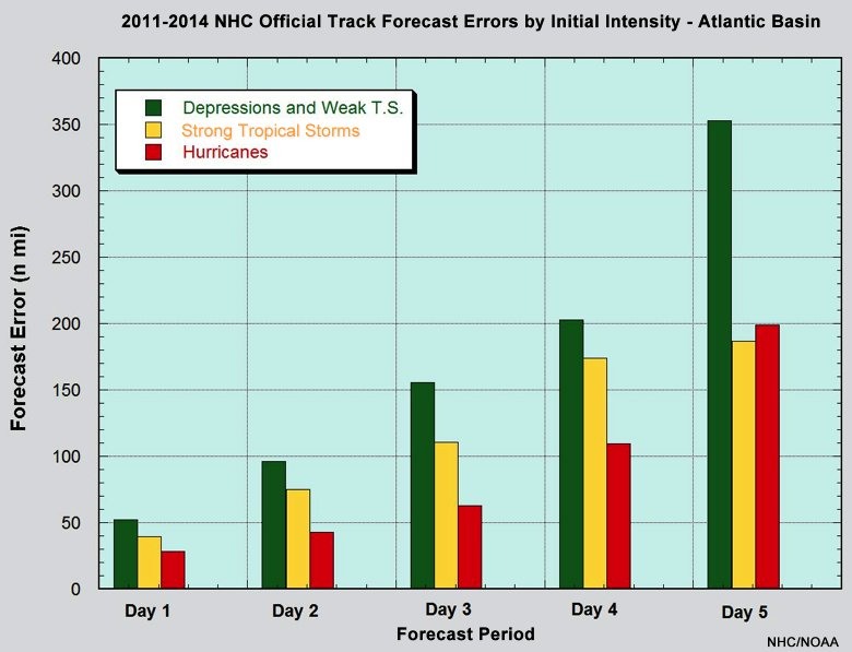
Moreover, the chart doesn’t even go to day six or seven (because the hurricane center doesn’t produce forecasts at such a distance). However if it did, the trend line is pretty clear, days six and seven would have greater error still. In short, the track error on any model forecast you may see for where Invest 99L ultimately goes next week is likely to be hundreds, if not thousands, of miles off. The track forecasts will get better after the system gets a well defined center of circulation, and when we get closer to an ultimate landfall. But we’re probably a couple of days away from that.
Track forecast
With that said, here are a bunch of track models!
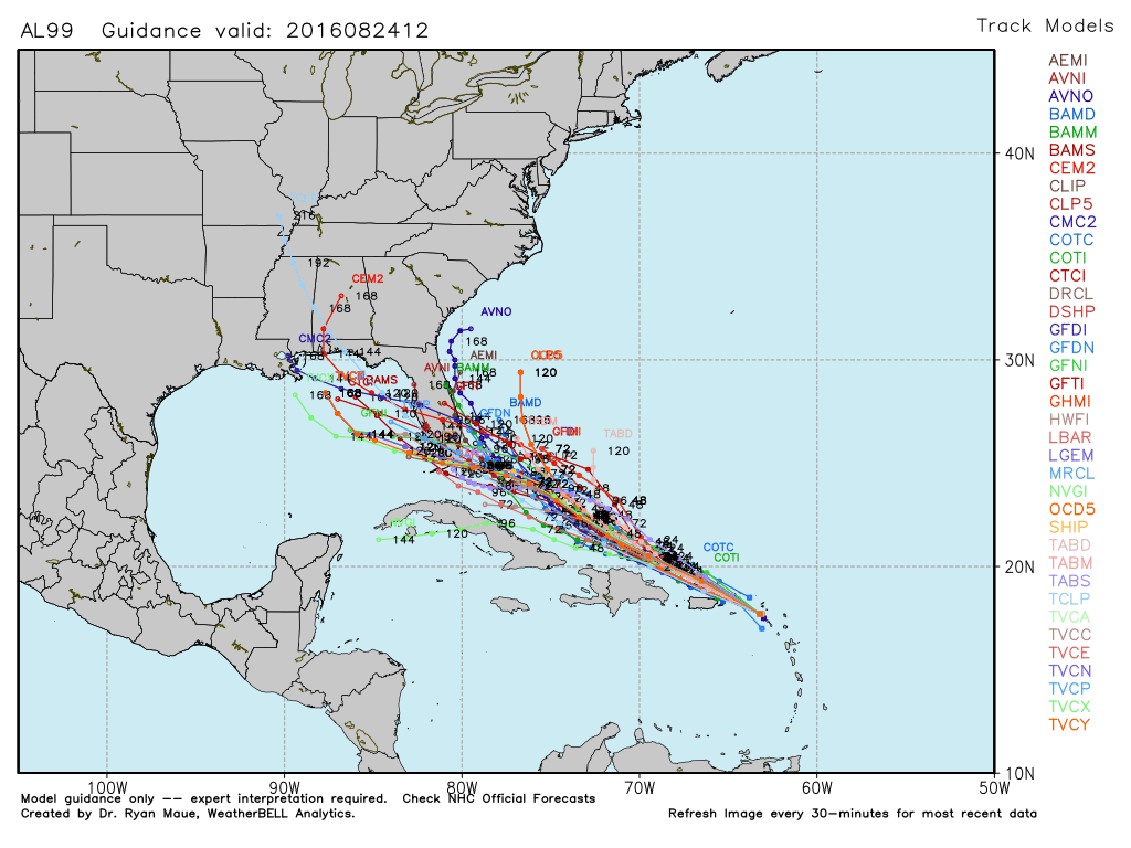
As you can see there is generally pretty good agreement about the system tracking toward Florida by this weekend, but after that there’s a split in whether the system will curve back into the Atlantic Ocean, or follow a more westward track into the eastern Gulf of Mexico. The critical forecast question concerns the position and strength of a ridge of high pressure over the Southeastern-Eastern United States. A weaker, more northern ridge would allow the storm to make a northerly turn before coming all the way into the Gulf of Mexico.
I’d still say areas from Texas to the US East Coast should be cognizant of this system, but I continue to believe the chances of this system getting all the way into the western Gulf of Mexico are fairly low.
Intensity of 99L?
The other key question is how strong 99L might get. The forecast models aren’t overly bullish on it strengthening, but lets face it, intensity forecast models are not particularly great. As 99L gets closer to the Bahamas I think wind shear will relax a bit, and there is ample warm water and oceanic heat content for this system to intensify fairly quickly. I’m not saying it becomes a hurricane before reaching Florida, but I wouldn’t bet against that possibility.
Wrap-up
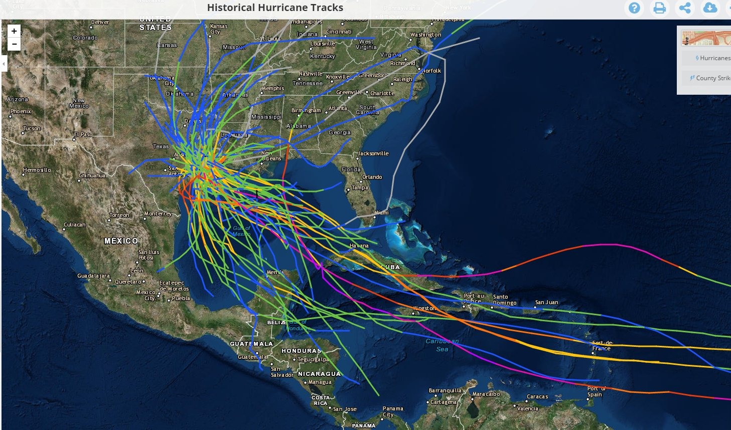
If all you’re concerned about is whether this storm affects Texas, I’d say that remains less likely to happen than other scenarios, especially in light of some of this afternoon’s forecast models. Additionally, historically, hurricanes that strike the Houston region tend to pass through the Caribbean Sea more to the south of where Invest 99L is (see this map of strikes put together by Matt).
With that said we’ll need to watch the development of this system over the next couple of days, and you can be sure we’ll do so for you.
Posted at 2:15pm CT on Wednesday by Eric
What would be the timetable for worst case scenario this storm develops into a hurricane and hits Houston? Going out of town next week for a few days and I’m wondering if I should have a plan for someone to watch my place.
On the very slight chance that this does affect Houston, I would say no earlier than one week from today.
1. Did Rita and Ike, two storms that affected Houston in a big way, form to the south of where 99L is now?
2. Are you saying there would be more reason to worry if 99L were organizing into a tropical depression near, or south of, Hispaniola?
Glad you are keeping an eye on it! My daughter is marrying OUTSIDE (with a Plan B!) in New Orleans on Sept. 10. Will this system be “done” by then?
One way or another — yes. Hope all goes well with the wedding!
Great post – keep up the good work.
Thanks for the update. BTW, good illustration of how forecast errors increase with horizon. Nice.
Perhaps an explanation as to the difference between location of the center of the storms and the location (extent) of rain and wind bands with respect to that center would be beneficial. I suspect a great many readers would appreciazte the explanation of the difference of area of impact.
Thanks Eric for your good analysis as always.
Is the magic date this year September 24th?
Thanks Again
Monty
Always.
The thought of a hurricane potentially entering the Gulf on 8/29, the 11th anniversary of Katrina, is unnerving. This new system’s timing and possible track (or at least “cone of uncertainty”) feel eerily similar to that monster storm and I’m reminded that four days before Katrina made landfall near the Louisiana-Mississippi border, it was but a 40-mph tropical storm at the tip of Florida and thought likely by many forecasters to go up the East coast of The Sunshine State. Don’t turn your back this weekend, Gulf Coast friends!
Thank you again, Eric. The voice of reason. I am terribly afraid of hurricanes and hate this time of the year.
For anyone interested…arguably the best data nerds on the planet tackle Invest 99L:
http://fivethirtyeight.com/features/hurricane-hermine-doesnt-exist-yet-but-experts-are-starting-to-worry/
Eric, Matt, Braniff,
Curious about your thoughts on their article given you’re in the meteorological trenches and this is coming from a very data-centric site?
The article is fine, IMO. I like Eric Holthaus, but he’s more of a climate writer than a forecaster.
Dear Eric:
The 12Z model run puts 99L as a developed storm over the Florida panhandle again, back where it’s been all along. Have you seen that?
I don’t know what got into the Euro last night.
Why does no one specifically show the jet stream. It is the most driving force that there is the Hurricanes, and yet it is not depicted in the maps.