A solid round of showers and thunderstorms rolled through Houston on Monday during the daytime, dropping 0.5 to 2.0 inches of rain for most of the area. It now seems likely that the radar will quiet down for most of this evening, before heavier showers being to develop along the coast on Tuesday morning like on Monday morning. The National Weather Service has prudently kept a Flash Flood Watch in place for coastal counties, and the inland tier including Harris County, through noon Tuesday (Note: after this post was published Monday afternoon, the flood watch was extended until 6pm CT Tuesday. Our forecast remains unchanged.) The best hope is that the heaviest precipitation stays just offshore, rather than migrating on shore during the next 24 hours or so.

Unfortunately, rain chances are not going to go away on Wednesday and Thursday. Although rain showers should be more scattered in nature, and perhaps less intense, we definitely can’t rule out locally heavy rainfall due to the tropical air mass and overall stagnant pattern. Given all of this, we expect accumulations of 1 to 3 inches for inland areas from now through Thursday, with 2 to 5 inches more likely for areas immediately along the coast (with higher isolated totals). The primary threat should be street flooding rather than significant stream and bayou flooding.

Invest 95L
The area of low pressure in the northwestern Caribbean Sea, moving toward the Gulf of Mexico, has been designated Invest 95L, which essentially means it is an area of interest. As of Monday afternoon, the National Hurricane Center believes the system has a 50 percent chance of becoming a tropical depression or storm during the next five days. The evolution of this system will determine Houston’s weather for Friday and the weekend.
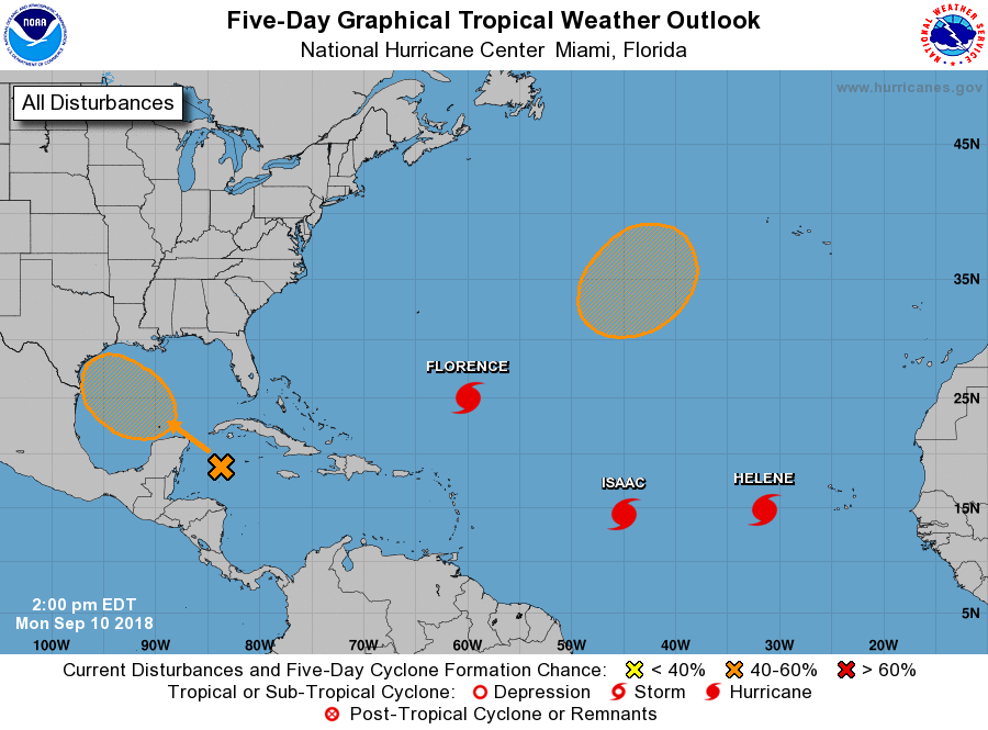
As of now, the forecast models are still split on whether the storm will develop. While it is early September and Gulf waters are warm, a fair amount of wind shear will remain in the Gulf of Mexico this week. This should help to limit the potential for this system to become more than a tropical storm—if that. All the same, we’ll continue to follow this closely as no one wants to see low pressure systems in the Gulf in August or September.
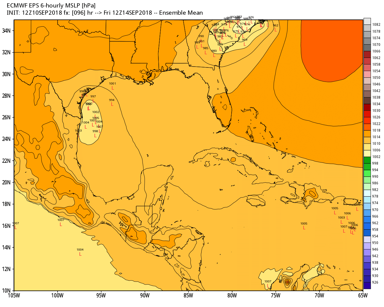
As for track, the European model ensembles have shifted somewhat south, away from the upper Texas coast. This is reflected in a plot of “low pressure centers” by the model for Friday morning. Note the cluster of “L’s” around the Texas-Mexico border.
All of the usual caveats apply here, but overall this storm does not present a well defined threat to the greater Houston area right now. We may see some increased rain chances again this weekend, but then again we may not depending upon where the system goes. We probably will have some better answers on all of this tomorrow, when Matt will be on hand to provide updates. As we said this morning, don’t be overly worried at this point, but please do be weather aware.
Hurricane Isaac
Several people have asked about Hurricane Isaac, a storm that is moving westward across the Atlantic Ocean and tracking toward the Caribbean Sea. For a lot of reasons, this storm seems unlikely to threaten the western Gulf of Mexico—it may weaken, it may turn north, it may just plow into Central America.
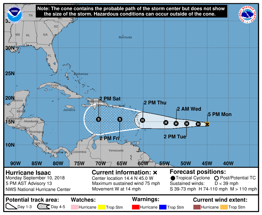
Because of this, we don’t think it’s worth spending too much time writing or worrying about Isaac in regard to Texas. That may change down the road, but for now the immediate forecast should be our concern, not low probability what-ifs.
Sponsor note
Just wanted to take a moment to thank Reliant, which remains a great sponsor for the site. Their support has helped keep us humming along all year.
Interesting thought that this system was initially “dissed”, but has steadily – sneakily – gone to chances of tropical formation of 10% on Saturday to 20% to 30% to 40% to this afternoon’s 50%. Just sayin’…
Nothing is for certain. You go with what you know now, until what you know now changes.
Stop.
Matt said on Saturday, “While the NHC is showing “only” a 20% risk of organization this week, conceivably, I think that number will go higher in the next couple days.”
Thanks for the update
Yep. Pray creatively, Y’all, and for Florence to weaken, as well…
Thanks, Eric. Keeping eyes open on 95L.
Hoping Florence isn’t as awful as it is sounding for OBX.
It’s going to be awful. Matt will have more in the morning on Florence.
Thanks guys.
Y’all are always on point and never use scare tactics.
This offers some relief! Thank you very much for a second update today! Very much appreciated!
I live in Lake Jackson. Power has been off for about a half hour twice the last few days. Hats off to Reliant for almost instant texts and calls saying they knew about the outage and an approximate time frame for repairs. Both times it was weather related outages. Last night it was midnight, but the power was back on in thirty minutes. Thanks, CenterPoint and my carrier, Reliant, for the good service and communications. Thank you, Eric and Matt, for the outstanding service to the area.
You’re quite welcome, Pat!
Let’s just hope the Invest 95L just stays the “L” away from us.
Amen, Tom!
Thank you both for the no BS forecasts. It is almost fun to watch the “Meteorologists” all up and down the East Coast guaranteeing their viewers doom and gloom.
Given that I am considering retiring in either Charlotte or Durham, it will be interesting to see how far in the nastiness gets.Well, there is always Nashville, which should be hurricane proof. If it isn’t we are all probably dead anyway.
And of course, I’d be moving there “for the climate”!
Best news I’ve heard today. Thanks a bunch for showing the low pressure changes.
Watch invest 95L. The forecast for higher level win shear has dropped. I know there are a multitude of other factors, but seems all too familiar. Our best wishes for everyone on the east coast with Florence. And let’s hope invest 95L isn’t Harvey 2.0!
First time on this site and I love it! Thank you!!
Isaac is going to hit Winward Islands, like Harvey?
Is it the same path?