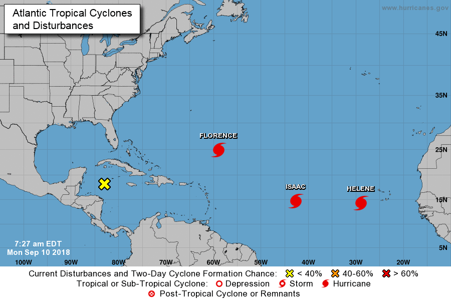
Man, I hate this time of year. Invariably, the tropics reach their crescendo, and this year is no different. In fact, this is only the 11th time on record that three hurricanes have been active in the Atlantic simultaneously, Florence, Helene, and Isaac. This week, Hurricane Florence will rightly suck up a lot of the national oxygen—Matt did a commendable job of summarizing the risks to the Carolinas and beyond, and they are tremendous in terms of flooding, wind, and surge—but we have some homegrown threats to consider as well.
For this post we are going to focus on the near-term threat of heavy rainfall on Monday and Tuesday, and then the late-week threat from a nascent tropical system. Did I mention that I hate this time of year?
Monday and Tuesday flood watch
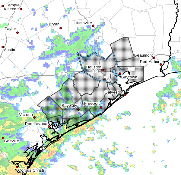
The National Weather Service has issued a Flash Flood Watch for the coastal and inland tier of counties for 1pm Monday through Tuesday morning, and they admit they may have to extend it. Basically, we have a lot of low pressure hanging around and a super-moist atmosphere. I think at best we can hope for scattered, heavy rain showers; and at worst we probably will see some spots of 3 to 6 inches over the next two days. Most likely the hardest hit areas will be along the coast, and if we’re lucky the heaviest rains will fall offshore.
Both Monday, Monday night, and Tuesday will probably be similar in this regard. We’ll just have to watch radar trends and if you have to drive for more than a short errand, you should probably check road conditions at your destination. This shouldn’t be anything more than street flooding, but we can’t guarantee that.

Wednesday and Thursday
Shower chances peel back slightly, falling from a near certainty to 50 or 60 percent each day. We might even see some partly sunny skies on Thursday, but I’m afraid we’re still going to have the threat of rain. It should shouldn’t be quite as heavy as we saw to start the week.
Next weekend and the tropics
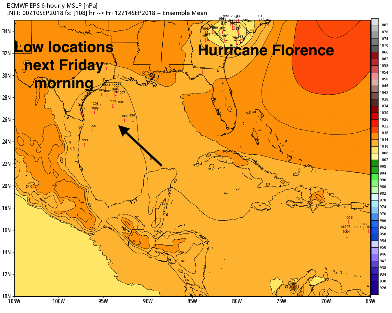
But wait, there’s more. The National Weather Service has started to track a blob of low pressure that should move from the Caribbean Sea, across the Yucatan Peninsula, into the Gulf of Mexico later Tuesday or Wednesday morning. Until that time it should face a pretty hostile environment for strengthening. But once in the Gulf it could find more favorable conditions. The National Hurricane Center gives this system about a 40 percent chance of becoming a tropical depression or storm during the next five days, and I feel that’s about right.
Where’s it going? Whatever this system becomes, it likely is coming to Texas. At least that the conclusion of the European model, which shows solutions this morning for most of the state’s coastline. Please bear in mind that without any kind of low-pressure center—which seems unlikely to develop before this mess moves into the Gulf—it is hard to have much confidence in what will happen with this system.
Here’s what we do know:
- As the tropical low moves into the Gulf of Mexico this week it has a chance to develop, most likely into a depression or tropical storm. But as this is early September, we can’t rule anything out.
- The system will bring increased tropical moisture into Texas, and this will result in increased rain chances, probably beginning Friday. Right now we aren’t seeing a signal for anything too extreme, nor can we say whether heavy rain is most likely for South Texas, the Coastal Bend, or the Houston-Galveston region.
- You should not be overly worried, but between the rains to start the week, and the potential for more heavy rainfall later this week, we definitely need to be weather aware for awhile. To that end, Matt and I will stay on top of things.
As always, thanks for your excellent work!
Matt and Eric, I was introduced to your site shortly after our move to Houston. We have seen Memorial Day and Tax Day flooding not to mention Harvey of course. Your insight and down to earth style help us navigate the coastal weather that is relatively new to us (originally from the Midwest). We love the state of Texas and rely on you two to help us prepare for the what’s coming with the weather. Thank you both!
You are quite welcome.
Eric is there any evidence to support unfavorable upper level winds once it gets into the gulf that will result in it staying for longer than expected?
Right now there is nothing to suggest the Gulf system will stall, which is what I think you’re asking.
That was the issue with Harvey. A high pressure area formed above it keeping it on top of Houston, right? Can you elaborate on this on your next post?
So glad you both take the time to be thorough in these forecast write-ups. When we have huge weather stories, it’s nice to have a long-form forecast. Current TV news isn’t set up for this- it’s set up for “San Diego weather”- “Well, it was 72 and there were 3 clouds today. Tomorrow, we’re expecting a 4th cloud, but no more than that. Here’s our long-range forecast of 72 and sunny through the weekend. Back to you, Jessica. Thanks, Bill.”
This makes life a little more certain.
Confused if “next weekend” means “this weekend”. Not sure if the tropical storms are coming now or in a week.
The top of the map seems to say 14SEP. So I’d assume it means this coming weekend.
I was confused about it as well.
That tripping tricking triplet will need well over a fortnight, like Christopher did, but travel much faster at nights!-) so they might eggshelley arrive on time for Satur- and Sunday, say. Weather Eye -and frog over and out.
Yippee. Still supposed to go to Raleigh tomorrow, and between Florence and our own blob, I may be there awhile.
They wisely canceled the conference,
Ugh and thank you for your factual, no hype reporting. Thank you to your sponsor as well.
Thank you Eric for this update! Although my dear Fulgencio and I have wonderful memories of that fateful spring break on the Yucatan, we sure hate hearing that word this time of year. Love to all!
Armando, I am glad you hold those memories so dear & we all hope there will be many more. You two were the first ones I thought of when I read we might be some rain! We all know how Fulgencio gets excited and nervous this time of year when storms roll through!
The tropical hierarchy is now complete: Hurricane, Tropical Storm, Tropical Depression, Tropical Blob. 🙂
Thank you so much for your blog. We found you last year while in Dallas for our Harvey hurrication. I’m starting to hate this time of year too, especially with homecoming festivities this week in Clear Lake. Stay dry! 🙃
Ugh Ugh Ugh !!
So, my dad is supposed to fly into hobby on Saturday night. What are chances this is going to be problematic? (He’s supposed to watch my kids when I give birth next week!)
Thanks for the great analysis as always Eric! Quick question – I’m going to be driving out to West Virginia later this week, probably arriving Friday afternoon. Do you think Florence will potentially have a meaningful impact in the WV area if it hits NC? I see everyone talking about the Carolinas, but can’t seem to get a bead on what it might mean for a little further N-NW.
Our family is supposed to fly into Dulles on Friday afternoon for a wedding in the DC/Northern VA area on Sat. Very curious as to what our chances are to actually have the flight as scheduled and if we will be stuck up there past our scheduled return flight on Monday.
I’m seeing some media reports suggesting Florence will be the Harvey of the east coast in terms of rainfall. Is that really a legitimate possibility?
The East Coast also has the issue of having received 125% of its normal rainfall, so a tropical download is well, not going to be good at all
I seriously doubt we’ll ever see another storm like Harvey. Fortunately for them, the Atlantic doesn’t pump in moisture as bad as the Gulf.
Hey Eric, your Ars Technica article on Florence is #1 on Google News right now!
https://arstechnica.com/science/2018/09/hurricane-florence-represents-a-grave-threat-to-the-east-coast/
Rubber boots and a raincoat are part of my daily attire. We live in Brazoria County (Angleton) where the dirt is clay. Our land tends to hold a lot of water because of it. Both in 2016 and 2017 we were waist-deep in water due to the flooding, forced to evacuate both times. Our house has never taken in water which is a huge blessing, but it’s no easy feat trying to evacuate with several dogs. We run a canine rescue organization so we have to take all weather threats seriously. I ignore the local news and rely wholeheartedly on this blog. On behalf of myself and my furry friends, thank you for the constant updates! Looks like we’ll be playing in the rain and praying for the best.
I’m terrified.
I leave to go on a Cruise to Cozumel leaving out of Galveston Thursday so from the sound of things we will be getting a decent bit a rain probably on the cruise.
Steve, you may want to have someone drop you off for your cruise or find a high water spot to leave your parked car. Lots of parking lots got swamped with high water in Ike and destroyed lots of cars while people were off cruising.
That’s a good idea. Would hate to coming back from vacation and have to deal with a flooded out car.
Eric,
I know it’s out of your area, but we’re in the Cancun area from now until Saturday, and then heading back to Houston.
Will we have any major rain from the depression as it goes over?
What’s the word on Isaac’s path into the Gulf (and us)?
Obligatory ‘What about Katy’ post….
No more, please. Enough.
I would start buying boards for the windows now to beat the crowds.
Supposedly September 10 is the peak of hurricane season. Therefore next week should be better, at least for Texas. Especially after Sept. 23 when storms become Atlantic focused.
Hang in there, Eric,
Many thanks for presenting the calm but realistic view of this weather system. You take the hype out of weather and give us a realistic picture of what to expect. I appreciate that very much.
No problem. Houston’s weather is usually lousy except for maybe one week in January.
Windy.com via the European model shows the Gulf storm coming ashore around Rockport Saturday morning. :[
Thanks for the windy.com site. I like that. I’ve been hooked to spaghettimodels.com
Thanks! Two urls snagged.
The weather service we use at work now has the yellow X thingy moving into near Corpus on Friday afternoon as a tropical storm. So much for a dry, Hill Country weekend….
Salwa