Tuesday, 6:20am CT— Good morning to all. Day four of Harvey in Houston is well underway. The end of the rain part of the storm is closer yet. For those curious about specifically how much rain has fallen, the National Weather Service did compile a brief list. Mutliple locations are over 40″ of rain total, especially southeast of Houston. Other locations have ranged from a lot to an awful lot.
Here are some rainfall totals from across Southeast Texas since last Friday. #houwx #Harvey pic.twitter.com/loeVZDWH8j
— NWS Houston (@NWSHouston) August 29, 2017
Now
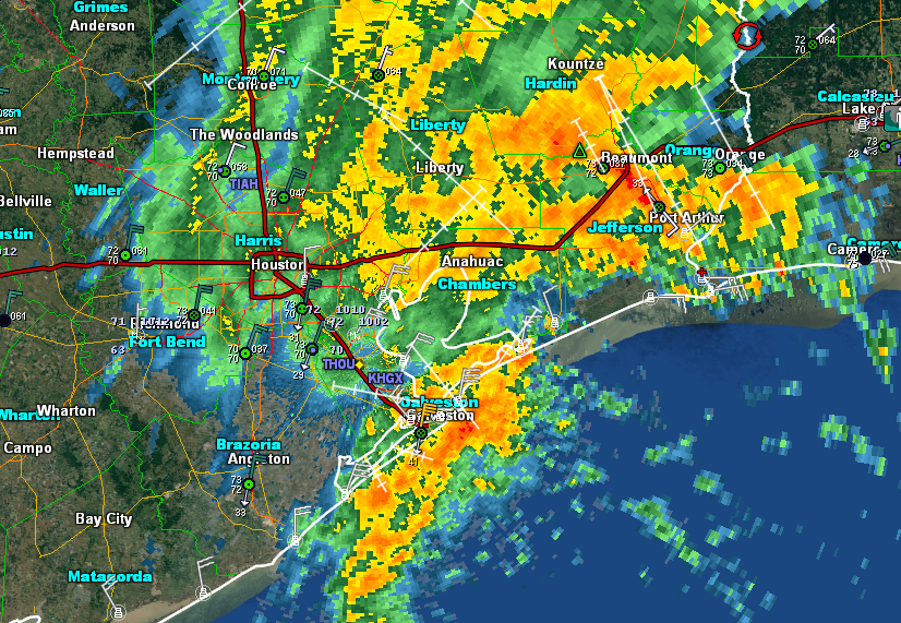
After a night of more rain, things have calmed down a bit in many areas this morning. Most rainfall rates are under 0.50″ this morning, except perhaps in the northeast corner of Harris County, and parts of Liberty, Chambers, and coastal Galveston Counties.
Any breaks are welcome of course, but we still have a little bit of a ways to go in this storm.
Today
Models seem to be struggling a bit handling the current situation, either overdoing it or underdoing it, so there’s a degree of uncertainty in the forecast today. If we look at a satellite loop this morning, the brightest clouds on this loop (essentially indicating the most moisture for thunderstorms) are clearly east of the area.
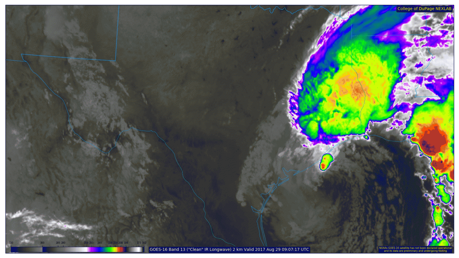
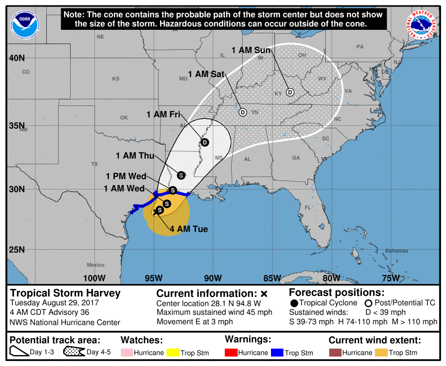
If you look offshore, there remains a little cluster of heavier storms on the north side of the center of Harvey (still a 45 mph tropical storm). Harvey’s eastward drift should become a northeasterly one later today. As this happens, it will probably fling back another wave or two of rainfall into the region, similar to yesterday or somewhat similar to last night. The heaviest rains will be east of I-45, while lighter rains will continue west of I-45. We should add up to a couple more inches at most west and perhaps 2-4″ (perhaps a few higher amounts in spots) or so east through the day today.
Tonight and Wednesday
As we go into the final phase of Harvey, and it begins to pull away tonight and Wednesday, we should see periods of rain once again, lightest west, heaviest east. Those should add up to another 0.50-1.50″ west of US-59 tonight through Wednesday evening and another 1.50-4″ east of US-59 and north of I-10. Some places will see less, others more, but this is about the average of what we should see.
The forecast for Wednesday night would have steady rain ending east of Houston, and Thursday should see just a few scattered showers. Friday and Saturday continue to look dry.
We’ll have more the forecast and flooding later this morning. Stay safe all.
Posted at 6:20 AM Tuesday by Matt

Any idea on how to currently drive from Dallas into Houston? Is there a passable route? Thanks for all the excellent coverage.
Traffic conditions between Houston and Dallas are looking OK, but Transtar still shows lots and lots of high water. If you can possibly give it another couple of days to drain, you’d be a lot safer.
That first link is a map from Dallas to Conroe. Conroe to Houston is where the problems start. At this time I don’t see any obvious routes from Conroe to Houston. Transtar cameras show I-45 empty. You can prob find a way into Houston, but will require hours of driving around looking for clear streets.
There’s another great map from txdot showing road water conditions in Houston—it’s a lot clearer and easier to parse than Transtar:
https://drivetexas.org/#/13/29.6782/-95.6068?future=false
My heart goes out to TX continued prayer for all however I need to hear about Brownsville TX where I have relative and need to hear from them what about Brownsville Brownsville looking for The Wood FAM. Gorge & Myrna please contact me…
Please, do not pray for Texas if you want the disaster to decrease. Pray with love and gratitude to the planet Earth for giving beautiful weathers over the South-East coast like it’s already happening…To many catastrophic news and fearful attention of the globe scaled the hurricane from weak degree to the highest.
“Ask and it shall be given”. “What we dwell on – grows”. Why do we forget about these laws after we just close the church doors behind ourselves?….
These are the real law of the Universe and they work as a clock.
WTF?
Dear Planet Earth,
Please shut up this guy.
Praying for All Amen dav
Thank you for these informative posts throughout Harvey. Having “just the facts ma’am” has kept me centered.
Would you be able to do a water reservoir and bayou and river update? I’m not asking for much huh?
You can get some of that info at water.weather.gov
On the water level monitoring sites, it shows that the barker reservoir gauge has been knocked out, so we would really appreciate a way to find out that data.
Leslie anders: hcfcd.org has links to gauges for bayou levels around the city
Thank you for the excellent work during this storm. We looked forward to your updates and very much appreciate you staying the course with your website even as you dealt with flooding in your own families.
Not sure if you’re trying to keep track of what is happening on the ground, but water is receding at Cypress Creek near Huffmeister–we’ve gone from 22 inches in our house to about 13.
I am so grateful for your efforts in keeping people informed. I look forward to your updates. I shared your site with worried relatives and friends in Texas and all over the U.S. to help them get precise information told from a personable, realistic, friendly and professional perspective. Thank you !!!! I am in Austin keeping track of my brother’s family and other dear ones in Houston.
For those of us watching, whose loved ones are in the Junction of this battling fate of Hurricane Harvey , your updates have an energy of calm , reality and just about the need of the minute , we take to breathe . It helps us stay positive and we wait the hours eagerly to reel back into a hopeful universe hoping to reunite with our loved ones once again .
If you where going to go down and pick someone up, would it be better to ask them to head to the Westside or North Side Woodlands area????
Thanks Tim
Thanks for the updates! Glad you got the NOAA map in there! Been a surfer most of my life…big part is using NOAA to figure out where the better surf is going to be. Not to mention decisions on how, what, if to batten down the house….or bail etc. For instance, hurricane Rita. Mass evacuation, people trapped on freeways for many hours going almost nowhere towards Austin, SA, Dallas.
I headed south to So. Padre….no traffic at all, west side of storm…the dry sunny side…4 days of epic surf.
Regardless….this storm was like none I have ever seen. Worried about the Biblical flooding potential….it happened. Hope people are safe.
Meanwhile…some craziness from kids:
http://www.thegatewaypundit.com/2017/08/must-see-video-crazy-teens-go-wakeboarding-tubing-houston-amid-flooding/
Thank you, Eric and Matt. I believe you both saved lives. You certainly saved my sanity.
There’s a lot of question and concern in the energy corridor and memorial area around buffalo bayou about what is being called uncontrolled overflow from addicks reservoir. Can’t find anything on the news about it though and it’s putting people into panic states. Can you explain the effect of this? The flood district website isn’t helpful.
“Uncontrolled release from Addicks Reservoir” refers to the water flowing from the emergency spillway on the north end near Tanner Road. There are several subdivisions and a business park immediately faced with flooding up there, but nothing immediately hazarding the Energy Corridor. There is this from Jeff Lindner at HCFCD: “The flow of water from the Addicks will move along Tanner Road to Beltway 8 to Brittmoore Road, and south toward I-10 to Rummel Creek and then into Buffalo Bayou.” It’s possible that portions of I-10 Katy Freeway could get flooded according to Lindner.
That’s a little worrying since I have friends living near Rummel Creek south of I-10, but it does not sound like immediate cause for concern unless you’re near Tanner and Eldridge.
When will victims of the weather be able to return home in the greenspoint area.
I second the request for info about the effect of the releases and overflow from Atticus will have on the Energy Corridor and the neighborhoods off of Eldridge between Memorial and Briar Forest. I know this isn’t necessarily within the scope of what you report on, but as others have indicated, it is impossible to find this information anywhere else. Thank you for whatever you can do to shed light on this.
Will cresting if area rivers affect us? And are the reservoirs safe from
Collapse? Thank you so much.