Happy Sunday everyone! We hope your weekend has been going well so far. The weather has certainly cooperated for the most part. The rest of today should behave similarly. We just wanted to post about a couple things since we sort of left the weather situation for the upcoming week on an open-ended note on Friday. We’ve gotten a good bit of clarity over the last couple days, which, as it turns out is good news for us.
This evening & Labor Day
As noted on Friday, we do expect conditions to become a little more unsettled heading toward tomorrow. If we look at a quick surface weather map of the region, we can see the main players. First, we have a weak little trough (orange dashed line) dropping southeast across Texas today. That could focus a few showers and storms tonight, and this would primarily be north of Houston.
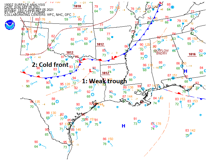
The second item to note on that map is an actual cold front. Sadly, this isn’t going to be a classic autumn cold front, but this may be just enough to help lower humidity a little for the week ahead, particularly during the afternoon. Instead of nighttime lows in the mid to upper-70s, perhaps we’ll have a few mornings in the low to mid-70s this week. For those seeking that true pumpkin spice latte weather, this won’t be it, but it will be a start.
More importantly, this front will serve as a focal point for scattered thunderstorms on Monday. I would not be shocked if we have some activity in the morning and then a break with more in the late afternoon. Storms tomorrow afternoon could be on the strong side with locally heavy downpours. Just keep that in mind if you’ll be traveling to or from somewhere or hosting an outdoor BBQ. Probably good to have a backup plan for the BBQ, just in case. Outside of rain, it should again be in the 90s tomorrow.
Tuesday through Thursday
Back on Friday we told you about how models had gotten a little more excited about the potential of a tropical system in the Gulf. For us, some good news: Whatever “that” is should not develop much, and it will almost certainly miss well to our east.
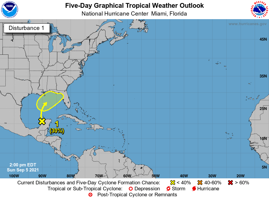
The National Hurricane Center is continuing to assign about 30 percent development odds over the next 5 days from Invest 91L, now emerging in the Bay of Campeche. But the upper level pattern will feature a strong ridge in the upper atmosphere that builds from about Las Vegas on Monday to the Four Corners on Thursday. That eastward expansion of high pressure in the upper atmosphere, combined with a pretty strong trough in the eastern U.S. will likely help deflect the tropical noise into the central or eastern Gulf. This leads our rain chances to drop in the Houston area Tuesday, Wednesday, and Thursday. Obviously we don’t want to see Louisiana face yet another tropical threat, but thankfully whatever does develop here (if anything does at all) should be weak. That said, some heavier rain is possible in the eastern Gulf from this system. As of right now, official forecasts are only about 1 to 4 inches, aimed mainly at Alabama and the Florida Panhandle.
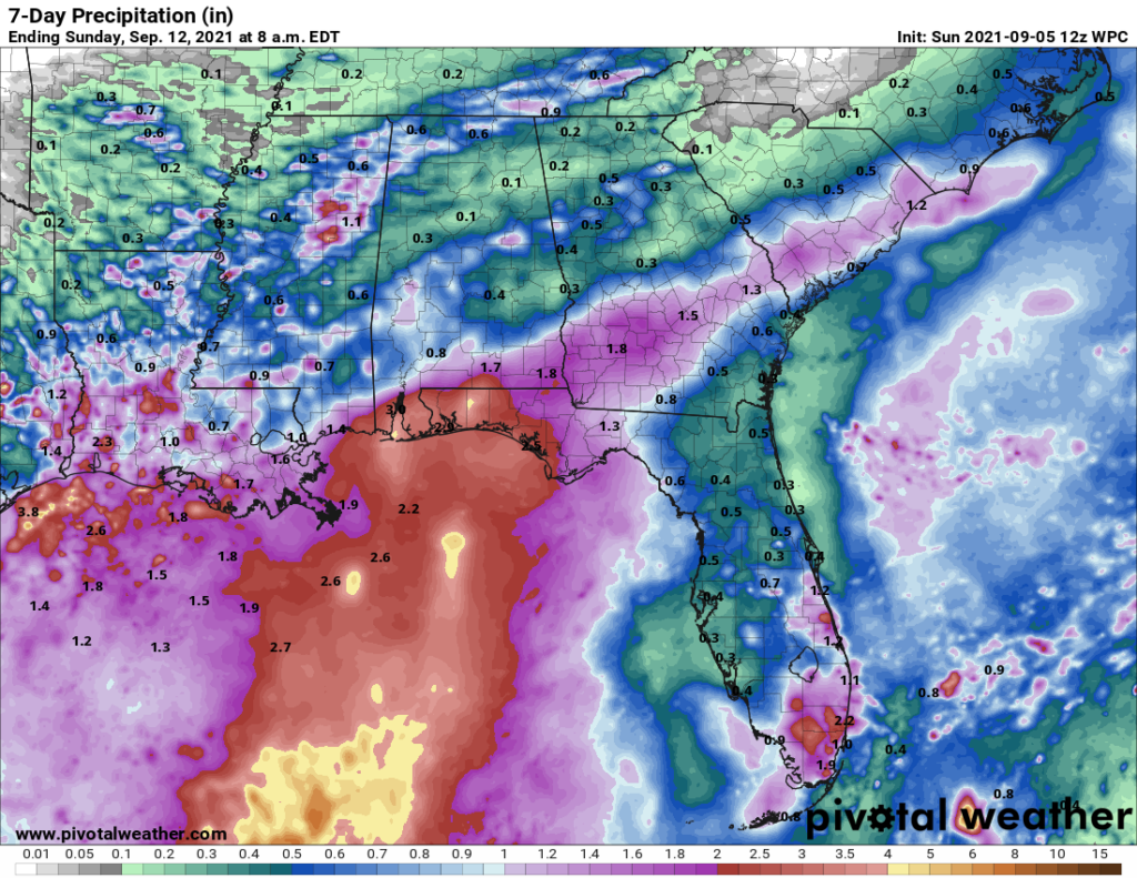
Some locally heavy rain is possible in Louisiana from this, but the primary focus is likely to stay east of there as well. We’ll keep watching, just in case, but we feel fairly good about the upcoming week overall for the Houston area.
Beyond next week: Other tropical threats?
There have been some posts circulating on social media regarding various deterministic (singular) model runs showing a hurricane in the Gulf around mid-month. I’ll be honest, the operational GFS has been quite consistently showing a system (of varying intensity) in the Gulf around mid-month (sometimes in Mexico, sometimes in Texas, sometimes elsewhere). While the GFS ensemble has been, in this forecaster’s opinion, one of the best tools to use in the tropics to identify possible threats the last two hurricane seasons, the GFS operational model still has many flaws. This is especially true on a day 10+ forecast. I don’t care how consistent it has been showing a certain outcome: It is still a day 10+ operational forecast model, and it is *not* meant to be used with any specificity whatsoever. While it’s nauseating to deal with this stuff multiple times per hurricane season, it is the world we presently live in, and so let me be the one to tell you: At this time, you do not need to be worried about the threats shown on operational models that various, mostly anonymous Facebook pages are sharing.
Ensemble support for this system is not zero, but it’s not at a high enough volume yet where I begin getting concerned. And there is absolutely no dominant signal within the ensembles as to where such a system may or may not track even if it develops. Some show Mexico, some show Texas, some show east of here, some (roughly half) show no development at all! We see scenarios like this show up multiple times per hurricane season. Sometimes they lead to development. Often times, they do not. So, could this change? Absolutely, but sitting here today it would irresponsible to pump up the operational GFS model on day 11 without showing the ensembles at the same time which paint a less ominous picture. Let’s talk when it’s inside 7 days and see where we stand. It is the peak of hurricane season, so you should be checking in regularly anyway. But we see nothing exceptional at this very early stage.
Alright, that’s enough for now. Enjoy Labor Day if you’re able, and we’ll come back at you on Tuesday with the latest.
Thanks for posting on a Sunday Matt!
Thank you so much for keeping updated!
Thank you Matt!
Thank you for a very thoughtful, cogent and understandable summary of the Tropics
Cold front ? Cold front ? Be still my beating heart !
As always Lanza. You are the man.
I saw the week of Sept 11-18 that on the models, wind shear is high in the Gulf. Hopefully this means whatever that is showing on the GFS is no real threat that week.
And the Euro is not showing that system unlike the GFS.
Thank you for all your efforts to keep us well-informed !
I deeply appreciate you taking the time to post an update on a holiday weekend, Matt.
Thank you for this important tropical update.
Add me to the chorus of thanks – I normally only expect an update on weekdays but decided to pop in here now since it is a sleepy hot Sunday.
Glad to read that the blob in the Gulf doesn’t have much predicted chance of developing and it will be flung towards the FL panhandle.
Love you guys.
Thank you for the updates!!
Thanks a whole lot for your updates!!
Thank you, Matt.