Good morning. It’s rather warm outside for early March, with temperatures in the low 70s across much of the metro area with 90 percent humidity. Normal lows are about 20 degrees colder. We’ll have two more warm days before a front moves into the region late Thursday evening. This will bring a chance of storms, and then set the stage for a fine, sunny weekend.
Wednesday

The record high temperature for Houston, on March 1, is 84 degrees set back in 2017. I think we have a healthy chance of besting that as highs perk up into the mid-80s today with sticky dewpoints. Temperatures will be boosted by partly to mostly sunny skies, and a south wind at 10 to 15 mph, with higher gusts.
If you’re scooting your boots over to the rodeo this evening to see Brooks & Dunn, temperatures before the show will be about 80 degrees, with increasing clouds. Winds will be southerly, at about 10 mph. Post-show temperatures will be mild, in the low 70s. So really, there are no issues to worry about. Low temperatures tonight will only bottom out at 70 degrees.
Thursday
Skies will be mostly cloudy on Thursday, and this probably will limit high temperatures to the low 80s. Based on our latest guidance I don’t have any real concerns about weather during the daytime. We can’t entirely rule out a few scattered showers, but it should be nothing significant. However by around sunset, the cold front should be close to the far western edge of the Houston metro area, and push into the downtown area by around 9 pm to midnight, and be off the coast a couple of hours later.
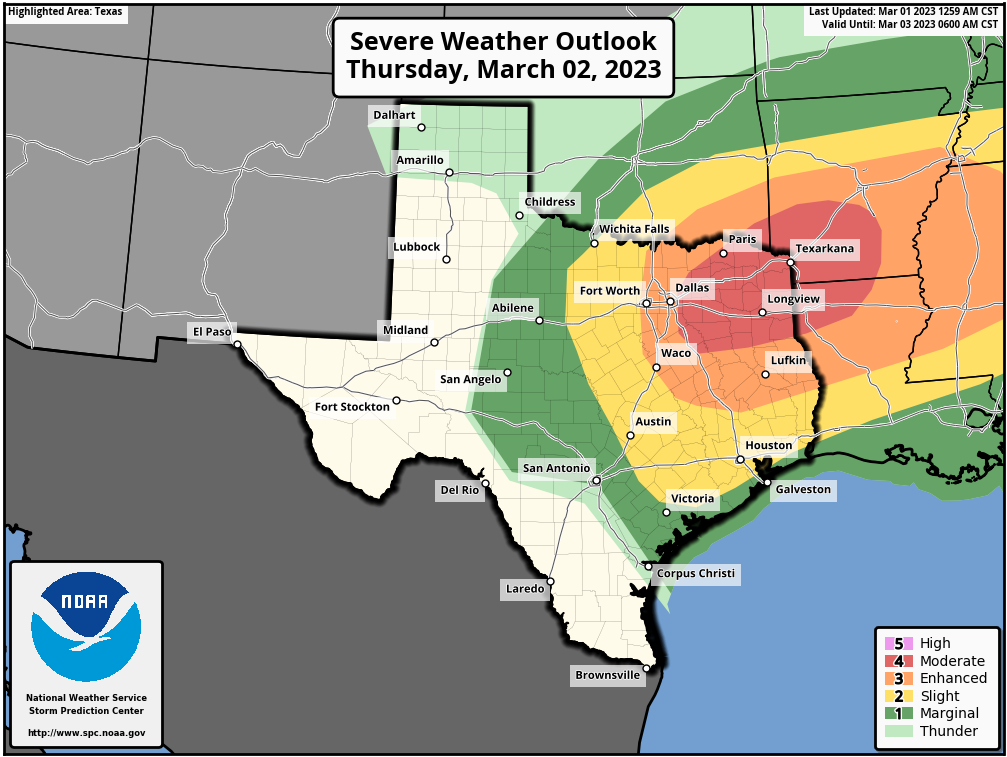
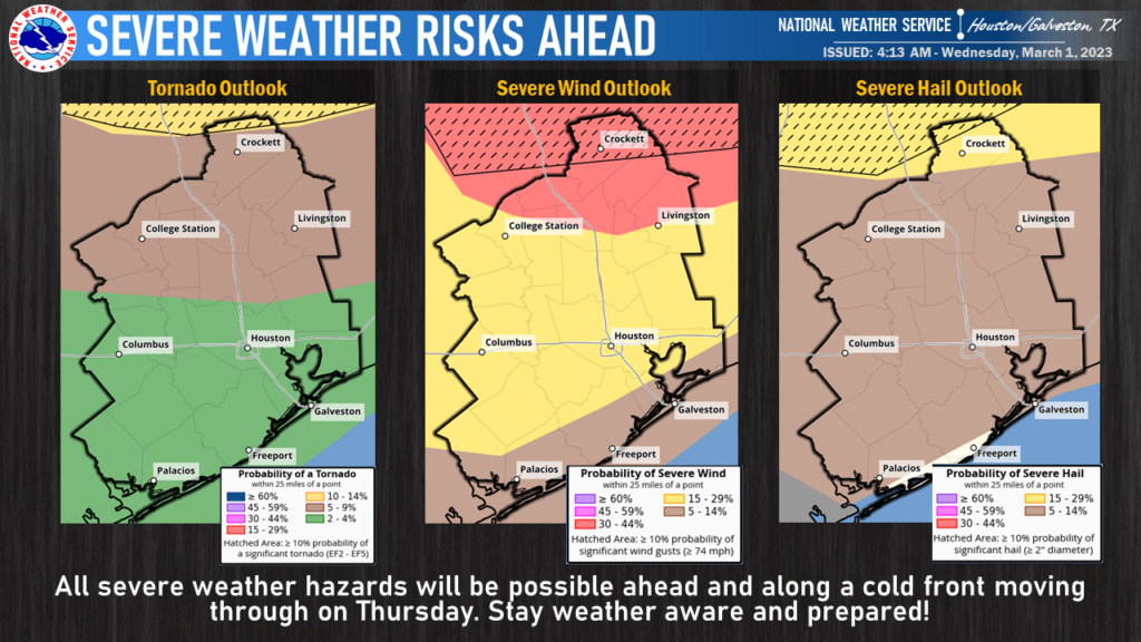
So what will happen as the front passes? My sense is that, for most us, probably not too much beyond some light to moderate rain. The potential for severe weather will be greatest well to the north of our region. Areas such as Dallas, Longview, and Texarkana are at a significantly higher risk for severe weather, such as strong thunderstorms, hail, damaging winds, and potentially tornadoes. Closer to Houston, those risks will be tempered by a capping inversion and less favorable dynamics for storms.
The bottom line is that on Thursday evening we’ll need to watch for thunderstorms in Houston, especially for areas north of Interstate 10, as well as other severe storm threats. This is not something I’m overly concerned about, but the potential is there. Most of the region should also see some measurable rainfall, perhaps one to two tenths of an inch. So flooding is not a concern. Lows will drop into the 50s on Thursday night following the front’s passage.
Friday
Look for sunny and breezy weather, with highs in the mid- to upper 60s. Friday night will be the coldest of the week, likely dropping into the 40s for the region.
Saturday and Sunday
The weekend will see continued mostly sunny skies. Both days now look to have high temperatures in the upper 70s. Lows on Saturday night will drop to around 50 degrees, but Sunday night will be warmer as the southerly flow reestablishes itself.
Next week
Most of next week should be warmer, with highs in the 80s, before some sort of front arrives by Thursday or Friday. Days look to be partly cloudy, and nights fairly humid. Rain chances look low, for the most part, until the front’s arrival.


Eric. I’ve read rumbling about an artic blast coming down in March some 10-15+ days from now that has a potential for light freeze for the Houston area. Have you seen anything about this?
I heard the same thing….hope not, as I put my tomatoes in the ground this past weekend!
That would be nice. Save for the December cold snap, winter has been non existent around here this season.
I think it would be super interesting if you could make a post comparing past severe outlooks with what actually materialized. Maybe once per quarter.
It’s so soup-y! Can we reasonably expect more pleasant spring weather at some point? Or might we be looking at mostly 80+ from now until November?
These early spring capping inversions are why we always seem to get into drought this time of year, aren’t they.
Does La Niña strengthen capping inversions in spring?
Yes. During La Nina the jet stream tends to position itself more north of Texas in an arch like configuration especially during the spring. This causes the low pressure systems that are attached to colder air masses to be steered north of Texas. This causes warm dry air from the mountains of Mexico to flow right over Texas since air from all surrounding areas falls toward the center of low pressure in a counterclockwise motion. This warm dry air aloft from the dry desert mountains then prevents the warm moist air from rising high enough to cool and condense into rain and storms. This is a phenomenon that occures every year off and on even during El Nino years. But it is definitely more frequent during La Nina years. 2011 was one of the best examples of this. A strong atmospheric cap prevented us from getting much rain at all during the spring which led to one of the worst droughts in Texas history. That was during a moderate to strong La Nina.
file:///var/mobile/Library/SMS/Attachments/53/03/9FE62B15-CB1B-457F-83FE-B94244EA6419/IMG_5931.png