Houston remains in a warm pattern that’s going to persist for a few more days before some kind of cold front is likely to drag through the area next week. We may also see some showers related to Tropical Storm Nate this weekend, but nothing we should be too concerned about.
Friday
Mostly sunny and hot, with highs in the upper 80s. Not much to say about today, other than it’s going to be a typical, late-summer day for Houston.
Saturday & Nate
Tropical Storm Nate should emerge into the Gulf of Mexico early on Saturday morning and move north fairly rapidly, likely reaching the northern Gulf of Mexico coast by very early on Sunday morning. The high-confidence forecast track from the National Hurricane Center looks like this:
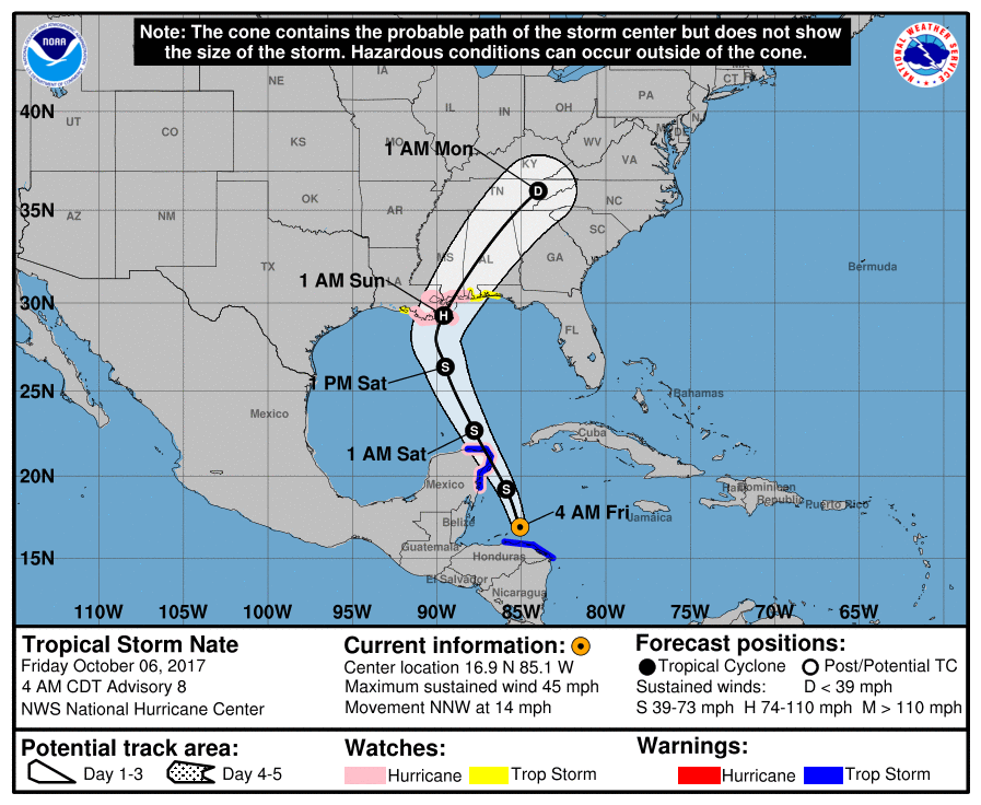
Along such a track, Houston may see some precipitation from the outer bands of the storm, but this is nothing we’re too concerned about. Likely, it won’t rain for most people, and accumulations seem unlikely to be more than 1 inch for those that do see rain—if that much. Nate should also keep tide levels higher than normal for the next day or two along the upper Texas coast.

At present, Nate is causing significant flash flooding in parts of Central America, and may bring similar conditions to the Yucatan Peninsula later today. Some intensification is likely today, as the storm passes over very warm waters in the western Caribbean Sea. Depending upon its interaction with the Yucatan land mass, there is some uncertainty about Nate’s intensity as it approaches the northern Gulf of Mexico coast. Right now most of the guidance keeps Nate as a tropical storm, but given the warmth in the Caribbean (and to a lesser extent, the Gulf) we can’t rule out rapid intensification over the next 24 to 48 hours. The storm may lash the US Gulf coast with rain, particularly from Louisiana to the Florida Panhandle, but the storm’s rapid movement should (somewhat) mitigate flood conditions.
Sunday and Monday
As Nate moves inland and rapidly away from the Gulf coast on Sunday, we can expect continued fairly warm weather, with highs near 90 degrees and warm nights. Some isolated showers will be possible Sunday, with scattered showers possible later on Monday and Monday night ahead of a cold front approaching the Houston area.
Cold front
Some people have asked if the cold front is really coming to Houston next week, because it disappeared from the 7- and 10-day forecasts on their weather apps on Thursday. (This is because the front dropped out of the GFS model for a time). We still do think it’s coming, although I’m not 100 percent confident. Right now most model guidance still brings in a significantly drier and somewhat cooler air mass into Houston next week, likely some time on Tuesday. I’m still not confident in predicting how cool, but I feel pretty good that we’re going to end this 90-degree-day type weather. We’ll continue to watch this closely because we know how desperate a lot of you (present company included) are by the continued summer-like weather.
Thank you for your weather reporting. Yesterday my wife asked me to repeat your update on the Tropical Storm because she said all she was reading on her news apps was that we would be in undated and blasted by rain from Nate. Late last night she asked if we should go to the market for food/supplies.
I repeated the thrust of your reporting is hype-free and that being steady and as concise as possible doesn’t create drama/excitement/viewers.
So thanks again! I guess the large media outlets are latching onto TS Nate as trouble for us even…
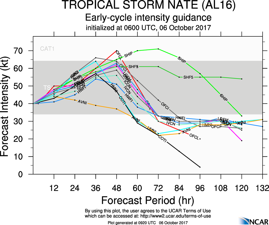
There should be two vertical lines on the intensity forecast indicating the approximate zone of expected landfall timing.
It’s pretty much where the intensity drops off rapidly at 48hr. That’s landfall…
The reason (as I understand it) as to why the SHIPS model looks different is that this is a statistical predictor that looks at strengthening factors based on historical data. It needs to be used in conjunction with other models that actually run fluid dynamical simulations (that’s probably a gross oversimplification!)
What you are getting from the SHIPS is a risk weighting of rapid intensification which is still challenging to predict > 24 hours out.
With infrastructure said to be weak, is there any risk of power outages in Houston from any squalls from Nate’s outer bands, Eric?
“We’ll continue to watch this closely because we know how desperate a lot of you (present company included) are by the continued summer-like weather.”
Stuff like this makes this such a great site. Thanks again!
Any idea on the next-after-next cold front? Anything on the horizon for the weekend of the 14th?
I’ve got fishing buddies in Gavleston, Corpus Christi, and over in Florida (still on the Gulf side) all reporting high tides that are significantly higher than usual. We’ve obviously got a big moon going – hard to miss out there tonight – but can that account for all of the delta from a ‘normal’ full moon tide? Or could Nate be contributing with some surge despite being awfully far away?
Strong easterly winds the past few days in the GoM have also contributed to higher tides. This has served to help push water up into the bays and inlets.