Happy Monday, y’all! We tacked on two more 80 degree days over the weekend, bringing our 2023 total to 18, tying us with 1974, 2000, and 2017 for the second most to start a year. The pace of this early spring warmth is really going to begin to slow down, however. You may have felt the change a bit yesterday afternoon once the cooler air behind the front settled in, along with the breeze. You’ll be feeling more of that in the future.
Today
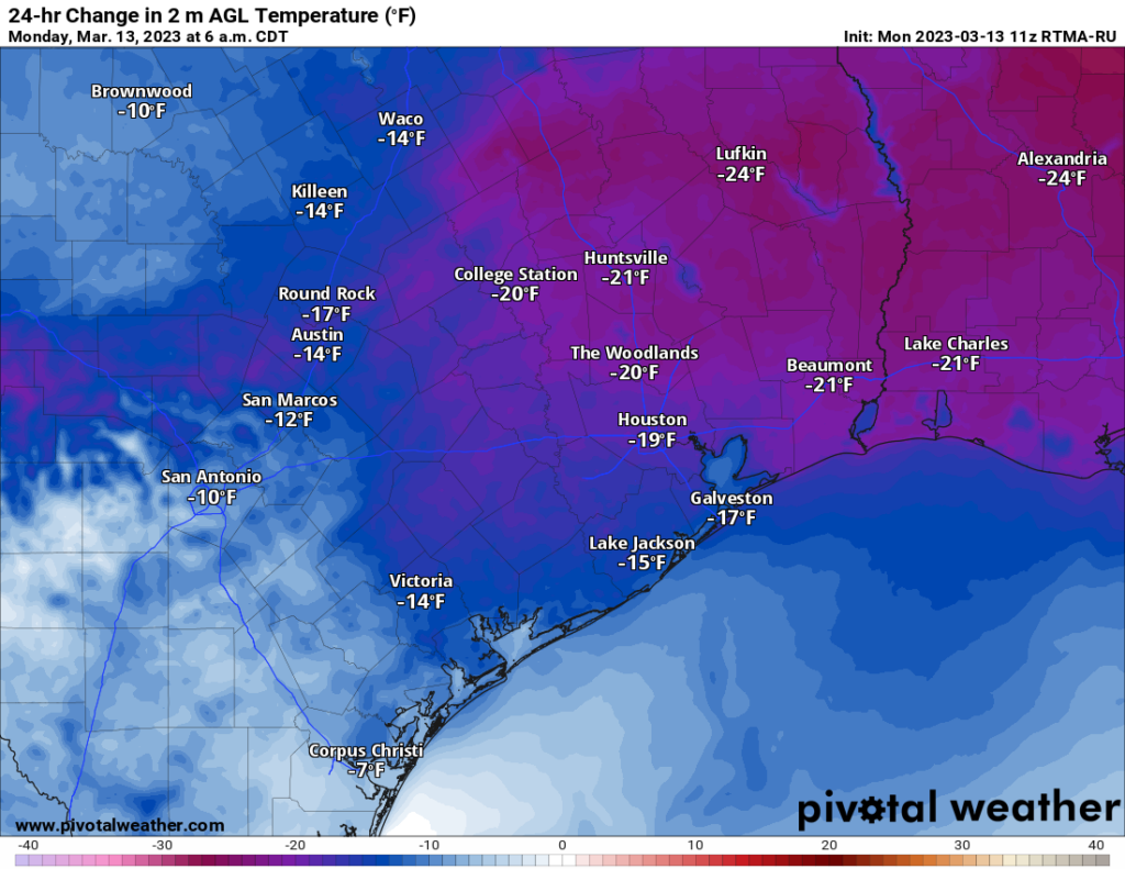
All is calm behind yesterday’s front. Temperatures cooled off late yesterday, and this morning, we’re running about 15 to 20 degrees cooler than 24 hours ago.

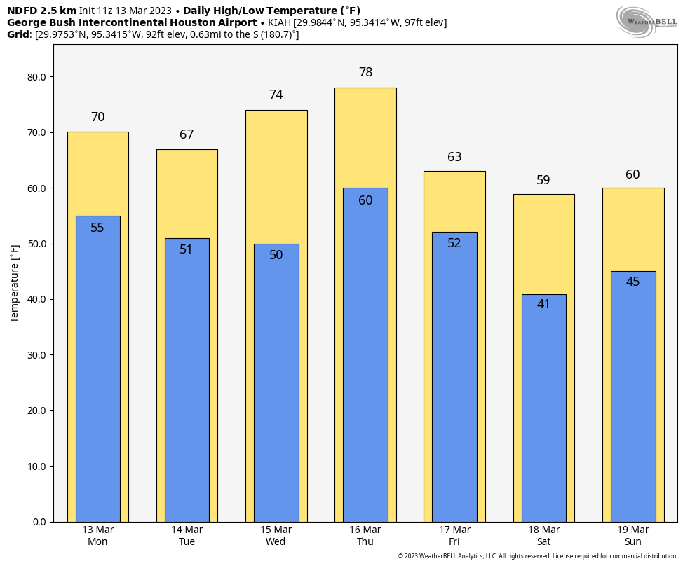
Today will be a mixed day with clouds and sun, with probably more of clouds than sun this morning and hopefully more sun than clouds this afternoon. A shower is possible in the Matagorda Bay area. The breeze that kicked up on Sunday afternoon will relent some today, easing up to about 10 to 15 mph or so a bit later, though maybe still a bit gusty over the water. With enough sun, we should manage 70 or so in most of the area, though places north of The Woodlands, west of Katy, and up in the Brazos Valley may generally stay in the 60s.

It’s Cody Jinks debut night tonight at the Houston Livestock Show & Rodeo. Depending on your personal preference, you may need a light jacket. You’ll get quiet weather at least. Temperatures will be in the upper 60s on your way in and low 60s on your way out. Keep the fair weather coming please.
Tuesday
Look for a mix of clouds and some sun tomorrow. As the Northeast gets walloped with what I think is their biggest winter storm of the season, we’ll get clipped by a weak disturbance. I wouldn’t say that showers are likely tomorrow, as the air mass overhead is still pretty dry in the wake of yesterday’s front. Just don’t be shocked to see some raindrops. But I wouldn’t alter outdoor plans. Temperatures will probably struggle a bit, with morning lows in the 50s and daytime highs mainly in the 60s, perhaps 70 or so southwest of Houston.
Wednesday
No trouble here. Wednesday will be arguably the nicest day of the week, with plenty of sun expected, morning lows in the 50s, and highs in the low-70s, along with comfy humidity.
End of the week
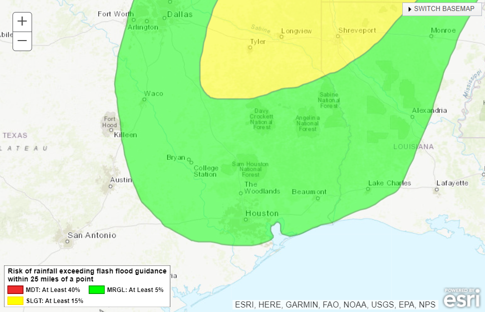
If you have not solidified your plans for the week and want to play the weather for outdoors-y activities, keep a close eye on Thursday and Friday. While most of Thursday may end up being fine, there’s still a decent chance at some showers or thunderstorms by late in the day, especially north and west of Houston. Friday looks even dicier with a period of showers and storms likely as a pretty strong cold front pushes in.

Some of the storms late Thursday and Friday could be on the stronger side, but the highest odds of severe weather and heavier rainfall are north of our area. Still, we’ll watch this through the week to see how it evolves.
Temperatures will surge on Thursday, perhaps approaching 80 degrees again before Friday’s front cuts things down heading into the weekend. As advertised, it does appear we are heading into a period of much cooler weather for the weekend into early next week. In fact, high temperatures on Saturday may not even reach 60 degrees!

We will probably warm up again into mid or late next week, but the amplitude and duration of that warming will probably be somewhat less intense than we’ve had so far this early spring.


Most assuredly, the coolest and driest day of the week is the best, regardless of sun.
Very bluster winds down here in Kemah/League City!
Next weekend looks like “get the house ready for summer” weekend.
Love the cool weather, hate the junebugs – I go outside and the things just live to dive-bomb me. Wish I could just sit in my back yard and relax.
Can you explain the much drier than usual weather our area and much of Texas has been having since a rainy January? Watching California get pounded and much of the country to the north but too warm, too dry here day after day, it seems.what is the “big picture” on this? P.ease and Thank you! Love this site and we rely on you for detailed scientific information.
There isn’t a very easy way to explain this, but I will do my best. The polar jet stream which steers cold air masses and low pressure systems has been tracking north of Texas through most of the winter. Because of the further northern position of these low pressure, the majority of the rain stays to our north. This is mainly because winds spin in a counterclockwise motion around low pressure areas. This causes warm and dry air from the desert mountains in Mexico to be transported over Texas since air in all the surrounding areas falls toward low pressure centers. This caps our atmosphere in the mid levels and prevents the warm moist air at the surface from being able to rise high enough to cool and condense into precipitation. This jetstream pattern is very common during La Nina years. To fix this we need a strong low pressure system to dive further south into Texas. This helps our winds leading toward the cold fronts associated with these lows to blow more directly out of the gulf which improves our chances of getting soaking rains more likely. It’s easier to understand this by looking at surface weather maps.
Yeah, it’s been quite active out in California, but the storms are basically being fed into the coast at an angle, so they lift north and east and avoid the southern Plains. Grand Forks, ND for example has had one of their longest lived deep snowpacks on record this winter. So those areas keep getting hit. We end up too far south and too “ridged” in the upper atmosphere to generate much moisture. As noted by another reader, this isn’t uncommon for a La Niña winter, but then again, this much rain & snow in California is quite uncommon for a La Niña winter. So what’s happening here may be tied to La Niña, but it’s clearly not the sole driver of things right now. Whatever else is happening in the background of the atmosphere is contributing. Eventually it’ll break. Hopefully just not too much too fast!
Like another person said: the coolest and driest day of the week is the best.
And, I’m with Blackhawks Fan that my thoughts turn to “last best chance to get house stuff done while the weather is decent and before the hot wet blanket of Houston climate is back”. I’m even plotting to ask off for Friday so I can have one more day of “good weather/house project” time.
Hopefully the rain will be low on Thursday around 4:30 PM in Crosby. It’s our big wedding day!
sounds like spring time weather. It makes more sense to have a little cooler weather rather than warming into the 90s starting in early March until Thanksgiving. The wind is annoying though. I like the time of year in late winter/early spring and early autumn when utility bills are low, with no need for heat or AC
Does cooler weather means less pollen? This allergy season has been horrible to me.
I’m wondering if that actually will help extend allergy season. I don’t think it’ll get cold enough to stop it, but it may slow down the intensity some and just prolong it a bit.