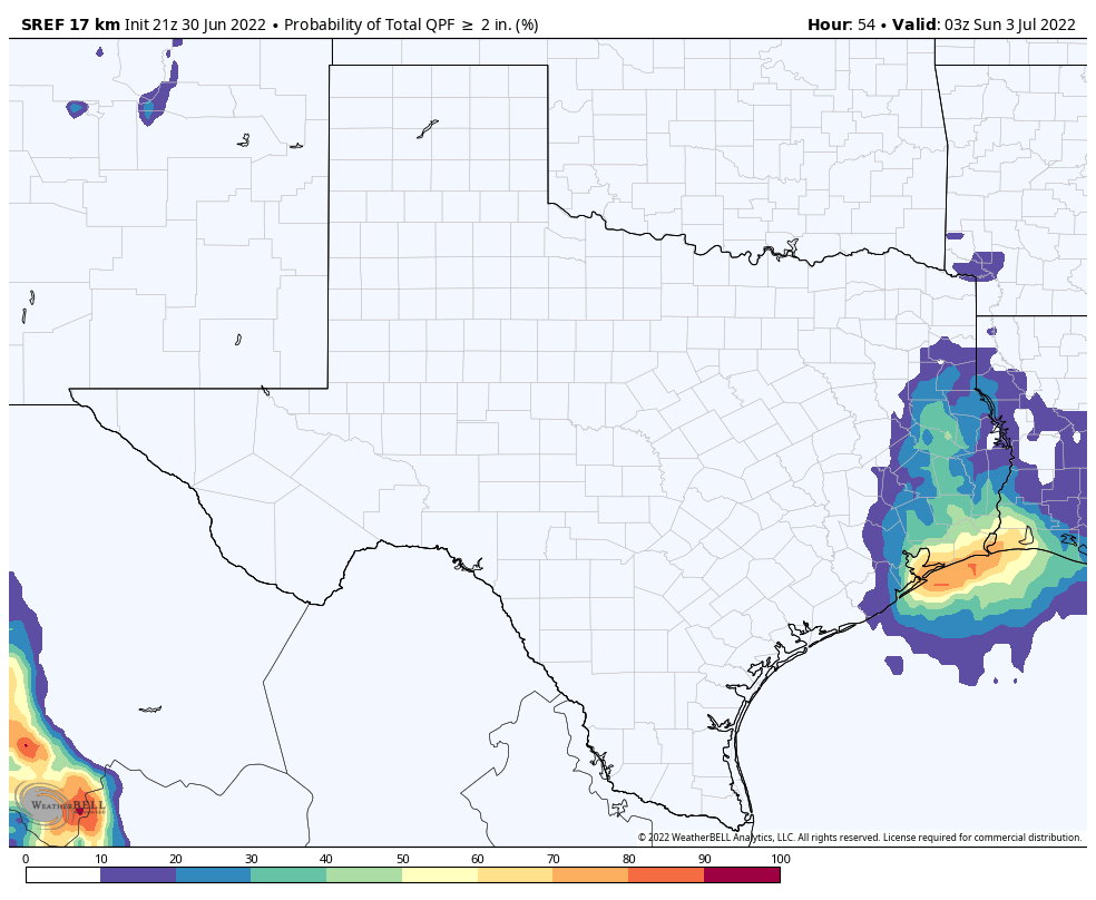
Good evening. This is just a quick post to say that we no longer anticipate the threat of widespread, heavy rainfall in the Houston metro area tonight and on Friday, including most of the coast. Therefore we are lifting the Stage 1 flood alert presently in place for coastal areas. This afternoon and evening, high-resolution forecast models have continued to trend eastward with the heaviest precipitation from a tropical system, away from the Houston region, and we can no longer justify such an alert.
Speaking of the tropical system, it has now moved inland into South Texas, and should turn more or less northward. We therefore expect that its heaviest rains will remain offshore for the most part, before impacting eastern Texas, including the Beaumont and Port Arthur areas, as well as southwestern Louisiana during the next 24 hours.

That is not to say that Galveston and Chambers counties won’t see rainfall. But I now anticipate that 1 to 4 inches will fall along these coastal areas, with the potential for greater totals and more significant flooding off to our east. As for the city of Houston itself, Harris County, and the rest of the metro area, we’re just not seeing a strong signal for heavy rainfall. A few areas of the city may see 1 to 2 inches of rain tonight and on Friday, but for the most part we should see considerably less. Impacts likely will be minimal.
While we have tried to be careful to emphasize the uncertainty in this forecast in recent days, and the likelihood that rains would be most prevalent along the coast, I know a lot of you were hoping to get some drought-busting rains with this tropical system. In that sense, I am sorry to say, it is likely to be a bust.
Drought 1, Houston 0.
Your forecasts are a breath of fresh air…pardon the spot on metaphor. I like the direct language, lack of the 10 day cast (no one ever gets that right), and the clever and familial writing style. Keep them coming!
It’s perplexing to me why the National Weather Service has not updated its forecast much at all even at this late hour, when you and all of the TV meteorologists are calling this a bust for most of us. They still show 2+ inches for my area and they have the same graphics for the entire area on their website as they’ve had all day, “heavy rain possible” (as I write this at 10:37PM, take a look: https://www.weather.gov/hgx/) Are they just slow to update their forecasts? If so, they need to work on this.
Yea, it was obvious when I checked Weather Underground about 8am this morning, there’d be zero rain …
I appreciate the 1.5 inches we got in Clear Lake. Hope the rest of the city gets something soon.
I just don’t understand how the computer modules could be so far off base. It’s almost as though they no longer exist. Whatever progress was made in prior years has completely disappeared. It just doesn’t make sense. It’s almost as though it was tweeked on purpose to take away any reliability.
Weather Illuminati
Well my gosh! We are getting a lot of rain right now in Northern Brazoria County! Hallelujah!!!
As of 6 am on Friday morning we have had less than a half inch of rain at my place in Santa Fe, from this much ballyhooed rain event.
🥲