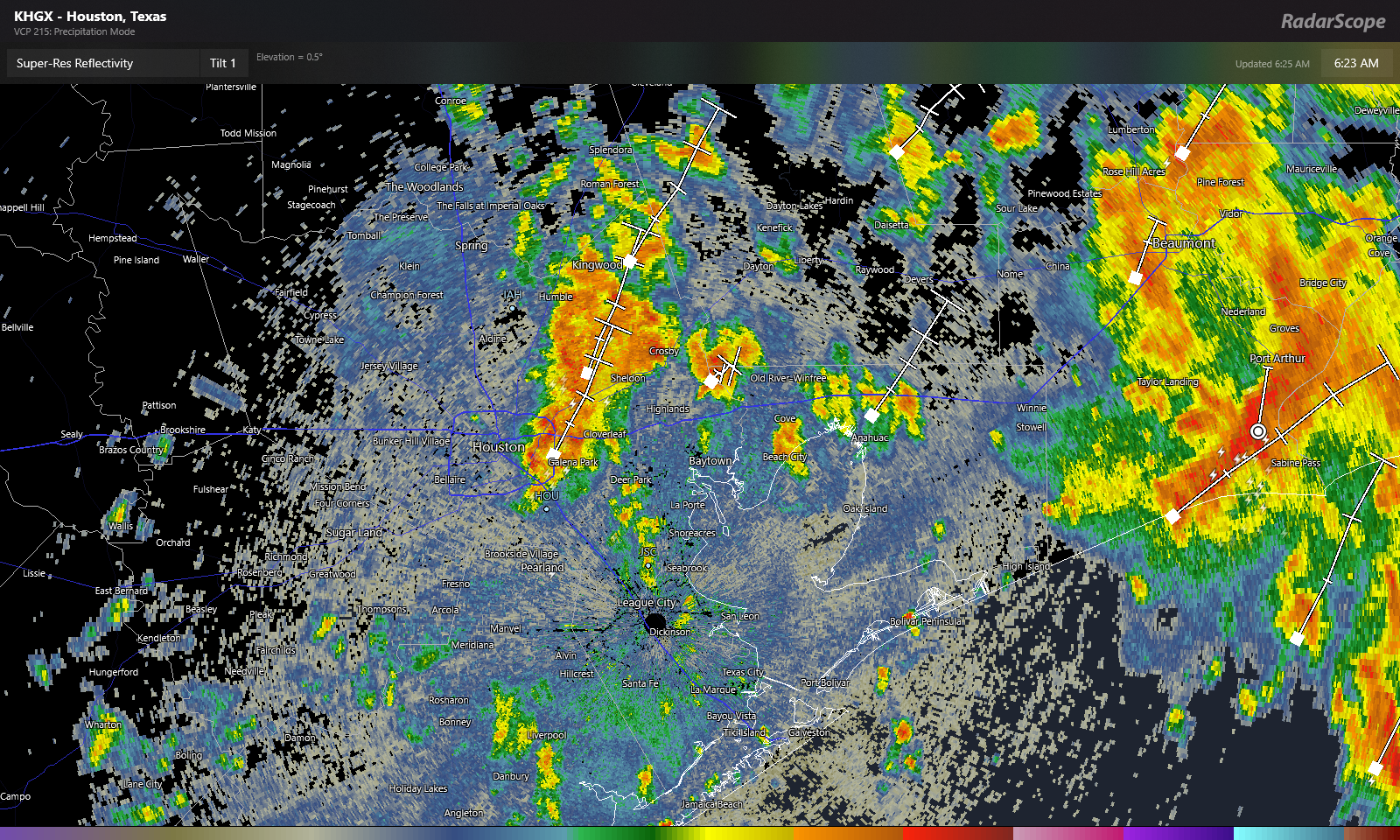
Good morning. It’s pretty evident that the heaviest rain will fall to our east today. That said, there are still storms and heavy ones at that in the area. A storm east of downtown dumped nearly 3 inches of rain in an hour as of 6:20 AM, where Brays Bayou crosses Lawndale Street on the East side. That amount of rain that fast can cause street flooding, so do keep this in mind this morning as these downpours lift north and east across the area. You may encounter street flooding, so please use caution and don’t drive through flooded roadways.
So with all that being said, obviously, this will probably end up a very disappointing system for our region as a whole, especially if you live on the west side. Coastal areas did well yesterday, and today’s rain will certainly be welcome. But still. While we aren’t heading back into the pattern we had in June, at least not as extreme, it will turn hotter and drier again. We’ll have some daily rain chances to cling to each day, but that’s a proverbial drop in the bucket in terms of what is needed to eradicate drought.
Speaking of, the drought monitor update from yesterday, which includes rain through Tuesday showed that drought had expanded to cover virtually the entire Houston region now, a very large increase in such a short time.

Depending on how the next few weeks evolve, this could start to become a very bad drought for our region, or just sort of hang in place “as is” for awhile. I’m personally not particularly optimistic given both nearer-term guidance and longer-range guidance, which continues to suggest below average rainfall. With the holiday weekend celebrations ahead, please be mindful of burn bans (which cover almost the entire state), and please be extra cautious with fireworks this year. I have not heard of any local fireworks bans beyond already existing regulations, but that doesn’t mean dry ground can’t ignite in some accidental situations. So the best advice is to use more caution than usual this year.
Rest of today
This morning’s rain and localized downpours will continue off and on through the morning, likely shifting east and weakening this afternoon. Most areas east of I-45 will see some rain, but amounts will widely vary from another 1 to 3 inches in spots to just a few tenths in others. West of I-45, you will see isolated showers or storms, with many spots seeing nothing. The exception will be south of Houston. Areas across much of Brazoria and Galveston Counties will continue to see scattered storms into early afternoon.
Readers checking us out from Beaumont & Port Arthur will note some very heavy rain, especially in Port Arthur this morning. I would presume street flooding is likely to begin there soon on a wider scale basis. Use caution in that area this morning.
We only managed 82° officially yesterday at Bush Airport, about 6 degrees warmer than the record coolest high temp for the date. Clouds today should hold us back again. Look for low to perhaps mid 80s.
Weekend
With the tropical low lifting away, we’ll gradually slip back into a more normal summer pattern. Look for a chance of scattered showers or storms tomorrow, but coverage likely won’t exceed 30 or 40 percent and again focused to the east of downtown Houston. Sunday sees even lower rain chances, probably below 20 percent. Look for highs to recover into the low or middle 90s, with lows back into the upper 70s.
Next week
The weather pattern next week is likely to be dominated initially by a moderately strong ridge of high pressure over Texas. This should keep us mainly dry through Tuesday with mid to upper 90s. On Wednesday and Thursday, we’re likely to see the high pressure relocate into the Rockies. Normally, this would open up the Gulf more and allow for higher rain chances. In this case, the high also expands significantly.
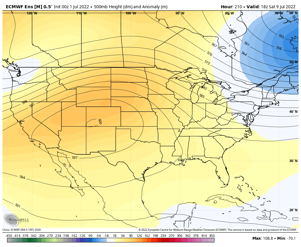
This will give us maybe a day or two of increased rain chances Wednesday and Thursday, but probably no better than 30 percent or so. Otherwise, look for mid to upper-90s to persist, and perhaps drier weather into the weekend. Seeing a 600 decameter ridge on the map above is really impressive for a 50 member ensemble mean. This means that the model is highly confident in a very strong heat pattern for the interior West, likely expanding to include most of Texas heading toward the week of the 11th. It won’t be as hot relative to normal as June saw, but it will still be very, very hot.
June recap
We’ll close with this: June 2022 was the hottest in Houston’s recorded history. Our average temperature in June was 86.7°, which broke 2011’s record by a half degree (86.2°).
It was also the hottest June on record in Galveston by over a full degree. June 2022 saw 87.5° for an average temperature, compared to 86.2° in June 2011. 87.5° for a month is hotter than any July on record as well. In fact, June 2022 will end up being the 4th hottest month of any month on record in Galveston. Of the 60 possible high and warm low temperature records Galveston could have set in June, they set or tied 19 of them, over 30 percent. Galveston’s records extend back to 1874.
A number of factors all play into these records: An extremely warm Gulf of Mexico, the drought, a stagnant weather pattern, urbanization, and, yes, climate change. Hopefully July is better behaved.
Why did the forecast miss so badly?
Tropical systems that stay disorganized are by their nature difficult to forecast. It’s a game of falling dominoes, but you don’t know when and where each domino will fall. Once you do, you’ll figure it out, but that happened yesterday and overnight. We even kept our expectations fairly in check relative to some model guidance too. But it wasn’t enough.
It seems like Houston is just perpetually capped
I think it’s the Pacific tropics SSTs are cold and getting colder. Trade winds or some such nonsense. This keeps jet stream way north so it doesn’t blow the stagnant capping away. The Mexican plateau is hot and dry and just next door too. One can blame climate change but really…does it make the trade winds blow west? If you just stop expecting rain until September you won’t be so disappointed.
Except there is evidence that climate change is becoming a factor in weather changes today. I understand there are people that will never accept CC no matter what scientific data you try to provide to them, but its occuring.
When there is a month with half a degree cooler than normal will that be due to climate change (previously known as global warming)? Seems as if it “causes” everything: more storms, fewer storms, more intense storms, fewer intense storms, hotter, cooler, icy weather, droughts, floods, etc.
Global warming drives climate change. One did not replace the other. Think of global warming as the fuel that runs the climate change machine.
And yes, its effects are far reaching. That’s the nature of increasing heat energy in a global system that can’t distribute it evenly. We could receive a blizzard in Houston next year but that wouldn’t change the fact that overall the heat content of both the land and sea has measurably increased. Consider that since January 2001 Galveston has set or tied 367 daily high temperature records and only 16 daily low temperature records (two of those new cold records were set during the 2021 freeze.) We are seeing record heat far more frequently than record cold.
Matt,
Does the warm air blow off the mexican plateaus west over Houston in the mid levels of the atmosphere? Is that why we have a capping inversion so much?
Why has there been such a persistent high pressure over Texas this late spring, unlike last spring, though it had a la nina as well?
How come the tropical systems that have been forecast to come onshore between Victoria and Beaumont since after Harvey have almost always tracked east of where most of the models the several days before landfall had forecasted them to track?
Sometimes it’s a bust. Originally it was supposed to start Tuesday night, but when it kept getting pushed out each day, I realized it probably wasn’t going to happen.
Hey, Matt. Is the June average temp from IAH?
Would like some specifics on how climate change is involved
Climate on Earth has been changing for approximately 4,543,000 years. In just the past 650,000 years, there have been seven “ice ages”. I doubt any sane human is against conservation of nature and clean air; however, global living standards (families) still rely on fossil fuels for income, food, shelter…survival. The immediate problem is the politicization of climate change and media fear mongering that creates sophomoric reactionaries. A realistic transition to greater conservation of nature will require mass change in human entitlements and behaviors over generations. There is no “quick fix”. Let’s just hope those reactionaries don’t make everyone’s lives miserable in the interim.
Those big changes you speak of didn’t happen overnight, it took tens thousands of years for what is now taking only decades, I guess you won’t have to worry about adapting though. It’s ironic that you and your ilk who downplay climate change harp about politicization when that’s the only thing you’re capable of since science plays no role in your discourse. You speak of being comfortable in your cozy Western lifestyle but too bad you can’t have a little regard for the comfort of future generations who’ll suffer from the selfishness of those who refuse to care.
P.S. you should save your musings of climate change in a time capsule for future generations to mull over. When the earth is much more of a hostile place I’m sure they’ll be so proud of great granddad Richard who felt joy in sticking his head in the sand so he could boast that he was not one of those bad bad ‘reactionaries’.