Good morning. We’re now approaching the half-way point of a multi-day heavy rainfall event that began Sunday and should wrap up on Thursday. We remain at a Stage 2 alert on our flood scale, which means the Houston region is likely to see flash flooding. The bottom line is that this air mass has produced explosive rainfall events the last two days (southwest, and then east of Houston) along the Texas coast, so it bears watching closely.

Tuesday
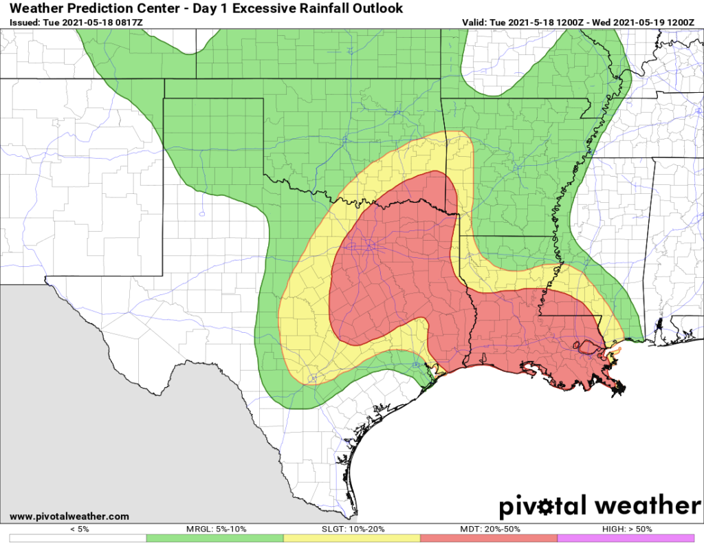
Although we should see showers and thunderstorms in Houston today, they may be less organized than on Monday. The primary threat for widespread, heavy rainfall is likely to lie north and east of the Houston metro area, where the atmosphere remains somewhat more unsettled. This area, north of Montgomery County and east of Harris County, is shown on the “excessive rainfall outlook” prediction below from NOAA for Tuesday and Tuesday night. Unfortunately, the area of “moderate” risk, denoted in red, could affect the Beaumont and Lake Charles areas that were hammered by heavy rainfall on Monday. Highs today will be in the mid-80s, with mostly cloudy skies.
Wednesday and Wednesday night
We continue to believe that the period from Wednesday morning through Thursday morning will bring the heaviest rainfall to most parts of Houston. This is because of vigorous atmospheric lift, and a setup that allows a regenerative flow of moisture from the Gulf of Mexico. During this time frame we think rainfall totals will average 2 to 6 inches across the region. Our main concern, of course, is higher bullseyes that drop in bursts and lead to flooding. This will will definitely be possible given the moist and unstable air mass overhead.
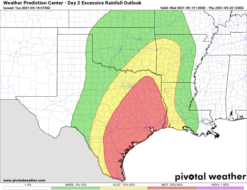
Where will these bullseyes occur? As you can see in the excessive rainfall outlook for Wednesday and Wednesday night, we just don’t have a great handle yet on where the heaviest bursts of rainfall will land along the Texas coast, and points inland. When we have more definitive information to share, we will share it.
Thursday and Friday
Whatever mess develops on Wednesday and Wednesday night will carry over into Thursday morning. Conditions should begin to improve during the afternoon hours, but if you’re looking for a guarantee of that, we can’t provide it. After the worst passes, we should still see on-and-off light to moderate showers to end the work week. However, these should for the most part not produce heavy, flooding rains. Highs will be around 80 degrees both days.
Saturday and Sunday
Saturday should be a lot like Friday, which is to say mostly cloudy with a healthy chance of light to moderate rain. We don’t expect a washout, by any means, but keep an umbrella handy. Some sunshine may break through on Saturday before the sun sets, and Sunday should see clearing skies. Rain chances on Sunday should fall back to around the 10 percent range, and remain low for several days. You’ll be ready for some sunshine, right?
Our next update will come by or before 7pm CT today.
We have my son’s graduation in college station Wednesday @ 1230pm. Should we plan to stay in CSTAT Wednesday night ?
Would be no fun to drive that far with flood conditions all around. The expanse of heavy rain would include the College Station area, as well. It even floods there sometimes under prolonged heavy rain, like what is expected. Congrats to your son!
Thanks will leave tonight can not risk not getting there!
I want to leave some toast out on Sunday, to honor the Toast God, Toasticus. Is it going to rain and soak my toast offering? Toasticus will not be pleased if that happens.
I think you should cancel your flight 😉 .
And your mother should stay home and not travel to your daughter’s birthday party.
And you should cancel your event.
And you will have precisely 3.023514 inches of rain in your back yard.
I think that should cover all questions…..maybe not.
Thank you for your good and accurate information.
This event is just more fuel to the fire of the “why do I live here anymore?” argument I have been having with myself the last 5-6 years.
So move then and stop whining about it on a weather blog. No one cares.
Not that simple.
You live here because most of the year the climate is great, lots to do outside year round, the restaurants and food is outstanding, cost of living is good and we have a football team that you know will always be completely irrelevant so it won’t cause you unnecessary heartbreak.
I think many of us have discovered that the cost of living here is considerably higher than the price advertised.
No state income taxes, and no job-killing red tape!
…weighed against the increased risks of dying in one of our annual “1,000 Year Flood Events” which are exacerbated by poorly-planned urban/suburban real estate development… OR when our unregulated electrical grid collapses and you freeze to death or burn to death while trying to stay warm… OR the increased risk of lung/pancreatic/bowel cancer due to all the petro-chemicals pumped into the air, or dumped into the water, and soil… OR the…
Amen. As soon as my kids graduate we are out of here. And I lived in Seattle for 10 years and never hated the rain until we moved here!
Man, it’s a problem when you can’t even come to a weather site without people being snarky with each other…
Do not let this all distract you from the fact that Lupe Tortillas has the best beef fajitas in the world. 🙂
My wife and I are just glad we’re retired and don’t have to drive on the freeways during the “jam hours” (AKA AM and PM work commutes) caused by rain.
I am in Austin now but used to live in Houston and my clients are there. I really like your customized flood scale with reference to historic flooding events.