If you’re suffering from weather whiplash in the Houston area, I can’t say I blame you. It’s been a rocky month so far, with a lot of big swings in temperature.
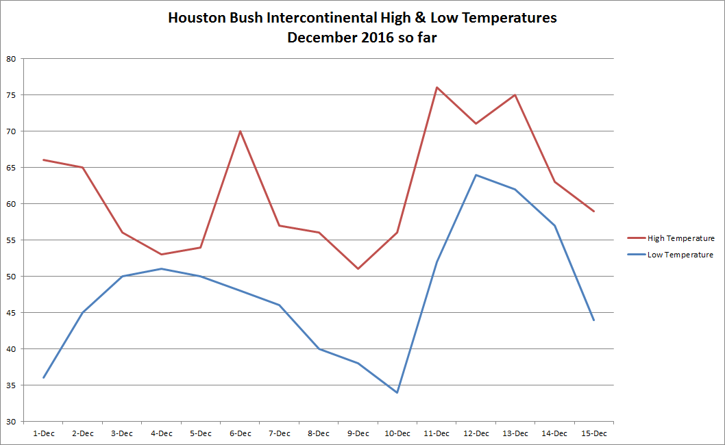
We’re back on the way up today, charting a course that will translate into a wild swing in temperature Sunday.
Today & Saturday
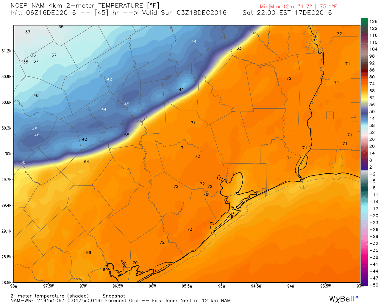
The changes are already underway, as we have begun to slowly pump in humidity off the Gulf this morning. Expect a lot of cloud cover today, and don’t be shocked if you see a few raindrops also in the form of light rain, showers, or drizzle. We’ll peak in the upper 60s to low 70s this afternoon, and as we go into tonight, temperatures may hold steady or continue to slowly rise. In fact into tomorrow, it still looks as though we could push 80°, which would tie the record high for the date set in 1908, 1984, and 1990. December’s all-time record of 85° set on 12/3/1995 should be safe. That said, some model guidance is suggesting we could hit as warm as 83-84° tomorrow; summer-lite for sure.
Saturday’s weather should feature a lot of clouds and a chance for a few showers here or there. The other issue Saturday, especially in the morning and evening, will be dense fog along the coast and bays.
Saturday Night-Sunday Night
The main event occurs around midnight Saturday night, as our cold front, a true blue norther, blows through the region. Our high temperature Sunday will likely be at midnight, and once the front passes, temperatures will quickly fall from near 70° or in the lower 70s to near 50° or colder (probably within 15-30 minutes of the frontal passage). Winds will begin to howl out of the north, gusting to around 30 mph inland and perhaps 35-40 mph at the coast. Showers are likely with the front and there may be a rumble of thunder, but no severe weather is expected at this time.
There is a growing chance that areas north and well west of Houston will experience a freeze on Sunday morning. At this point it looks to be mostly places like Columbus, Huntsville, Conroe, College Station, and Livingston that are at greatest risk. Sunday will end up being a raw day. Temperatures will warm up a bit from the morning, but don’t expect anything beyond the mid 40s for highs. Add in wind, and wind chills in the 20s or teens are likely.
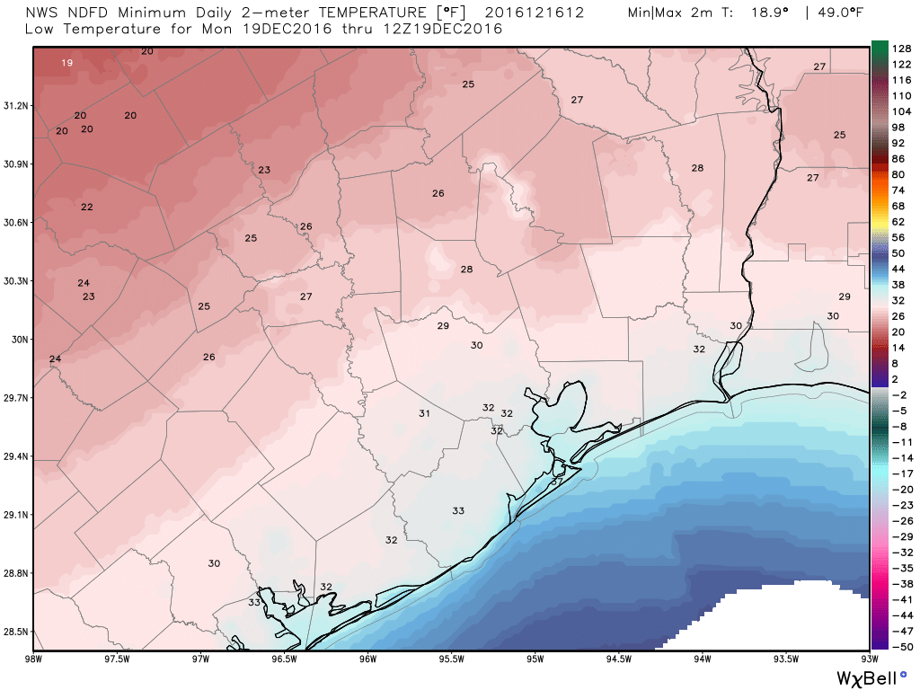
Sunday night remains an open question as to how cold it gets. Unlike the last real cold morning we had on December 10th, models have trended colder leading into this event. Temperatures will likely approach the freezing mark north of I-10 and even in rural spots south of I-10. The official low in Houston will be close to freezing, but much of the city will probably stay around 33-35° on Monday morning. We’ll keep you posted this weekend.
Next Week through Christmas
We’ve got no big changes to what Eric’s been discussing this week. Expect a gradual warming trend after a chilly Monday. Tuesday and Wednesday will see sun and clouds. Temperatures will range from the low to mid 50s Tuesday to the low to mid 60s Wednesday. Another weak front looks like it will move through Wednesday, bringing us cooler weather Thursday and Friday (though not to Sunday and Monday’s levels). That should set the stage for a warm up into Christmas, and I think Eric’s call of upper 60s and a minor rain chance (perhaps a cold front?) still looks good today. We will keep you posted, but the weather whiplash continues!
Posted at 6:45 AM by Matt
So we shoukd bring a light rain jacket to the day for night festival on Saturday?
You won’t need it during the early evening, but if the front comes through a little early, it could drop from 75 to 45 before the festival ends.
Certainly a wintery change! Checked with family in western WI who report temps in single digits, wind chill below 0, forecasted wind chills 20-30° BELOW zero and blowing snow of 10 inches. How well I remember those years. Our Sunday weather will be balmy in comparison.
I realize that everyone at NWS is trying their hardest, but the forecast of this event was off.
At 2:39PM Saturday the NWS freeze warning did not include Houston; the freeze line was from “Columbus to Tomball to Livingston.” There was no wind advisory for the central forecast area, including Houston, for Sunday; in fact the statement said “Hazardous weather is not expected at this time.)
At 7:52PM Saturday the freeze warning was extended south to include Houston, and a wind advisory was issued for midnight for Harris and nearby counties (although the strongest winds at my house in Champions were around 10PM).
Strangely, the wind advisory that had been issued earlier in the day for Grimes and Montgomery counties was cancelled at 7:52PM. Statement: “Winds over these counties are not expected to achieve Wind Advisory criteria of sustained 25 mph.” Well, that statement had already proved false. Perhaps they should reissue the advisory.