As anticipated, it’s warm and breezy across Houston today with high temperatures reaching about 80 degrees as of noon. Brisk, southerly winds are gusting in from the south at up to 30 mph along the coast. Change, of course, is coming soon. We’ve been talking about a strong cold front arriving on Saturday night, and it as strong—if not stronger—than advertised.
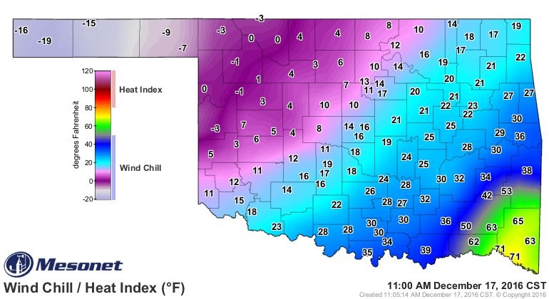
The graphic below shows the swing in wind chill temperatures before, along and behind the front as of 11am CT in Oklahoma this morning. This represents a 90-degree swing in temperatures from the Oklahoma Panhandle to the southeastern corner of the state.
Texas faces the same thing tonight and on Sunday. Right now it appears as though the cold front will reach far northern parts of the metro area, including College Station, by around 9pm or so, and move into Montgomery County and northern parts of the city of Houston by or around midnight. High-resolution models show it moving off the coast by around 3am on Sunday morning. Some light to moderate rain showers are possible as the front moves through Houston, but I don’t expect accumulations of more than a tenth of an inch, or two. Temperatures will fall swiftly.
The front will arrive early enough on Saturday night to potentially bring a freeze to areas of College Station and Montgomery County on Sunday morning, but I expect the vast majority of the metro region to stay in the mid- to upper-30s. However with brisk, northerly winds on Sunday morning we’ll be waking up to wind chills in the upper 20s, so it will feel really cold outside. As skies clear on Sunday high temperatures will “climb” into the 40s, but with a brisk northerly wind it will still feel very cold.
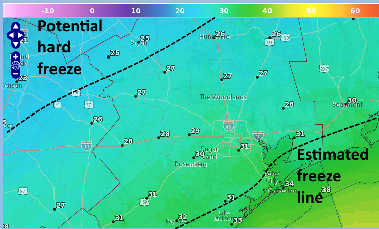
Sunday night is when the region’s best chance for a freeze this season will come. It remains difficult to parse exact temperatures for Monday morning, but night now it appears that most of the Houston region will be at, or below freezing temperatures. Some guidance has areas like College Station in the low- to mid-20s. In any case, here’s an estimate of a potential freeze, and hard freeze locations for Monday morning.
Temperatures should warm enough that most of the city of Houston won’t see a freeze on Monday night, but don’t expect high temperatures to rise much above the lower 60s for most of next week.
The forecast for Christmas Day itself remains somewhat in question, with the next strong cold front due sometime in a week or so. The front could come just before Christmas, on the holiday, or just after Christmas. We’ll also have to watch for the potential for rainfall to accompany the front, which could make for a soggy holiday. Time will tell—for now locate those sweaters and take precautions to protect those plants on Monday morning.
Posted at 12:30pm CT on Saturday by Eric
So, not quite a “triple P” night for Ellington/Clear Lake Monday night?
Just bring in the pets and potted plants?
Our first one in a year or two. Don’t worry, WE WILL REBUILD!
I’m not guaranteeing a freeze for Clear Lake. I think it will be close. But yes, potted plants should be brought in.
While “it’s beginning to LOOK like Christmas” i.e. snow, isn’t happening, but it sure will FEEL like Christmas! (at the North Pole)
Great chart showing the wind chill swing in Oklahoma.
Guess I won’t be wearing my new Space City t-shirt anytime soon ?
Haven’t gotten ours yet!
When was the last time the city of Houston had a hard freeze? I don’t recall freeze last winter and the hibiscus and banana plants seem to indicate we didn’t have one. I also see a fair number of large giant birds of paradise and even the occasional foxtail palm which I don’t think survive hard freezes.
January of 2014.
http://forecast.weather.gov/product.php?site=NWS&issuedby=IAH&product=CF6&format=CI&version=37&glossary=0
How strong will the winds be in the Houston area, Eric? 40 mph? 50mph? (Anybody wanna try for 60 mph?)
20-30 mph most likely, with a brief period of gusts up to 40 mph.