Autumn is often a time for weather forecast headaches. We’re wasting no time this season, with our first legitimate cold front of the season knocking on the door next week, though there’s a good chance the door won’t open. Let’s talk details.
Today & Saturday
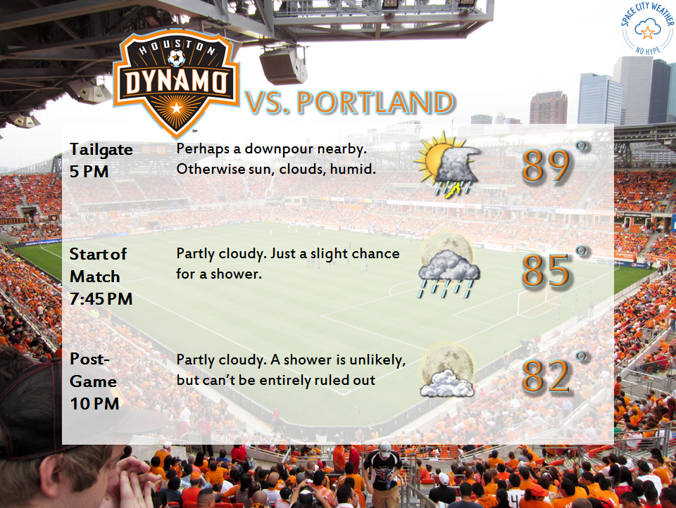
First, the “easy” part of the forecast. Summer-lite continues the next couple days. We’ll see some showers and perhaps some thunderstorms off the Gulf each morning and afternoon. These will be of the typical Southeast Texas scattered and hit/miss variety. If you have outdoor plans the next couple evenings, go ahead with them, but just know there may be a downpour or two to contend with.

Temperatures will remain on the warmer side. Expect highs near 90 or in the low 90s. Overnight lows will remain miserably warm, in the mid to upper 70s inland to near 80 at the coast.
Cold Front Update
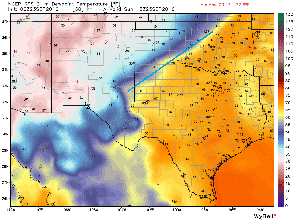
Alright, let’s talk cold front. On Sunday afternoon, the models are in good agreement that the front will be exiting the Panhandle region on its way to Central Texas. A simple way to see this is by looking at dewpoints.

Ahead of it, expect plenty of humidity and mid to upper 80s, along with scattered showers and thunderstorms. I don’t think Sunday is a washout for us, but there will almost certainly be some downpours to contend with across the region. From this point on, the models get messy almost to the point of being useless. I see three reasonable scenarios that could play out here.
Scenario A: “I promise to never let go.” – Summer. This is what yesterday afternoon’s European model liked. Basically, the front gets to maybe I-35 and then stops forward progress. This means continued high humidity, temps in the upper 80s to near 90 (AM lows in the mid to upper 70s still), and daily scattered thunderstorm chances into much of next week, but only locally heavy rain. This would probably the option most of us hate.
Scenario B: “You will try…” In this scenario (which would a hybrid split between the GFS and Euro), you’d end up with the front getting to Eastern Texas or near Houston and then stalling. This would mean cooler temperatures, but not quite like autumn; perhaps something like low 80s during the day and low 70s at night. We’d still have plenty of humidity, and we’d have repeated chances of showers and thunderstorms daily next week. This wouldn’t be particularly ideal, but at least it would be a bit cooler, right?
Scenario C: “The end of summer….for now.” This is what I think most of us are rooting for. The front sweeps through Houston Monday sometime, and we end up refreshed, with drier air and comfortable temperatures early next week. Rain would be in a band Sunday night and Monday as the front moved through, would add up to an inch or so maybe, and then be on its way. Autumn bliss, at least for a few days.

All that said, while I want terribly to give Scenario C and a couple days of autumn the best chance here, I cannot. I’m not an odds-maker, but if I had to assign percentages to the 3 scenarios outlined above, I would currently give A about a 40% chance, B a 40% chance, and C a 20% chance. I just can’t get optimistic about this front given the latest model data.
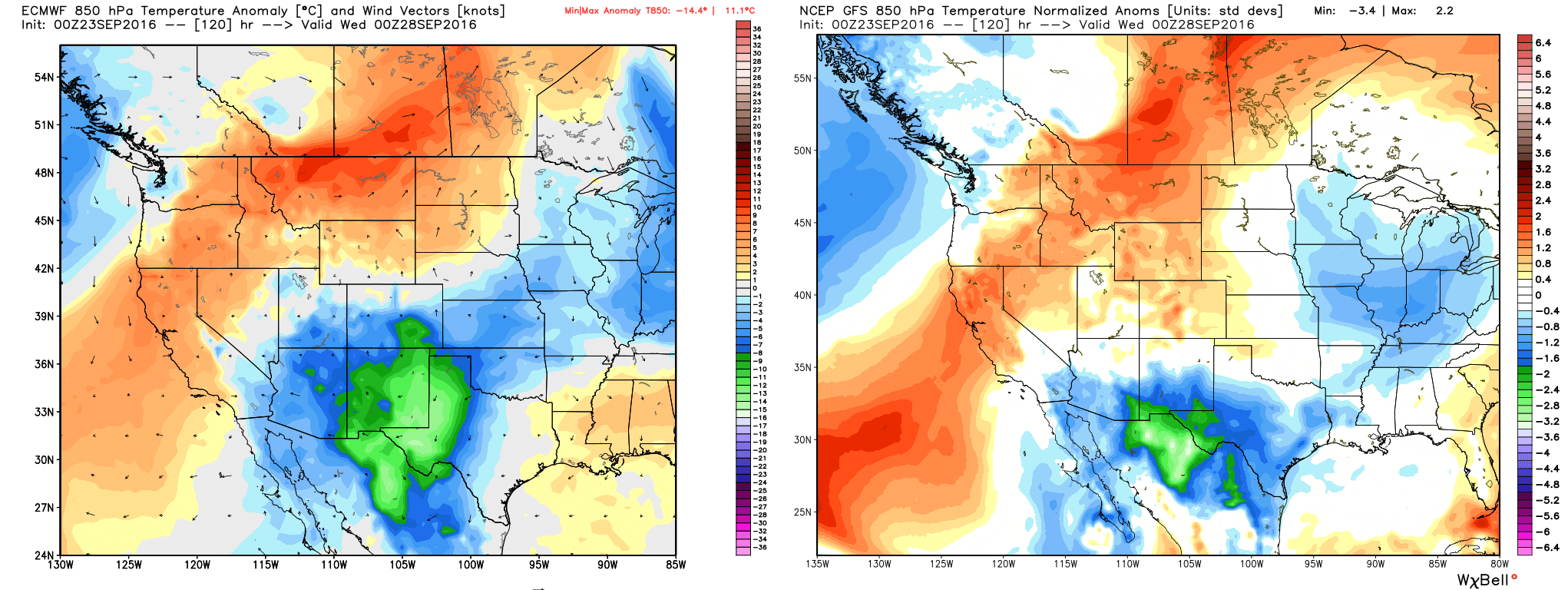
The European model throws an interesting curve ball though. It basically stalls and weakens the front to our west, so it never gets through Houston. However, by Thursday, it brings a weak front in from Louisiana, which would serve to knock down the humidity but not cool us off much. Something to watch.
At this point, I’d expect slightly unsettled weather much of next week, with highs in the mid 80s and lows in the mid 70s. As you can see, there are still options out there, so this forecast could very well change over the weekend. We’ll stay on top of it for you and update you tomorrow or Sunday on the latest.
Posted Friday at 6:45 AM by Matt
Thanks for the thorough explanation…..I appreciate it.
Random question Matt:
Why do dew points (and therefore overnight lows) tend to be lower in the Pineywoods than in the Brazos River Valley?
I don’t know for sure, but I would speculate it’s topography and geography. Again, not certain on this, but based on experience I’d explain it something like this: I think the Piney Woods are pretty sheltered, so they see less impact from the Gulf. There are so many trees there that there’s a natural cooling mechanism or “sink” to absorb Gulf moisture a little more. The Brazos Valley has fewer trees or at least less density of trees, so moisture is able to spread out more and has less to absorb the moisture. It could also have something to do with development. The Brazos is a relatively developed river valley, so more urban/suburban area and farmland, whereas the Piney Woods are pretty rural and not as developed or farmed out. That alone will help keep them cool.
Where I’m originally from (NJ), we have the Pinelands in the interior part of the southern half of the state…a lot of similarities to the Piney Woods. Temperatures at night there can sometimes be 10 degrees cooler than the Coastal Plain or suburban areas closer to NYC and Philly. Trees/forest can make a *huge* difference on local climate.
Are you aware of the 12Z GFS run that brings a tropical cyclone to deep south Texas on Oct. 9, Matt? What are your thoughts on that?
Well aware of it. I chose to intentionally not discuss the tropics in today’s post. For one, the GFS has a long, storied history of poor forecasts beyond days 5-7 with tropical systems, so a forecast on days 13-15 has absolutely 0 credibility. Second, if you look “under the hood” at the GFS Ensemble (which runs the GFS about 20 different times with different initial conditions), you see absolutely no consistency on what develops and where it ends up. The spread in potential geographic outcomes ranges from Central America to the Gulf to out to sea. Third, the European model and ensembles, which are more reliable, are much more lukewarm about this system’s ultimate end game.
A lot can happen, but right now the GFS is struggling with a day 5 forecast over the US. I’m certainly not putting stock in it on day 15 with a tropical system. We’ll want to watch, but 0 clue where it goes and what it is when it gets there right now.
What about the chance for a low to develop off the tail end of this front and (possibly) flood all of Texas, Houston included? Do you know about that, Matt?
Currently, I am storing my bright colored summer togs and fluffing up sweaters on hangers! My hope is for need to put away all summer…..still, I am prudently leaving warm weather clothes out ….flexible!!! Thanks for your explanation! I choose C!
There are a couple of storms out in the Atlantic (Karl & Lisa). In looking at their forecast paths, is there any chance they could collide in the northern Atlantic???
Sounds kind of cool, but unfortunately it shouldn’t happen ha. Lisa’s weakening as we speak, and Karl should begin to accelerate out to sea shortly. Lisa’s remnants should stay trapped out in the Atlantic and will get picked up eventually. But Karl should be long gone in a couple days!
what would keep the cold front from coming through the area in the first place, Matt? High pressure to the east of Houston?
Yeah. Sometimes these things don’t have enough “oomph” behind them, and they end up getting hung up over us or to our west or north. In this case, the system dragging the front “cuts off” from the jet stream over the Plains and Upper Midwest. Those cut offs are difficult to forecast, and the front is sort of at the mercy of what happens there. So it makes it complicated for us.
Incidentally, AM model data is more positive regarding the front getting through. Fingers crossed.
Trouble is, Matt, there’s a chance for some serious flooding and heavy rains if/when the front comes through. If the lift from the Gulf is sufficient, this system might yield flooding-type rains not unlike Iowa is presently experiencing. I’m sorry, but it looks like there’s going to be a dark (hint, hint hint) side to this.
It’s nice to know that Scenario C is the one that has ended up happening!
Yes!