Yesterday was Houston’s hottest day since May 20th. We hit 94° on Thursday, and that’s a preview of things to come. We have no real changes in our expectations that Cristobal (now a depression) will miss to our east. The main impact from Cristobal in Houston will be heat, thanks to drier air on the western fringe of the storm.
Today
Expect a quiet Friday overall. We’ll start with some patchy low clouds or fog in spots but transition to partly to mostly sunny skies this afternoon. Highs will be in the low-90s for Houston, cooler at the coast and hotter inland. Yes, a few showers or slow moving downpours could again flare up with daytime heating, but we expect most of the area to stay dry.
Saturday
Rinse and repeat. Cristobal will still be well off to our southeast at this time, and we should see mostly a repeat of Friday’s relatively nice (albeit hot) summer weather. Perhaps one or two will see a cooling downpour, but most will not. Highs will again average in the low- to mid-90s.
Sunday
As long as Cristobal keeps tracking toward central or western Louisiana as expected, that would likely mean a dry and hot day on Sunday. Expect mid-90s.
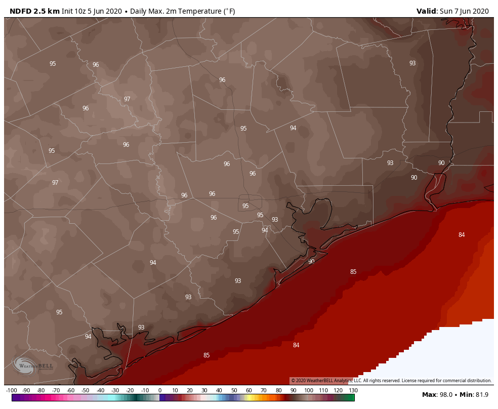
I try to view things as optimistically as possible, so I’ll just add here that while Sunday will likely be hot, it will be a little less humid than we have been of late. So we’ve got that going for us, which is nice.
Showers on Sunday? Probably not many. Part of Cristobal’s cloud canopy could be noticeable east of I-45, which could mute temperatures a little in those areas. But rain would probably stay in Louisiana on Sunday.

Monday
This will depend entirely on what Cristobal does, but assuming the storm’s center lifts into northern Louisiana, we would again be mostly hot. A few showers or a gusty storm would be possible here, mostly east of Houston. Look for generally mid-90s once again.
Rest of next week
I’ll level with you here. I’ve been watching the extended forecast the last couple days with a bit of curiosity. We’ve been pretty focused on Cristobal and any potential impacts from that. But quietly, the forecast for later next week has gotten intriguing. Tuesday will likely be blazing hot and humid, with temperatures testing the upper-90s, if not 100 degrees in spots.
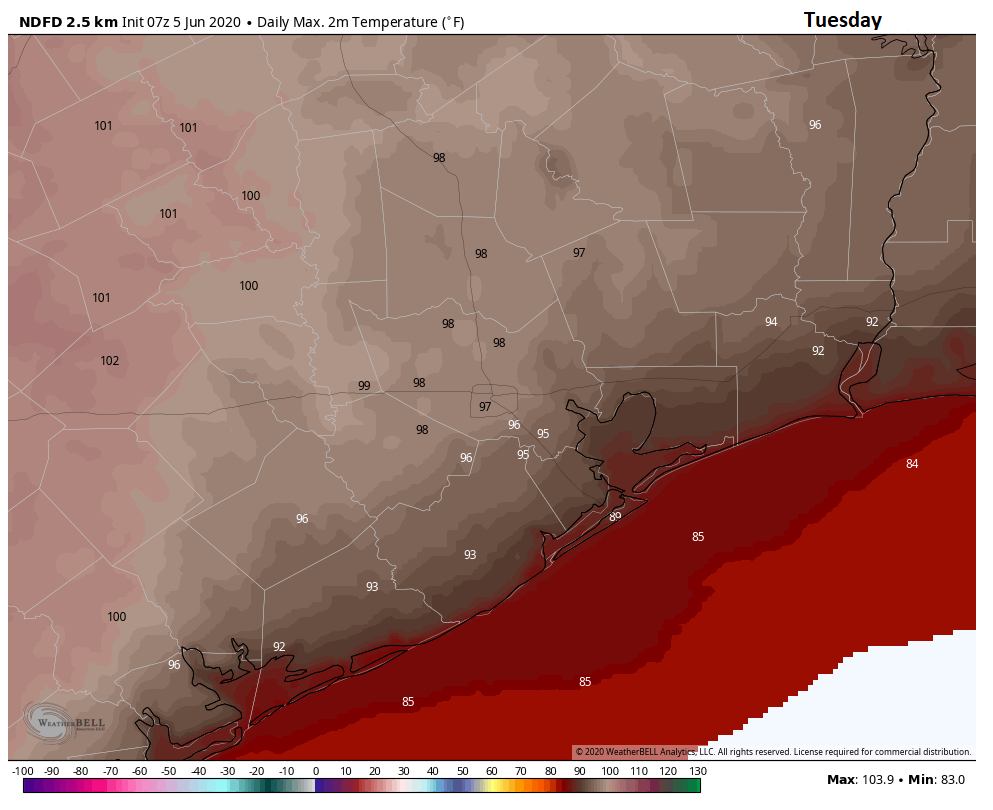
Wednesday will be similar.
But there are a lot of hints in modeling right now that a bonafide cold front is going to push through Southeast Texas on Wednesday. It’s important to know what a June cold front means versus, say, one in February or March. You would notice continued hot daytimes, but nothing like Tuesday and Wednesday. We’d likely see highs in the low-90s or mid-90s. Nothing cool about that. But you would notice substantially lower humidity. Evenings or mornings may be considered refreshing. Low temperatures would edge back into the 60s. In other words: Not typical Houston summer weather.
We can see the front simply by looking at levels of atmospheric moisture (precipitable water, or PWAT). Here is the European ensemble and its 51 members. Most of them are projecting a steep drop in available moisture from late Wednesday through Saturday.
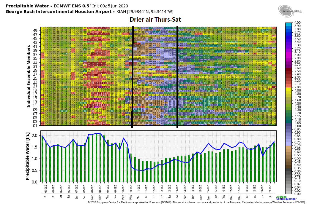
Right now, we would probably give this scenario like a 60% chance of occurring? It seems likely we are going to cool down a bit regardless for later next week, but exactly how much cooler and less humid, we’ll see. I’m fairly optimistic though. Fingers crossed for some changes.
More on Cristobal
Just a quick update on Cristobal. The center has begun to turn to the north this morning over the Yucatan. That will continue this weekend. There has been a little back and forth within modeling since yesterday, but virtually all data continues to point to a track northward, with a bend to the northwest as it approaches the Louisiana coast. Cristobal likely makes land somewhere between Cameron and Grand Isle, LA on Sunday night or early Monday.
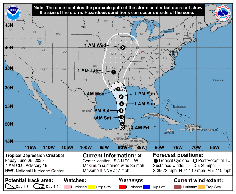
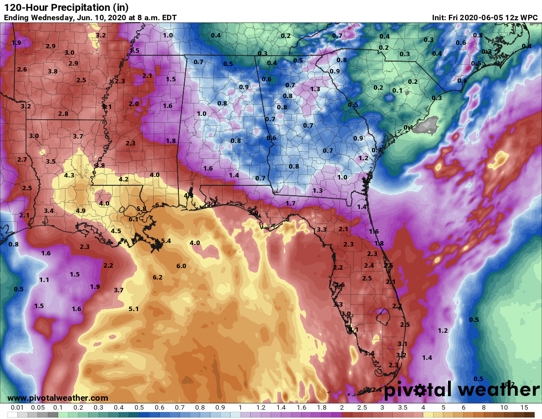
The intensity is always a bit more challenging, but Cristobal, while beat up over land in Mexico, is going to emerge with its center intact, albeit a good bit lopsided (with impacts skewed far, far to the east of the center). Given the size and lopsidedness, Cristobal will slowly, steadily strengthen, so it will likely only get up to moderate tropical storm strength before finding land again. That said, the storm will be loaded with moisture, and rainfall amounts of 4 to 8 inches or more should fall along and east of where the center tracks, with flash flooding possible.
We’ll keep you posted through the weekend if anything should change.
“So we’ve got that going for us, which is nice”. Way to quote Carl! Made me laugh this early in the morning. Well done. (And thanks for the hype-free Cristobal forecasting. Houston is so grateful for you both.)
Big hitter, the Lama.
So basically, June cold front = California summer weather
No, not even that good. But still very good for us.
Although I keep my “No Hype” umbrella handy every Sunday at Bay Area Farmers Market, I am relieved that I will not likely need it this Sunday, with Cristobal’s rain staying east of us. The farmers market’s other nemesis (besides the given, Texas heat), particularly in the bay area, is the wind. Should we expect the wind to increase considerably on the west side of Cristobal?
As we “breeze” through the market Sunday, I expect it will a good day to wear our “No Hype” t-shirts! Thank you so much!
Thanks for your support! Winds probably won’t be up too much on Sunday. Probably 10-15 mph or so, maybe a higher gust here or there, but nothing too bad in all likelihood!
No – thank you! As a beekeeper and farmers market owner, I lean on you heavily, day by day, and week by week! Soooo grateful for you!
At first, today’s report was not very upbeat with the “high heat/humidity” prediction. But, that mid-point part about a bonafide cold front, which would bring DRY air, brought a smile to my face.
I’ll take hot as long as its dry (or drier). Walking outside and feeling like a hot wet blanket is around you is not optimal. Yet, as a lifelong Houstonian, I still don’t like it. But, I’m still hopeful that the dry front will come.
Gunga galunga.
You beat me to it, well played.
Are there any records of moisture levels in the air? I feel like we’ve been having drier summers than we used to, situations like the one which could come about late next week, which I never remember having before (during the summer at least, say June to September).
This upcoming event may challenge some daily records for low precipitable water (https://www.spc.noaa.gov/exper/soundingclimo/), but it’s tough to say for Houston, since our closest sounding that calculates PWAT is in Lake Charles. The last two summers have had some fronts sneak in at times, but if anything atmospheric moisture levels have been higher more often than they’ve been low. I know we’ve frequently challenged some daily high-end records. But for summer specifically, maybe not.
Is there a site similar to yours if I’m located in Baton Rouge, LA? Lived in Houston in Harvey and relied heavily on your site during that season. Thank you!
“So we’ve got that going for us, which is nice.”
Amazing.