Good morning. Alas, our forecast remains largely unchanged. High pressure is dominant today. High pressure will be dominant tomorrow. And that persistent ridge is going to remain into place at least through early next week and very likely beyond. This means a couple of things:
- First of all, please continue to practice heat safety. It is hot, hot, hot during the midday hours and you should know the signs of heat related illnesses.
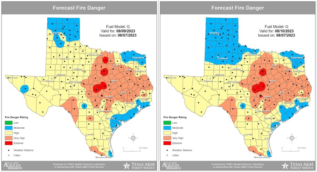
- Secondly, we’re continuing to see high to very high fire danger conditions across much of the Houston region, especially for Montgomery County and areas further inland. The state has seen dozens of wildfires recently, and the number is on the uptick.
Also, I want to mention again that we’ve released an updated version of the Space City Weather app for mobile phones and tablets, and it is one we’re really proud of because it brings a lot of the features you’ve requested. It’s also the one way to ensure that you never miss a post during inclement weather. Which, presumably, we’ll have one day again in the future. You can find the app in both Apple’s App Store and the Google Play Store.
Tuesday
At this point, do I really need to write it out? It feels like we’re in the movie Groundhog Day. Highs today will be around 100 degrees, or slightly above. Skies will be mostly sunny. Winds will be out of the south, at about 10 mph, picking up a bit during the evening and overnight hours. Rain chances are 5 to 10 percent. Low temperatures tonight will drop into the low 80s.
Wednesday through Friday
Absolutely no change.
Saturday and Sunday
It’s still difficult to discern a meaningful change in the sensible weather.
Next week
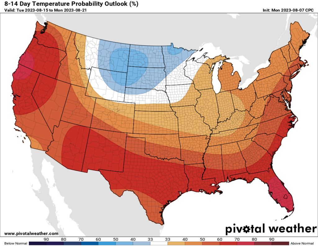
I’ve saved the bad news for last. Whereas a couple of days ago we had some hope that this persistent high-pressure pattern may break down somewhat as we got toward the middle of August, at this point I’m just not seeing it. Sure, we might see some rain chances return by Tuesday or Wednesday of next week. But the odds of meaningful rainfall at this point remain low. And temperatures still look blazing hot for the foreseeable future.


Insert Chronicles of Riddick incineration gif here
I’m waiting for you guys to pull a fast one and copy and paste an entire day’s entry into the next day. No one would be able to dispute it.
At this point I’ll take the “broil” that in my meteorologically inept mind I associate with stiff arming hurricanes away from the Gulf. I would like, however, to be cryogenically frozen until October 1.
Extend my cryogenic slumber until November 1. October in Houston still has 90+ degree days.
Exactly! I second that! This heat makes me want to hibernate for the remainder of the season, but it most definitely beats the ‘unwanted friend’ that calls itself a hurricane, let alone any chaotic storm. I do understand that farmers and those in agriculture require moisture, and I sincerely hope they receive it, but not an overabundance of aquatic chaos.
Yeah, I gotta agree with Joel — I’ll take the high pressure heat, as long as I can also be assured that the high pressure will steer any hurricanes away. Also yes, please freeze me until October.
Nooooooooooooooo
I want a hurricane
Heat kills more people than hurricanes.
The good news is relief is forecasted on some weather sites on the 22nd!
The bad news is that’s 14 days out and that’s as likely as snow this year.
Aaaaand it’s gone…
The playground is going to literally melt as school gets back in the swing!
HA! That was a brilliant unintentional pun! School gets back in the SWING! 🙂
If you don’t like the weather in Texas, wait five months, and it’ll change.
Summer 2011 may very well have its championship belt taken away by ’23.
El Niño is still for forecasted to be feisty this year. Cool cloudy football weather may make us forget about this abomination of a summer.
Cool, cloudy football weather? Where exactly are you? It’s usually quite warm and humid all of the way through football season here (assuming you’re talking about HS).
Typically El Niño Autumms n winters here bring frequent cold fronts and misty weather, Seattle or London style.
Please Tim, don’t kill my pipe dream,lol.
I moved here (mistakenly) from the Puget Sound area. I know of what you speak and very much miss it. I will hope for the same, though I am less optimistic that this particular version of El Nino will impact our “autumn” much. I hope to be wrong, as does the soil, vegetation, and wildlife.
I am having some problems with the updated app. Currently the app is telling me that it’s July 26, that the current heat index is 105° (it’s 8am and other weather apps are saying heat index 94°), and most concerningly that both sunrise and sunset will be at 12am. I’ve tried refreshing and fully closing and reopening the app with no change.
“When you’re at the end of your rope, tie a knot and hold on.” — Theodore Roosevelt
Not a whole lot of good news in todays post so Glenn is back with his semi-daily dose of hope taken from the history of Houston weather. On August 27th, 29th and 30th, 2015 the low at IAH dropped to 69 degrees. In comparison to this summer that is “sweater weather”. Until then take it from Mr. Roosevelt and hold on!
Better to not live in the past Glenn
New kid in class question: On the new App — what exactly am I seeing on the radar on the home page? Is it cloud cover? Thanks.
(PS: I know how to link to traditional radar.)
Everyday I wake up and check to see if there is a day in the 90s (I’ll take 99). Everyday I am disappointed again.
Well, you can skip it for, at least, ten days down the road. Even the extendeds now are relinquishing what appeared to be a “softening” of the high, which may have helped produce highs “only” in the upper 90s.
The Kobra Kai Death Ridge.
No Mercy.
The good news with all of this is that we will have Zero chance of being hit by a Hurricane while the High Pressure / Heat Dome sits on top of us.
Exactly! Silver lining on a silver flame!
Except there was barely little activity in the tropics so far due to other factors not related to the high pressure.
So I have to ask… who writes the posts on the “NWS feed” in the app? Especially the one today. It was quite “punny”
What are the chances this Summer fully overtakes 2011? I’m having flashbacks
It looks like the 2011 rematch I’m afraid.
I have lived in Houston since 2017 and although the summers have always been worse than anything I experienced in NC growing up, this has been on an entirely different level. Even my wife, who is usually quite heat resistant, told me the heat is getting to her.
Why is this heat dome so resilient? We don’t always have a heat dome all summer, every summer, right? I’m just curious why this is happening from a meteorological standpoint and what is lacking/not happening that needs to happen to break it down? Is this all El Nino related? Or should we expect this sort of intensity moving forward? Or is it just bad luck?
We are heading to Anna Maria Island at the end of this week for vacation and I am so looking forward to a week of highs in the low 90’s, as opposed to low 100’s.
We’re having really bad luck when it comes to seeing something trying to break this ridge on the horizon. No sagging fronts, disturbances never making it to the gulf or being blocked, and troughs being hope when they are 10 days out or so then dissapointingly never making it down here (like we saw a few days ago). And yes, El Niño is spicing all this up, an example which is the lull in this hurricane season so far.
It’s always hot in Houston in August. Normal being 96 for a high and 76 for a low. The current heat wave is excessive even for us when compared to normal.
Recently, the heat index at 5 a.m. (when I head out to run) has been 92-93 deg F. This is very much NOT normal.
Agreed. As a morning runner myself, I do not usually melt before the crack of dawn.
It’s climate change. Unfortunately this is most likely the new normal. Especially when we fail to take care of the planet.
It feels much drier today even though the dew points are saying otherwise.