Until the remnants of Tropical Storm Harvey are no longer a threat to Texas, we’ll be posting multiple times a day on this site to provide the best available information. Unfortunately, after looking at the latest model data we continue to be concerned about the potential for this tropical system to bring heavy rains to the Texas coast and some inland areas this weekend, and early next week.
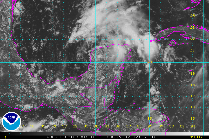
As of Tuesday afternoon, the remnants of Harvey are crossing the Yucatan Peninsula, and it appears almost certain that the storm will re-form over the southern Gulf of Mexico during the next 24 to 48 hours.
The forecast models suggest the storm will then move toward the northwest, and come ashore somewhere on Friday(ish) between Brownsville, at the southern end of Texas, and Freeport, which is just down the coast from Galveston. This afternoon, NOAA’s G-IV Hurricane Hunter Jet will fly around the remnants of Harvey, and this should provide useful information that will improve forecast model output tonight, and especially on Wednesday. But frankly, our biggest concern is not where undead Harvey makes landfall (rain, not winds, are most likely the primary threat here), but rather what happens after the storm moves inland. This is because the upper-air pattern later this week and weekend is such that there will be little to steer the movement of the system, and therefore it may wobble around. When you have a tropical system near the warm, moist Gulf of Mexico, this is a bad thing because it means rainfall. Potentially a lot of rainfall.

A ramblin’ man
For example, here’s a plot I made of the tropical low locations forecast by the 12z GFS model, which brings a tropical storm near the Texas coast on Friday. And then, well, here you go:
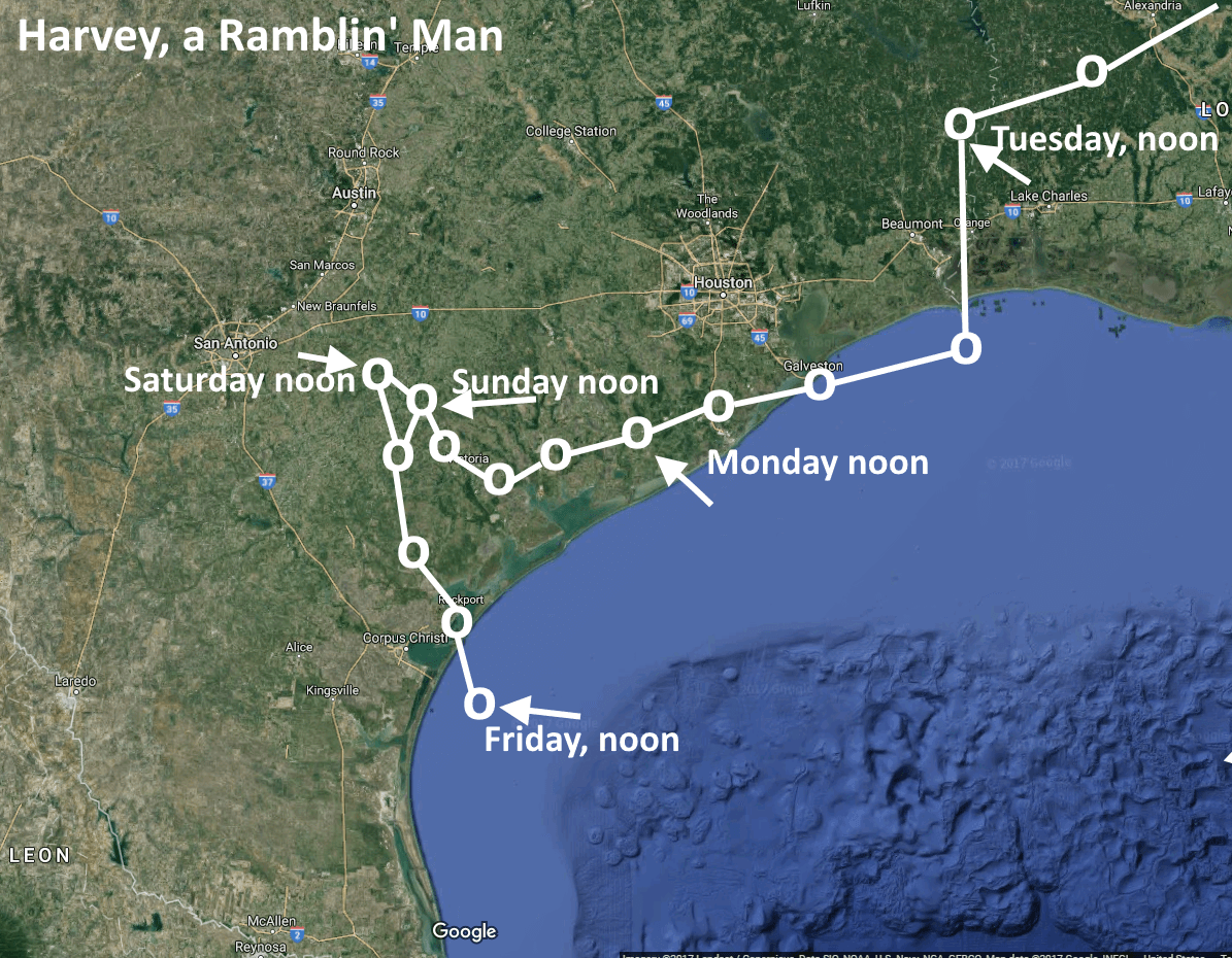
I post this not because you should take the track above as gospel—it is far from it. Rather, the model is illustrative of the fact that this is a tropical system that could very well move inland into Texas somewhere along the coast, more or less stall, and drop 10 to 15 inches of rain (or more) on someone’s head over a two or three day period. Widespread areas may see 4 to 8 inches. I’m not saying this is a repeat of Tropical Storm Allison, as that would be irresponsible. But these kinds of slow moving systems are the ones that often produce widespread flooding.
The next question is, where will the heaviest rainfall occur? Frankly, there is no good answer to that right now. The data gathered by the Hurricane Hunter today will help, so hopefully by Wednesday we should have a slightly better idea. For example, a landfall near Brownsville would be a lot better for Houston than one near Corpus Christi.
What you should know now is that there is the potential for a major rainfall event in Texas this weekend, including possibly the Houston area. Most likely, this will occur sometime on Saturday, Sunday, or Monday. Secondarily, we will be concerned about storm surge and winds if Harvey becomes a strong tropical storm or modest hurricane, but those seem lesser threats at this time.
More, when we know it.
As succinct as ever, without alarm. Just the information we need. Keeping an eye out and watching for your updates.
Thanks Janette.
Eric,
I am so thankful you are on top of this and it puts my mind at ease that u are NO HYPE AND JUST THE FACTS SO I will check my email faithfully to know what I need to do
You’re welcome Rebecca!
Agreed, Janette. Love getting these updates because it’s all about fact, not selective forecasting based on ratings.
Fayette County can’t get a break. 0.52″ in a month or so and now whatever ridiculous amount this will drop in a weekend. Stock tanks need it but …
Probably not the best weekend for a beach trip on Bolivar Peninsula… thanks for the update.
Great information as always. Will be interesting to see how this develops.
Thank you Eric. I just was able to calm my dear Fulgencio through the eclipse and now that is believes the sun is really back I will now have to comfort him to not worry about potential floods yet. We eagerly await your next report!
This Fulgencio you speak of should invest in some medicated bitters or calming tonic for his jitters.
Some tropical rain as we near the height of hurricane season. Who “woulda thunk?”
Thanks for the no drama update.
It’s better to be in the Cone of Death, er, uh – Cone of Uncertainty – early on rather than just before landfall.
I appreciate your work Eric. Thanks. I’ll stay home from planned trip to Corpus Christi and hunker down here in Houston.
Probably a good move, at this point. If you can wait a day to evaulate, I would, on the off chance it completely falls apart of makes a westward beeline.
I love the absence of doom-casting here – its tiring to hear ridiculous “sky is falling” statements from coworkers and Channel 9 when a storm is more than 48 hours out and the track still has huge error bars on it.
I did a safety moment today that was “don’t get scared, just start paying attention” about this storm – Thanks Eric
You’re quite welcome Jason!
What do you mean by “Modest Hurricane?” Eric? Something on the order of Ike? Or just a small Cat 1. Need to know soon!
Cat 1-ish.
There’s no hope of a Brownsville landfall, is there, Eric?
Not much of one.
I ask this for 16,000 of my neighbors, Eric or the other guy. Should Katy evacuate?
I know this is a joke, but generally no one should evacuate from a threat like this unless your residence regularly floods. (And if it does, you should probably move).
(Cue mic drop) ….. well said.
Or buy flood insurance. I’m not in a 100 year flood zone, but buy it anyway. Upstream development that changes land elevation, thus changing storm water runoff pattern it causes supposedly violates State law. But tell that to people in western parts of Houston near Hwy 6 that never flooded before.
is this going to be another allison??
Almost certainly not, but slow-moving tropical storms are capable of producing a lot of rainfall.
16-20″ over four days (latest potential from our weather service at work) will be bad enough.
Remarkably for such an early forecast, their track is very similar to yours but passing north of Houston rather than south.
North of Houston? Could points north of I-10 see the heaviest rain, Blackhawks Fan?
Help! 00Z GFS pointed a TC at Freeport!
Worry: Will CenterPoint Energy be able to respond to any outages that occur? Have they come a long way since Ike? Are we looking at an outage that could drag on for months?
Well after Rita, the TX Legislature and Public Utilities Commission allowed both Centerpoint and Entergy to add small charges to everyone’s monthly bill called HRC / SRC. The Hurricane Reconstruction Costs (HRC) rider has been a part of customer bills since 2007. The HRC rider was implemented to support the recovery of costs incurred as a result of restoration efforts after Hurricane Rita. The System Restoration Costs (SRC) rider has been a part of customer bills since 2009. The SRC rider was implemented to support the recovery of costs incurred as a result of restoration efforts after Hurricanes Ike and Gustav. They also are supposed to “harden” the transmission and distribution system. I have a presentation made by Entergy in April 2009 covering hardening transmission and distribution systems to better resist wind and flood damage. It’s a pretty technical, cost – benefit analysis, and if you want it, send me an email at [email protected]
http://www.entergy-texas.com/faq/faq_consumer.aspx#b19
http://www.entergy-texas.com/content/price/tariffs/eti_hrc.pdf
http://www.entergy.com/news_room/newsrelease.aspx?NR_ID=1574
Sadly, living in Bear Creek (flooded most recently during the Tax Day floods)…we are actually considering evacuating to my dad’s house in Galveston. At least he is on stilts!
A news station also said we could get 48 inchs..do you think we will get that much?
No. That is extremely unlikely.
Man, reading these comments a year later- and remembering just how unlikely this disaster was- is so bizarre a year later. I kind of still can’t believe what happened!
Any thoughts on how far inland to expect rain? Wanting to go to Round Top if its dry!
Thanks for your tireless work!
Depends on the track. Heavy rains could easily get to Round Top if the storm goes far enough inland.
What is the likelihood that this storm will cause flight cancellations out of IAH on Friday afternoon? Are we in the clear if we can get out before the weekend?
Low. I do not believe the heavy rains (if the come to Houston) will come until after Friday.
Eric, I’m heading to Leakey area north of Uvalde this weekend. If the storm tracks closer to making landfall near Brownsville, is Leakey subject to heavy rains? We’re staying on the Frio River, but I wouldn’t imagine there would be enough rain upstream to cause the river to flood by Sunday morning. Appreciate any insight!
Probably OK that far inland, but I’d check a forecast before leaving Friday.
Now that so many inland Houston neighborhoods and homes have flooded just from spring rainstorms, do you think those areas could ever be deemed an “evacuation zone”? I guess I am thinking of those areas along the bayous and creeks that are well inland and not among the coast (particularly Northwest Houston). I know evacuation zones zones are for wind and storm surge, just curious as Houston is so prone to flooding.
I would not evacuate from a heavy rainstorm.
We have been in the Clear Lake area since Alicia, just another wet weekend.
I certainly and sincerely hope you are correct.
He’s not. This is probably going to be like the floods we had back in 2016. There’s not going to be a single car moving ANYWHERE this weekend!
Any evacuation advice for the people of Katy?
The majority of people that evacuated during Ike that lived in Katy most likely don’t live there anymore. Besides, a fresh new way of expats will have arrived & having never faced a TS will be worried. It is understandable unless you have grown up on the gulf.
Those that remember Allison are concerned over this even just because of the amounts of rain.
I have to ask. Being relatively new to Texas, and never being through a major storm. Are the Katy evacuation questions a joke? It’s so far inland!
Yes, that is the joke.
In any case, one typically evacuates from storm surge, rather than inland rainfall. Therefore I am not anticipating widespread evacuations with this storm.
corpus christi a&m move in on campus on thursday at 1pm. should we even try?
Yes. Storm will still be offshore, and it will be better to try then, than on Friday or likely over the weekend.
With that said, the school may cancel or delay move-ins so I would look for that.
I have the coldplay concert on Friday at NRG stadium. Will I be able to make it?
Priorities! At this time I’d say yes.
I say TX/LA with the High that’s gonna pull it North!
Live in The Woodlands, house not in 100 year flood zone and never flooded. However, had to install some drains in my back yard to clear the water to the street. AND, I’ve bought flood insurance ever since Allison. Cost a few $, but buys peace of mind. Hope I never need it, but I just renewed for another year. NOTE: YOUR HOMEOWNERS POLICY DOES NOT COVER “RISING WATER!”
Newish to the Houston area. Chances this storm knocks out power and/or water for a prolonged period?
Depends largely on the winds. Right now I wouldn’t think outages would be too too widespread. But that changes if Harvey comes ashore as a Cat 1 closer to Galveston.
Newish to Houston area. Chances of power and/or water outages?
Hi Eric, I have a flight out of IAH on Sunday afternoon. Any thoughts on what the airport situation will be?
Thanks for all you do.
Joan
Probably a mess, but don’t abandon all hope yet.
We have a cruise booked to depart Sat in Galevston. Carinval hasn’t canceled. We will be putting our car in a parking garage upper floor while away. Not concerned regarding continued rain. Just curious a good time to get to Galevston on Friday, park the car in the garage and get to hotel? Getting the car into the parking garage is the main thing. Does Galveston island flood easily? Should arriving around 3 or 4 pm Sat be ok?
Galveston won’t flood on Friday or Saturday. I’d be most concerned about the cruise line canceling.
Do you think its safe to drive to Houston for coldplay concert from Lake Charles, LA?