Just a quick update on Sunday morning to note the Christmas-tree like appearance of the National Hurricane Center’s Five-day tropical outlook. In the wake of Hurricane Laura this map may cause some anxiety, but the message we want to leave with you is that none of these systems—for the time being at least—really appear to be a big threat to the Texas coast.
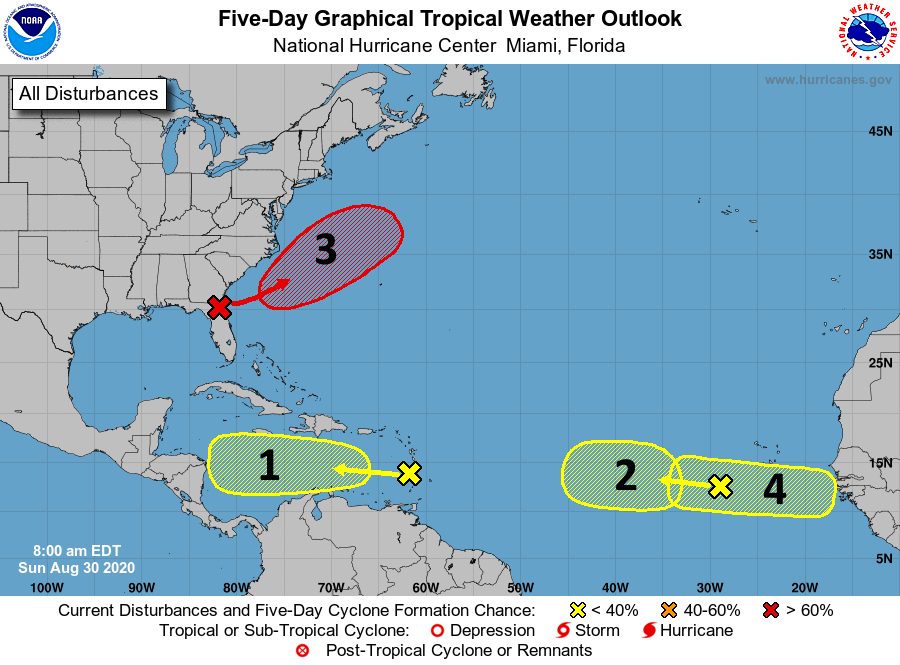
Let’s quickly run through them.
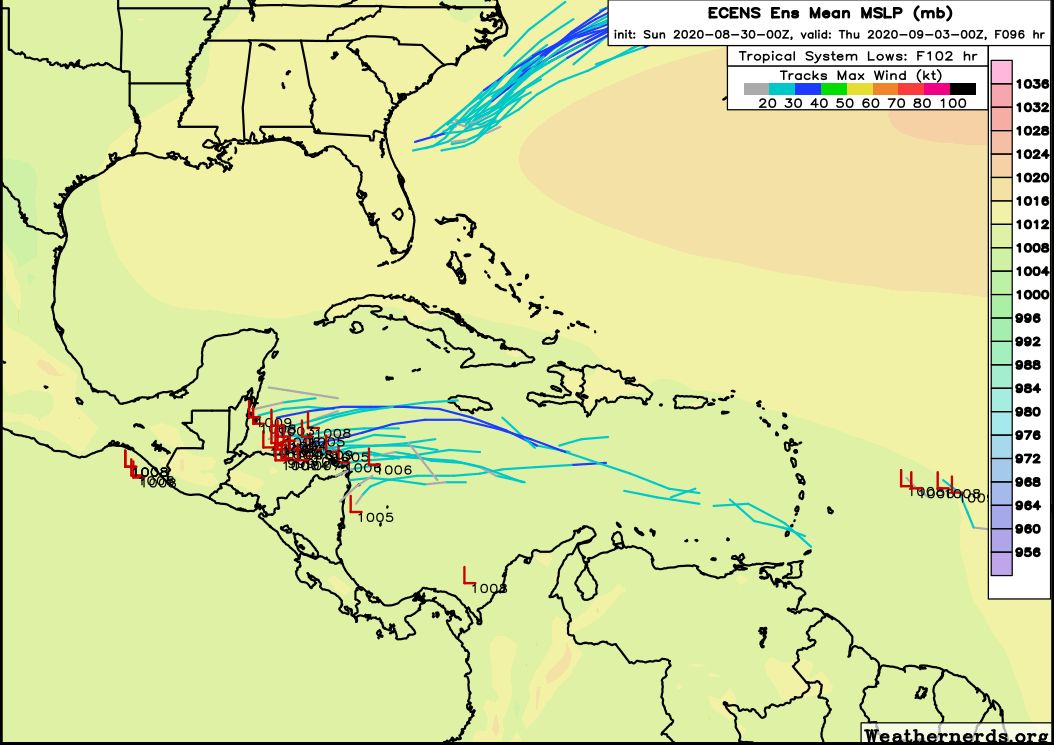
System One: On the face of it, this tropical wave moving through the Caribbean Sea would appear to be the biggest threat as it is closest, and we often see these systems turn pole-ward as they approach Central America. However for this tropical system we’re not convinced it will develop at all, and even if it does it most likely will continue plowing westward into Belize or Honduras. Here is the European ensemble forecast for the track of this system:
System Two: It is difficult to say whether this wave will develop, although its certainly possible. None of the forecast models are overly excited about this one, however.
System Three: This low-pressure system originated in the northwest Gulf of Mexico late last week, and is now crossing Florida. It probably will become a named storm (Nana is the next name) in the Atlantic, moving away from the United States. It will not threaten any major landmasses.
System Four: The forecast models are more bullish on this becoming a pretty well defined tropical system in about a week or so over the open Atlantic. It’s difficult to say where it would go after that, but most of the available evidence suggests it probably will not move toward the Gulf of Mexico. But as always, confidence in forecasts drops off after about 7 days.
Other threats: The peak of the Atlantic hurricane season comes in about 10 days from now, and we are seeing indications that several more potent tropical waves will move off of Africa into the Atlantic Ocean over the next couple of weeks. All of these will have to be watched. There is also the potential for something to develop in the Bay of Campeche (southern Gulf of Mexico) around 8 to 10 days from now that is worth watching. However any mischief there moving north is far from guaranteed—in fact a greater likelihood at this time is that our first fall front may be moving toward the region at that time. Cross your fingers!
So please: Be watchful of the tropics, and be wary. But at this time you should not be overly worried.

How much of an affect do fall fronts have on tropical systems in terms of steering or intensity?
Usually by the time the second cold front passes through southern Texas, the steering patterns are well established to drive any tropical mischief eastward and northeastward away from us.
Thanks Eric, we’ve been hoping that you’d weigh in on the latest blobs after resting up after Laura. Once again, just the facts. We appreciate all y’all do for us.
Thanks Eric the update!
Good Sunday Morning! Thanks so much Eric – I have been a fan of yours since your days at the Chronicle. I appreciate the work you and Matt do for us – you are the voices of reason, offering real help and information instead of hysterics. I have noticed the waves coming off Africa and I couldn’t really find anything giving a reasoned outlook for their futures. I was so happy to see this Sunday post – I know things change as they progress but you have given me a reason to breathe a little easier. Here’s hoping things turn out well for Houston in the next few weeks – and I am excited to see the words “cold front” starting to appear!!
Thank You for all the work you do to keep us updated.
thank you as always, great job!!
Again Eric…Bravo to you, Matt and Lee…thank you! I think it was the day, or day after Laura made landfall that another one of those pesky yellow “X’s” jumped off the African coast…really hacked me off…appreciate you covering them this morning.
My daughter told me about your website probably 2 1/2 weeks ago. It is refreshing to get no hype but the facts and the way you explain everything is amazing! I love seeing your maps the different forecast models that you use and then you explain it in terms that anyone can understand thank you so much for the information and keeping us informed during Laura. I have subscribed to your updates and look forward to reading them every day
I deeply appreciate your comments – especially after the exhausting week you guys have had.
Great presentation of the current situation. You guys have it down to an art. Presenting the facts, keeping readers as calm as possible, while at the same time having them be as concerned as they need to be. This is a tall order. You are certainly my first go to for weather, as I tend to be a beet anxious person.
Totally agree. Well informed but not worried!
I am a fan. Thank you , thank you!
Something tells me that the Fall Fundraiser this November is going to be VERY successful! Deservedly so.
When Blobs 1 & 2 first appeared on the NWS map just after Laura passed through, it was obviously concerning. I decided to try something with the Dark Sky weather app, and it was pretty interesting.
I went to the radar display, which you can zoom out for a global view, and then went to the blobs in the Atlantic. If you tap the animation button, it will show you what appears to be a visualization of current model runs on those blobs. At the time it showed one of them moving straight west and dissipating over the Yucatan, the second just kind of fell apart – which is what Eric is describing in his post. I don’t know how accurate the visualization is (as Eric said, forecasts more than a week out don’t count for much), but it certainly made me feel better!
Dark Sky is available now only for iOS; Apple bought it and shut down the Android version, unfortunately.
Excited to hear about the front that might have been a mirage. Will it mark down the odds of a hurricane coming our way? I seem to remember you saying something about the cold fronts marking some relaxing times for us topically speaking.
Eric and Matt, Thank you very, very much for your non hyperbolic analyses of our weather conditions. I have friends of mine around the country checking your website when things start to get exciting down here, including one in Lafayette, La..
My question is, what happened to the storm surge that was predicted to be possibly as high as 20 feet according to The Weather Channel on TV?
Barry O’Dwyer
Houston
Good work last week guys. I hope you got some much-deserved rest.
Just so ya’ll know, Eric and Matt, this old grandma has decided to adopt ya’ll… from now on, you are MY guys!!!
Thank you so much! We have horses and try to stay very in tuned in case we need to move them. I was concerned we were in for a repeat of Laura right on the heels. Feeling very weary. I can breathe now. Really appreciate everything you all do!
Excited beyond words that a cool front may arrive middle of next week. Even better is fact that hurricane threat seems to disappear after fronts start arriving. Then I remembered. It’s 2020. NVM.
Thank you so much for all you guys do. Found you before Harvey and you guys have me coming back daily since. Loved the tech article by lee. I just renewed with reliant at the start of the summer in big part because of their sponsorship. Keep it up 👍
Ok Eric, now that things are a bit calmer on the hurricane front, I’ve got a non-weather question I’ve wanted to ask for a very long time.
Prior to your stint at the Chron, did you spend some time working for a certain newspaper in South Montgomery County after arriving in the Houston area?
Have to tell you, I always enjoyed your pieces on NASA and space travel as well as your weather work.
Thanks