In brief: Houston is beginning the first of four days of warm and windy weather, with Saturday looking especially gusty. Rain chances start to increase on Sunday afternoon, with much of the region in line for a decent soaking to start next week. This post also briefly touches on the looming onset of an active hurricane season, which begins in a little more than a month.
A few notes on the tropics
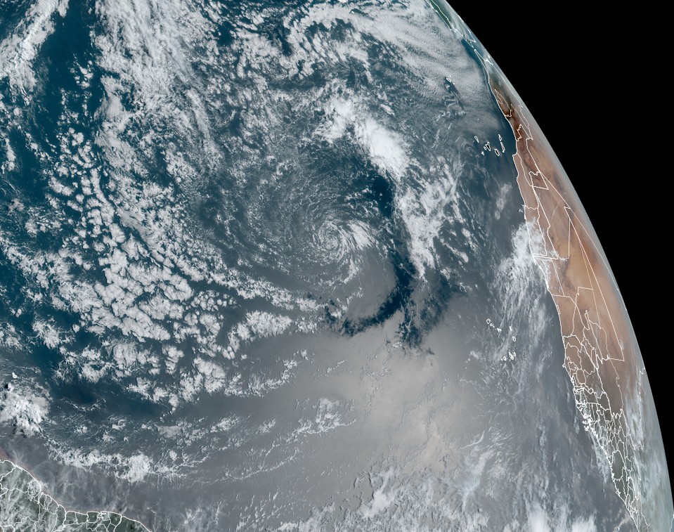
The National Hurricane Center issued its first “special tropical weather outlook” of the year on Wednesday, concerning a low pressure system far out in the Atlantic Ocean. This system has virtually no chance of becoming even a subtropical depression, but it is a sign of things to come. We are just a little more than five weeks away from the official beginning of the Atlantic hurricane season, but it would not surprise me to see a May storm this year given the warmth in the Atlantic tropics.
Another fairly influential group, at the University of Pennsylvania, issued its tropical forecast this week. The researchers predict a blockbuster season, with a best estimate of 33 named storms. This seems preposterously high, but typically the Pennsylvania forecast predictions are reasonably accurate, and typically conservative relative to overall activity. It’s another reason for concern. Speaking of the busy forthcoming season, Matt and I want to thank Houston City Councilwoman Abbie Kamin for the shoutout at City Council on Wednesday. Finally, this is a tax-free weekend for purchasing hurricane supplies in Texas. Details here.
Thursday
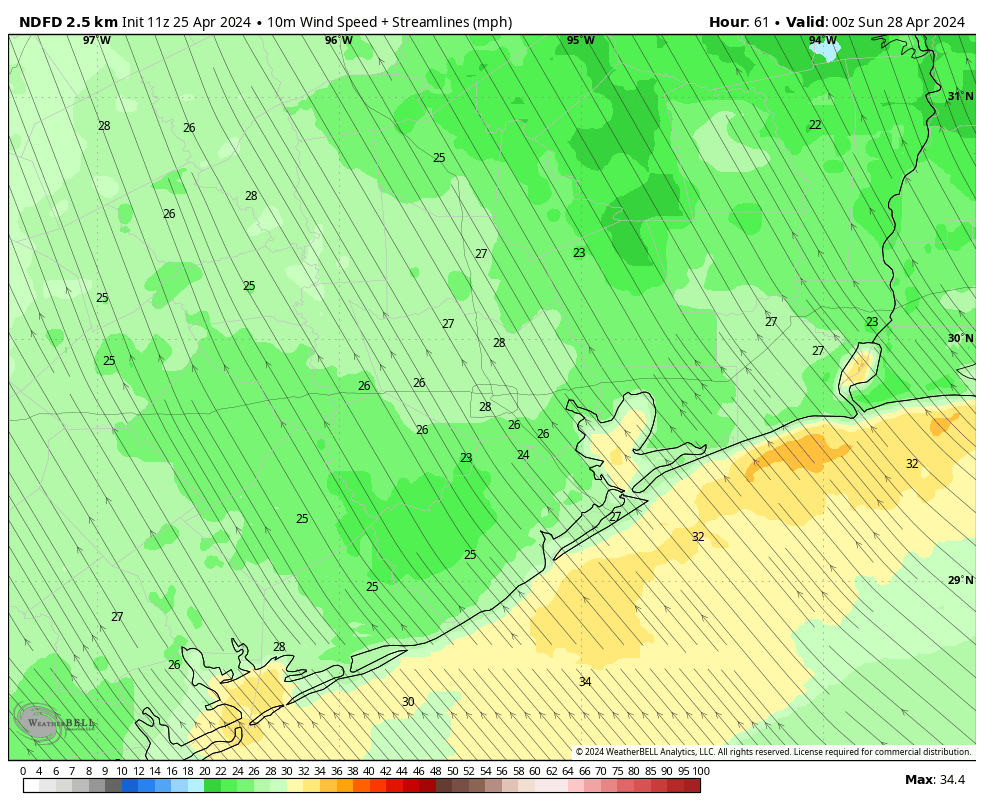
We’ll begin to see stronger southerly winds today as pressure gradients tighten in response to lower pressures over the central United States. This will help to create a persistent southerly flow over the region through the weekend, and peaking on Saturday. Today, winds will blow from the southeast at 10 to 20 mph, with gusts up to 30 mph. Skies should be mostly cloudy, with highs reaching the low 80s for most locations. Winds will continue overnight, with lows only dropping into the low 70s.
Friday
Another mostly cloudy and windy day. Highs might be a degree or two warmer than Thursday, with wind gusts possibly reaching 35 mph. Some showers and thunderstorms will be possible on Friday afternoon and early evening, but I think these will be fairly scattered due to a capping inversion. For now I’d peg rain chances at perhaps 10 to 30 percent. Friday night will be warm again.
Saturday
The first half of the weekend should see the strongest winds of the week, with south-southeasterly gusts up to 40 mph possible from the south. We should also see at least partly sunny skies, allowing highs to reach the mid-80s, and possibly the upper-80s for some locations. We covered the Texas Bike MS 150 in depth in yesterday’s post, and the forecast remains similar. If you’re participating in that, or the Ironman event in The Woodlands, be prepared for warm, humid weather and very strong winds from mid-morning through Saturday evening.
Sunday
Another warm and windy day, although gusts should be a bit lower, perhaps only reaching 30 mph from the south-southeast. Look for highs generally in the mid-80s with partly sunny skies giving way later to clouds. Beginning Sunday afternoon in the Houston area, in response to an upper-level system, expect to see rain chances increase across the area. Chances on Sunday will be greatest to the northwest of Houston, bust most of the region will probably see a smattering of rain on Sunday afternoon, evening, or overnight.
Next week
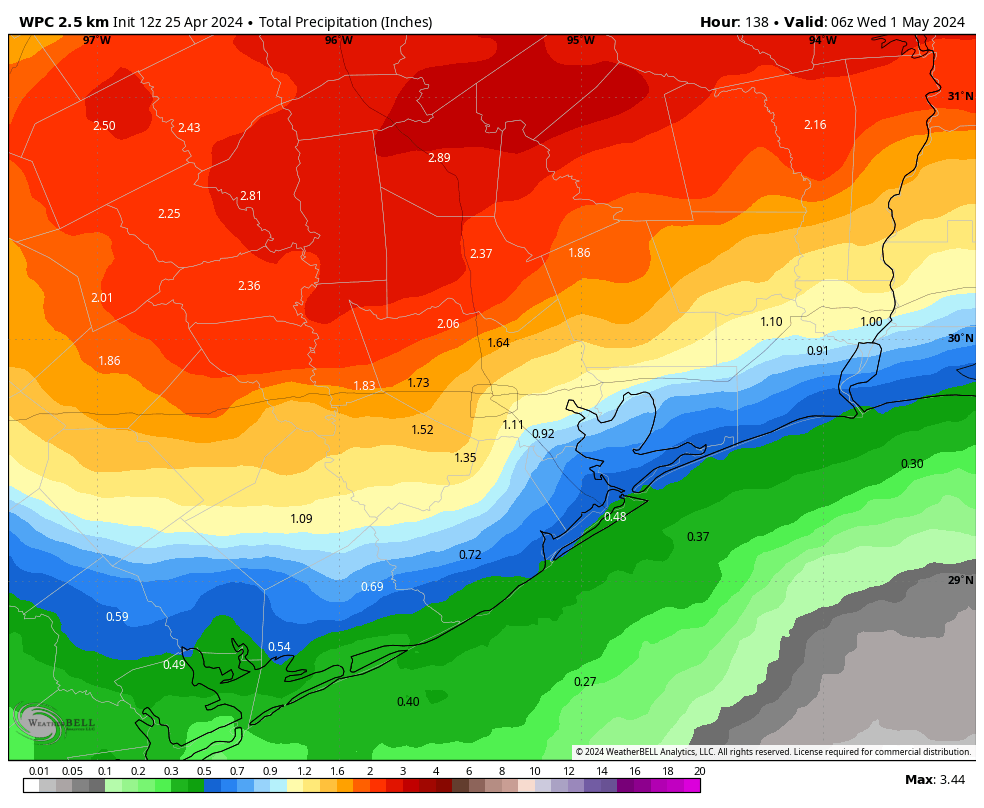
Monday and Tuesday will see a healthy chance of rain showers, although the details remain uncertain about amounts. I’m hopeful that much of Houston will pick up 0.5 to 1.5 inches, which would be welcome given our drying soils this week. For the most part we can expect highs in the mid-80s to upper-80s later next week, with lows around 70 degrees. Humidity looks high all week. There could be a fair amount of sunshine. We’ll see.

While I’m not wild about warm and windy, I’ll look on the bright side and hope the windy conditions will drain the mosquitoes’ life force as they struggle to fly.
Yup, I’m really trying hard to find a silver lining. Ha ha!
I am skeptical of anyones ability to accurately forecast the weather outside of say 10 days. But with El Niño fading and La Niña building it does seem like a perfect storm brewing in the Atlantic this season. Low wind shear, warmer sea surface temps and an active West African monsoon seem to be the perfect petri dish for tropical trouble later this summer. I am still suffering PTSD from Harvey…
That makes two of us. Personally, I am trying to relocate while I still can. I do not have another hurricane season left in me. I feel you, Sir.
Same on all accounts, especially Harvey.
Are the windy conditions all day or during certain time periods? Looking specifically at Friday.
There’s a low passing across the mid con to the north of Texas pulling in the air. So as the blog says expect strong southerlies. Weakens Friday night. Another passes by Saturday albeit closer so more energy here. Stronger southerly.
33 named storms. What does that mean other than hype? Hurricanes have always been in this area, just look to the history books. Plenty of devastating hurricanes back then. Populations were nowhere close to where we are today and no industrial pollution to talk about (colonial period).
I’m truly excited about the seven or so months I get to panic almost all the time in regards to the weather. 🙁
The winds for the first day of the MS150 are problematic for inexperienced cyclists, who may not have the road knowledge of more confident cyclists who generally know how to ‘ride’ out the winds. Be careful, a strong gust even in the right direction can cause havoc amongst cyclists riding too close in a crowd.
misty rain here in Bellville
Geoengineering affecting our hurricane season this year, along with other manmade global
changes. Unlikely most of this can we unwound….the arrogance of humanity; pride cometh before a fall,
and it will be a big one.
You just might be the most refreshing human being in the entire Comment Section. Thank you for your words. Nothing could be closer to the truth.
The industrial revolution started up in Britain at the latter half of the 18th century and changed the landscape entirely before spreading to much of the rest of the then developing world. The consequent disaster that improved our lives at the cost of our futures took over 200 years and will not be undone in our life times.
Do you have advice on preparing for Hurricane season? Specifically is there anything that I can purchase in advance of, to protect against flooding in a southeast neighborhood?