Changes are coming to the Houston region beginning late tonight and tomorrow morning, taking us back into a wintry pattern for a couple days. Let’s break it all down.
Today
It actually should not be a terrible day today overall. It will continue quite warm and humid, but rain chances look low for most. The best chance of showers today would be for areas east and north of Houston, with a slightly better chance late today versus earlier. So have the umbrella, but I would be fairly surprised if you actually needed to break it open.
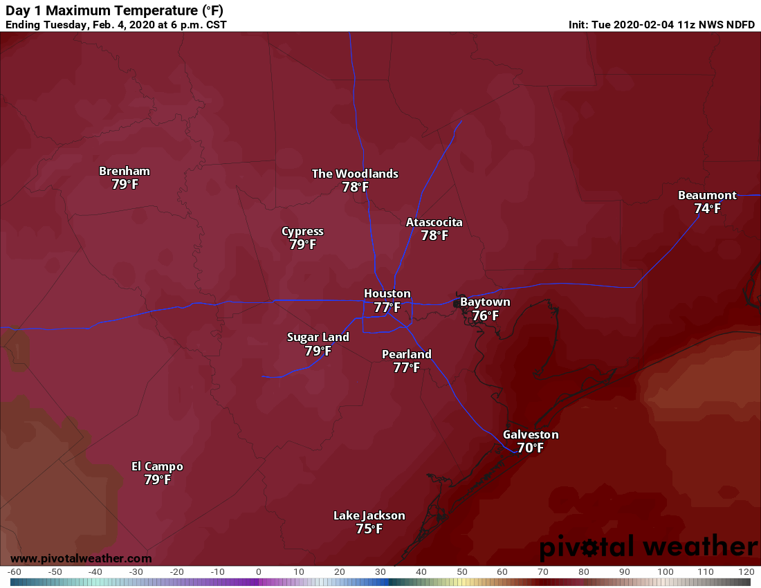
Today will be quite warm. We should be able to reach the upper 70s with little trouble today, and I think several 80 degree readings will be reported, particularly if we can break the clouds a bit. Some patchy fog is possible in Galveston or near the bays as the day goes on. It will probably be breezy again today, but winds should not be quite as strong as Monday.
Tonight & Wednesday
The chance of showers and even a few heavier thunderstorms will pick up overnight tonight and into Wednesday morning as our cold front approaches. We are not expecting any severe weather at this time.
In terms of timing, I think the front will approach the northwest suburbs between 10 PM and 1 AM tonight. From there, it gets a little trickier to exactly time out, but in general, a southeastward push of colder air should work across the region from the north through the morning.
Temperatures early tomorrow will be all over the place. Behind the front, essentially from Houston north and west, tomorrow morning should already be in the upper 40s through mid 50s. South and east of Houston may be in the low to mid 60s. The front will probably stall over Houston in the early morning, then resume a slow south and east slog by to mid late morning, reaching the coast by Noon. If you’re still on the warm side of the front tomorrow, look for a slow, steady 10-15 degree drop in temperatures after it passes. We should all drop back into the 40s (low 40s N & W, upper 40s near the coast) Wednesday afternoon. These shallow, cold air masses tend to overperform more often than they underperform around here, so I’m taking a slightly more aggressive posture with things today
In addition, it will be breezy behind the front, adding an extra chill.
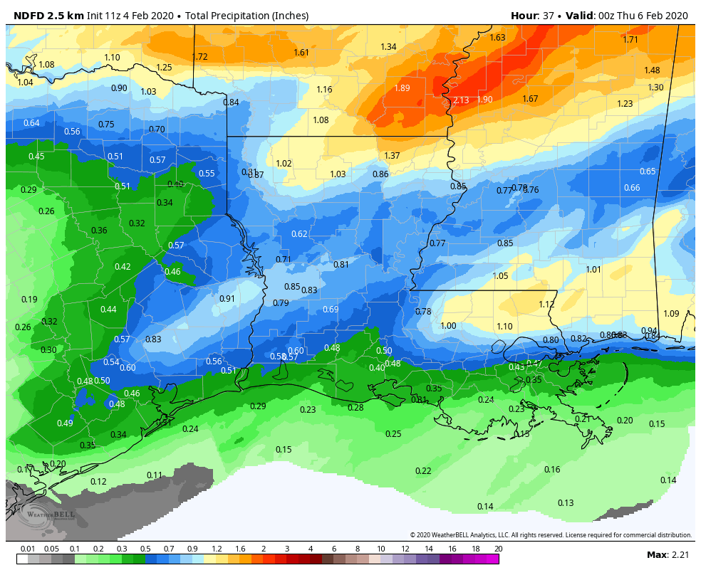
Rain totals will range from a half-inch or less south of Houston to perhaps near an inch in a few spots north. Showers should taper off in the afternoon on Wednesday.

Wednesday night & Thursday
Trying to forecast winter weather in the Southern Plains is always tricky. Just to be clear out of the gate, whatever occurs tomorrow night probably won’t amount to much of anything impactful, but it might make for some fun water cooler conversation on Thursday. Temperatures Wednesday night should bottom out in the 30s, with some near-freezing temps possible north and west of Houston (not a hard freeze or anything).
The overall theme is that a final disturbance will swing through the area, with a narrow area of precipitation, coinciding with those temperatures possibly cold enough to produce snow or ice pellets (sleet) in addition to plain rain. The most likely areas to see a mix of rain and snow or rain and sleet would be northwest of Houston. Draw a line from Katy through The Woodlands to Lake Livingston, north and west of there. Judging by atmospheric profiles, I think sleet is more likely than snow to mix in with rain at this point, but these mixing events can be volatile with precip going from rain to snow to sleet and back again. Once more, I don’t think this will have any tangible impacts, but it is some wintry excitement in an otherwise unexciting winter.
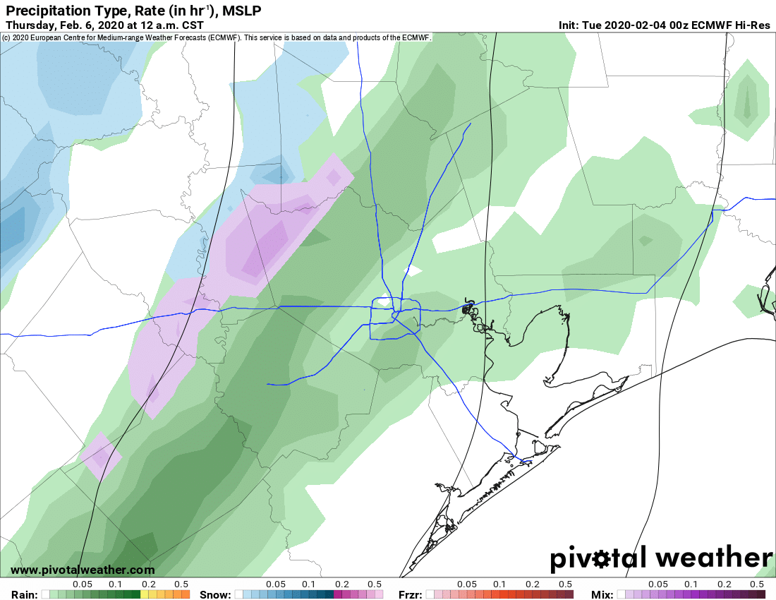
The timing on this looks to be between midnight and 6 AM tomorrow night. It’s going to be a very brief window. That aspect of the forecast has the highest confidence. Precip should be light, but there are some hints that a couple pockets may briefly see some moderate rain or mixed precipitation. Again, given the short-duration (~6 hours) and the fact that we’ve been flirting with 80 degrees lately, we don’t think this can accumulate in the Greater Houston area if it occurs here. Perhaps a few folks well north, near Huntsville or back toward the Brazos Valley could see a minor coating on grassy surfaces.
Thursday should see clouds and any lingering precipitation in the morning end, giving way to sunshine as the day goes on. Look for low to maybe mid 50s on Thursday afternoon.
Rest of the week/weekend
Friday looks stunning, with full sunshine and highs in the 60s after a morning in the 30s or low 40s. A weak front on Saturday may come close and bring some clouds or a shower, but overall it looks fine for now and we’ll flirt with 70 degrees. Sunday should see onshore flow resume with a mix of clouds and sun. This likely sets up a warm, humid week next week though details are TBD at this point.
Southern Plains snowstorm
Just a quick note. If your travel plans take you to Wichita Falls, Lubbock, Midland, or Oklahoma City tonight or tomorrow, be prepared for inconvenience.
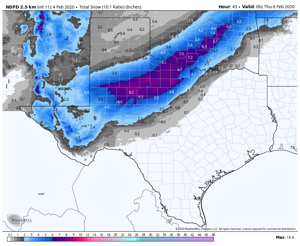
A pretty healthy snowstorm is expected in those areas. These events are always subject to last second changes, but anywhere from 3 to 6 inches of snow is possible over a large swath of that area, with higher amounts of 6 to 8 inches likely. This will lead to significant travel disruptions in those areas. The worst will be later tonight into the first half of Wednesday.